Carran Manning, thank you so much for your reply and advice. Laymen have so many questions about this industry and need help at times.
JJ
Carran Manning, thank you so much for your reply and advice. Laymen have so many questions about this industry and need help at times.
JJ
Good morning Susan,
I tried pulling up this info last night but the RR Commission GIS Mapping System was down for maintenance.
Henderson County A-437/J. Lewis Survey. I don’t see any activity in the area at this time but a well was permitted in the past few months east of your minerals about 2 miles. Also to the south of Brownsboro about 8 to 10 miles some fairly good oil/gas wells are being drilled by OBenco, Inc., Eagle Land Service and others. These wells are in the neighborhood of the Henderson/Anderson County line. This link is to the completion report on well API # 213-31048:
GIS Map of Henderson County Texas J. Lewis Survey/A-437 and surrounding area:
Thanks so much for the information Clint. Very helpful.
Susan,
This link is to the well that is being drilled 2.66 miles east of your minerals. Spud (began drilling) date was September 14, 2014: API # 213-31055
Clint Liles
The Eagle Land Ned #1 well has reached TD and rig has moved off location. Rumor is that it has been plugged but cannot confirm.
Well was a rank wildcat test.
Thanks for the update Rockman.
Lots of rumors surrounding the Eagle Land Ned well and associated leasing activity from there back to the east along the highway toward county line.
Rumors of several operators leasing for new target horizon.
I would like to know a ballpark figure of what is being offered for a 3 year lease on acreage in Henderson and Van Zandt counties. It has been over 20 years since these minerals were last leased.
Thanks,
Mark
Mark,
It would depend on the location in Henderson County. In the past year or so not much at all happening in Van Zandt County. Southern Henderson County and around Cedar Creek Lake area some exploration is taking place. If you have the Abstract # of the Henderson County minerals I can look it up on the GIS Map and see what activity if any is in your minerals area.
Clint Liles
Clint How about abstract 581? Thank you
Wes,
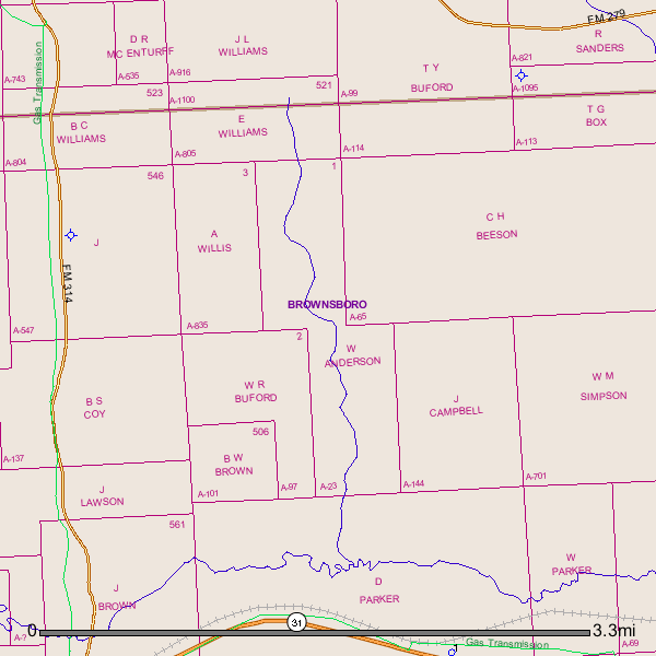
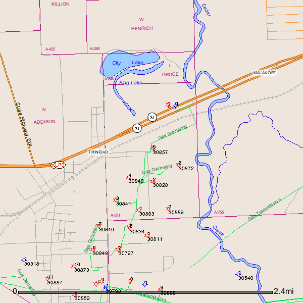
The RR Commission Public GIS Viewer is down for maintenance so I used the GLO (Government Land Office) mapping system. Your minerals are located just east of the city of Trinidad, Texas.
GLO Map of Henderson County, Texas A-581 and surrounding area:
Clint Liles
Clint,
The minerals are located in Ab# 23, 65, 114, and 805. This is the Ab.# for Henderson. Part of the surveys lie in Van Zandt with different Ab.#.
Thanks,
Mark
Thanks Clint,
As to my original question any idea on what is being offered in this area for a 3 year lease?
Mark
Mark,
If I were you I wouldn’t sign a lease at this time. Need to find out how the Ned well turns out and if it is a good well your bonus and royalty monies will increase by a substantial amount. This well API # 213-31055 is an Exploratory Test Well. The Goodland Lime is one of the formations that is being targeted in Henderson, Anderson and parts of Smith County. Also the Paluxy and Rodessa formations will possibly be checked. For sure what the going rate is for bonus money per acre I have no idea. Possibly some of the other Henderson County Group members will chime in.
Clint Liles
Eagle Land is supposedly a cover company for Chesapeake. They have put together a decent acreage position surrounding this well (Ned #1). Well has been drilled and “plugged” - figure core and data is being evaluated at this time. Gyro was run in the well so good chance CHK will come back with different rig and drill a horizontal to test the Goodland.
Word is that leases in the area were getting $250 to $500 per net acre for 3 year primary terms with 2-3 year kickers on the back end.
This (Goodland) is the same play that EOG is making in Smith County around Noonday / Saline Bay south of Tyler.
Rock Man and Clint,
Thanks for the information. At least now I have an idea of what is going on up there. This is a very helpful group and am glad I stumbled upon it.
Mark
Thanks Rockman for your input. Personally I hate to see Chesapeake in the area. I was hoping they would just vanish.
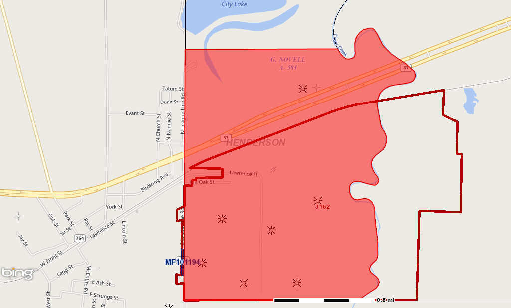
Mark this is the RRC Public GIS Map of your minerals:
Clint Liles
Clint Thank you. Is there drilling activity in this area?
With respect to A-581, Silver Tusk is drilling what appears to be Travis Peak wells about 4-5 miles due east of this abstract. On the flank of Tri Cities Field.
Stroud - who operates the Trinidad Field area that runs south of Highway 31 as shown on Clint’s map, has their entire producing area up for sale at November Clearinghouse auction. Only making about 500 MCF per day from entire field right now.