Henderson County, Texas oil & gas discussion group. Share your experience regarding lease bonus, royalty rates, drilling activity, and oil & gas news.
Does anyone have any information concerning bonus money being paid in Henderson County for leases? Also, does anyone have any experience or information on a Leasing Agent in Tyler named Eiche, Mapes and Company? They have contacted me claiming to be representing an exploration company that has little Texas experience.
Ken,
Eiches, Mapes and Company are a well known, trusted and long established landman company in Tyler. I’ve never heard any negative things about the company. Good luck on your lease.
Ken,
Clint is correct - Eiche Mapes are a long-established landman brokerage in Tyler. They represent a number of oil and gas companies in a number of different areas. What Survey / Surveys are your minerals in and what is their offer? Regards.
Good Morning Ken I was wondering if you ever made an offer on your minerals in Henderson County Texas? If so if you don’t mind my asking how much they offered you?
My Mom has mineral rights around Chandler, Texas. I have been contacted by a landman, but have received no specific offer to lease. Can anyone tell me who the major leasing companies are in the area and what estimated range of lease money per acre and amount of royalty is currently being offered. Also, should I considered going through an attorney to negociate a lease, and if so, any referrals? THANKS!
Rich
What is a reasonable price per acre for buying mineral rights in Henderson County?
I have been offered $60 an acre.
thanks,
RW
Is there any drilling activity or leasing info. ? New member. Thanks
johnny,
Not much going on for Henderson County Texas. Since January 2012 there have been 17 approved permits issued by the RR Commission. 9 of those were for new drill and 8 were for recompletions. Am posting a link for 2 pages of permits back to Jan. 2012. Click on the Lease Name to view each permit.
Thank you.
JJ
I'm not sure where to post this but I thought I would start here.
I inherited mineral rights in Henderson County on 400 acres. I am looking to sell the mineral rights. Does anyone have contacts for companies that are currently interested in purchasing mineral rights in the area? Any assistance would be greatly appreciated. Decker Energy leased the rights in 2009 for 3 years and did not renew. I was told they drilled, fracked and capped. Unemployment has forced the need to sell these rights ASAP. The rights are recorded in the Thomas Parmer Survey A-782. Inherited from the Boone family.
Beware there is a petroleum company in the area attempting to pay only hundreds of dollars for mineral rights in Henderson County for areas in which we have been offered approximately 10 times as much. Just sayin’ = tax basis is on land not mineral rights - be cautious. “We didn’t want to insult your intelligence, we’re just basing the offer on land value…,” yeah right - fk off.
Looking for information on activity in the A. Amglin South Survey.
Donna,
What is the Abstract, Section, and Block numbers?
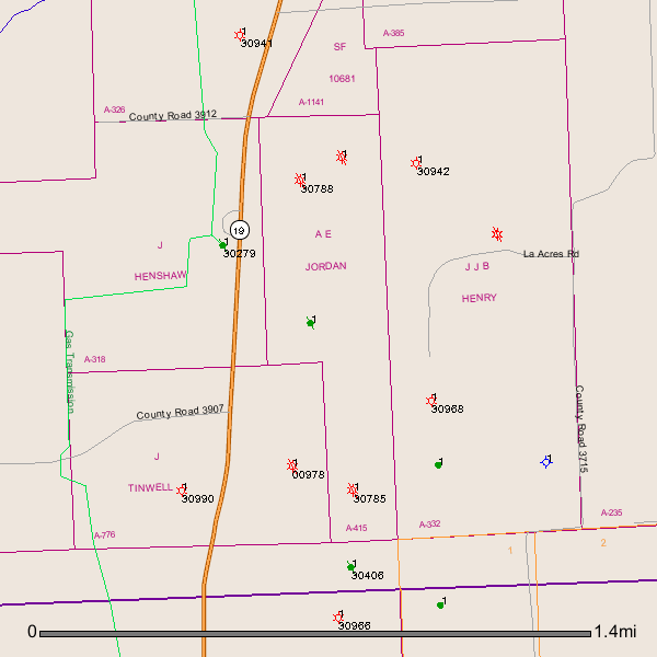
Clint, that is the only description that I have. It is listed that way in the Exhibit B section of a document giving my mother a 1/3 interest in all my step-grandmother’s minerals when she died. Other Henderson County property I am interested in finding out about is BC Walters Survey, A-797; J Tidwell Survey, A-776; and the AE Jordan Survey, A-415 and described as the east 80 acres of 143.76 acre tract. However, the Amglin South Survey is listed as just that…
Donna,
As a whole not much activity going on in Henderson County, Texas.
Henderson County A-797/B C Walters Survey Located in the northern part of Athens, Texas.
I see 3 dry holes have been drilled in A-797 (30467, 30783, 30913)
GIS Map of A-797:
Donna,
Adjacent to and north of your A-797 is A-776. I see 1 gas well (30990) and 1 plugged gas well (00978).
GIS Map of A-776:
Donna,
A-415 has 2 plugged gas wells (30785, 30788). Green dot with a stick through it is a plugged oil well.
GIS Map of A-415:
Clint Liles
Clint - this is awesome - exactly what I have been looking for for several weeks - just didn’t know how to get my hands on a survey map! Thank you!
Donna,
We have 3 holdings in Henderson County, I’ll look up the property information and let you know which Surveys our property relates to - Good luck with your research.