Hi J, I could not get the paper to open. If you could give me some details such as title, author, subject, and date, maybe I can find it from another source and post a link. Thanks
j richard said:
http://search.yahoo.com/search;_ylt=A0SO8x.y8a1SQV4AZnhXNyoA;_ylc=X... USGS Report (hope this link works!) on pg. 22 & 38 a large amount of oil is shown around the Canyon sand/shale. A lot was bunched up around Howard-Glasscock field; but Howard-Glasscock is San Andres not Canyon. According to Laredo Cline is Pennsylvanian and Apache calls shale between Wolfcamp and Cline, Deadwood Shale. If this link works this paper is worthy of discussion; if not perhaps our moderator can get the paper to post.
Craig Wascom said:
I would have thought the line would be a lot farther west, I am not surprised of that result that far east.
Ralph T said:
On the "Good, Bad and Ugly" board there is a RRC report from Devon Horizontal IP 4.5 miles west of Maryneal in southwestern Nolan County, showing 22 BBL on a 1000' foot horizontal from April 2013. That appears to be about the location of red line of the Eastern Shelf in Nolan County. That suggests to me that there isn't much going to happen in the current round of activity.
Whoa Nellybelle I can't get it to open either (and will reserve my tin foil hat comments) and have read it four times. It has some good stuff.
Author: Keith Robinson
Open File Report 88-450Z
Publication United States Geological Service 1988 (with source from 1979-1981)
Craig Wascom said:
Hi J, I could not get the paper to open. If you could give me some details such as title, author, subject, and date, maybe I can find it from another source and post a link. Thanks
j richard said:
http://search.yahoo.com/search;_ylt=A0SO8x.y8a1SQV4AZnhXNyoA;_ylc=X... USGS Report (hope this link works!) on pg. 22 & 38 a large amount of oil is shown around the Canyon sand/shale. A lot was bunched up around Howard-Glasscock field; but Howard-Glasscock is San Andres not Canyon. According to Laredo Cline is Pennsylvanian and Apache calls shale between Wolfcamp and Cline, Deadwood Shale. If this link works this paper is worthy of discussion; if not perhaps our moderator can get the paper to post.
Craig Wascom said:
I would have thought the line would be a lot farther west, I am not surprised of that result that far east.
Ralph T said:
On the "Good, Bad and Ugly" board there is a RRC report from Devon Horizontal IP 4.5 miles west of Maryneal in southwestern Nolan County, showing 22 BBL on a 1000' foot horizontal from April 2013. That appears to be about the location of red line of the Eastern Shelf in Nolan County. That suggests to me that there isn't much going to happen in the current round of activity.
Good USGS report but remember it is from 1988. Authors at this time had no inkling of the potential that existed in the Cline, Wolfcamp, Spraberry and other other formations due to horizontal drilling and frac technology. So one needs to put this in perspective to what had been happening in the basin 25 years ago.
j richard said:
http://search.yahoo.com/search;_ylt=A0SO8x.y8a1SQV4AZnhXNyoA;_ylc=X... USGS Report (hope this link works!) on pg. 22 & 38 a large amount of oil is shown around the Canyon sand/shale. A lot was bunched up around Howard-Glasscock field; but Howard-Glasscock is San Andres not Canyon. According to Laredo Cline is Pennsylvanian and Apache calls shale between Wolfcamp and Cline, Deadwood Shale. If this link works this paper is worthy of discussion; if not perhaps our moderator can get the paper to post.
Craig Wascom said:
I would have thought the line would be a lot farther west, I am not surprised of that result that far east.
Ralph T said:
On the "Good, Bad and Ugly" board there is a RRC report from Devon Horizontal IP 4.5 miles west of Maryneal in southwestern Nolan County, showing 22 BBL on a 1000' foot horizontal from April 2013. That appears to be about the location of red line of the Eastern Shelf in Nolan County. That suggests to me that there isn't much going to happen in the current round of activity.
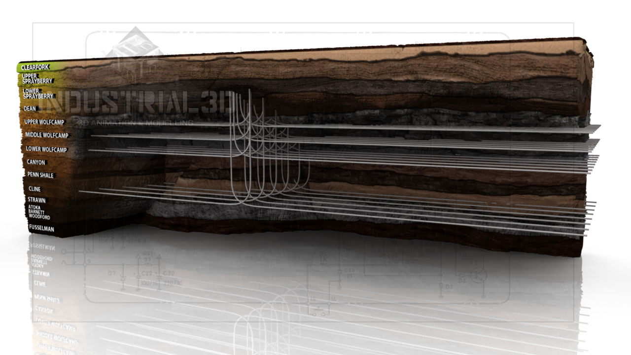
dustrial 3D Inc. What I was trying to express with 1988 USGS Paper. The Wolfcamp is separated from the Cline by shale. The Wolfcamp D and the Cline are not the same.
Wolfcamp to Cline transition will vary across the Midland Basin / Eastern shelf - it is not a consistent "layer cake" series of horizons.
Aside from having hundreds of logs and looking at the transition on a well by well basis across the basin / area, the only really good way to differentiate one from the other is to use paleontology (bugs) to ID Wolfcamp (Permian) vs. Cline (Pennsylvanian).
In some areas, the Wolfcamp and Cline are pretty much the same depositional environment while in others there are some significant differences. Horizons / strata between the two varies depending on the area. In some cases there are obvious carbonate and/or clastic intervals separating the two. In other areas they basically sit on top of one another with only a minimal (or no) separating lithology.
Complicated for sure. Not a simple situation especially when looking across thousands of square miles of area.
dustrial 3D Inc. What I was trying to express with 1988 USGS Paper. The Wolfcamp is separated from the Cline by shale. The Wolfcamp D and the Cline are not the same.
Slides like this underscore the fact that each company views the subsurface differently in many instances. It is like looking at a translation of the subsurface in Hebrew vs. Greek - same original language but different interpretations depending the language being translated to.
The only true way to differentiate one from the other is to have all the data across a wide area and then make your own interpretation.
This stratigraphic relationship is not a clear cut difference like Woodford vs. Devonian or San Andres vs. Grayburg. In fact, IMO it is the perfect definition of "grey" vs. black and white differences.
Which brings me back to a comment that has been laid out previously - getting in heated discussions as to Cline vs. Wolfcamp D is not worth the concern and effort. Almost like politics and religion in many respects.
Thank you Przzz your comments are always welcome. I don't mean to be heated discussion am just saying it makes a difference to Nolan and Mitchell Counties for example. One of these days I am going to see if you will explain to me how Midland Basin and Val Verde transition. Thank you very much for all your posts I always learn from them.
Przzz said:
Slides like this underscore the fact that each company views the subsurface differently in many instances. It is like looking at a translation of the subsurface in Hebrew vs. Greek - same original language but different interpretations depending the language being translated to.
The only true way to differentiate one from the other is to have all the data across a wide area and then make your own interpretation.
This stratigraphic relationship is not a clear cut difference like Woodford vs. Devonian or San Andres vs. Grayburg. In fact, IMO it is the perfect definition of "grey" vs. black and white differences.
Which brings me back to a comment that has been laid out previously - getting in heated discussions as to Cline vs. Wolfcamp D is not worth the concern and effort. Almost like politics and religion in many respects.
Think of the Midland to Val Verde transition as going from one basin (MIdland), crossing a high ridge that separates the two and then dive into the Val Verde Basin area.
Different types of deposition and organics at various times (i.e. Penn vs Permian) plus different thermal story vs. the Midland basin.
If I get some time I will see if I can dig up some deep logs from Nolan and MItchell and see if I can put any "hard" picks on the Wolfcamp to Cline issue from my perspective
j richard said:
Thank you Przzz your comments are always welcome. I don't mean to be heated discussion am just saying it makes a difference to Nolan and Mitchell Counties for example. One of these days I am going to see if you will explain to me how Midland Basin and Val Verde transition. Thank you very much for all your posts I always learn from them.
Przzz said:
Slides like this underscore the fact that each company views the subsurface differently in many instances. It is like looking at a translation of the subsurface in Hebrew vs. Greek - same original language but different interpretations depending the language being translated to.
The only true way to differentiate one from the other is to have all the data across a wide area and then make your own interpretation.
This stratigraphic relationship is not a clear cut difference like Woodford vs. Devonian or San Andres vs. Grayburg. In fact, IMO it is the perfect definition of "grey" vs. black and white differences.
Which brings me back to a comment that has been laid out previously - getting in heated discussions as to Cline vs. Wolfcamp D is not worth the concern and effort. Almost like politics and religion in many respects.
I find this discussion important not because I think we will come to a conclusion but in discussing, those of us who know very little, pick up some knowlege. Thanks for your comments.
Przzz said:
If I get some time I will see if I can dig up some deep logs from Nolan and MItchell and see if I can put any "hard" picks on the Wolfcamp to Cline issue from my perspective
j richard said:
Thank you Przzz your comments are always welcome. I don't mean to be heated discussion am just saying it makes a difference to Nolan and Mitchell Counties for example. One of these days I am going to see if you will explain to me how Midland Basin and Val Verde transition. Thank you very much for all your posts I always learn from them.
Przzz said:
Slides like this underscore the fact that each company views the subsurface differently in many instances. It is like looking at a translation of the subsurface in Hebrew vs. Greek - same original language but different interpretations depending the language being translated to.
The only true way to differentiate one from the other is to have all the data across a wide area and then make your own interpretation.
This stratigraphic relationship is not a clear cut difference like Woodford vs. Devonian or San Andres vs. Grayburg. In fact, IMO it is the perfect definition of "grey" vs. black and white differences.
Which brings me back to a comment that has been laid out previously - getting in heated discussions as to Cline vs. Wolfcamp D is not worth the concern and effort. Almost like politics and religion in many respects.
This is Pioneer in Crockett near the Crockett-Reagan line. I have never seen a tank battery this large before. Sinochem will be very pleased with their joint venture.