What is the proper description of the Cline Shale. Is it the same as the Lower Wolfcamp or Wolfcamp D?
It is the same yet different. And the lithology / thickness / mineralogy / thermal history / organic content / etc. varies across the Midland Basin north to south and east to west.
In the guts (deep) of the paleo Midland Basin (i.e. when these formations were deposited), one is looking a deep, quiet water area and low tidal / wave energy. Basically an enclosed basin in warm/ semi arid area. Not a lot of rain and evaporation is a key weather factor.
Deposition is a mix of sediment that is settling out from the water in the basin plus sediments being shed into the basin from the adjoining higher platforms and shelf areas that rim the basin.
Very fine grained sediment is the rule - siltstones and fine grained carbonates being deposited in a rhythmic sequence of layers over time. Silt, limestone, shales,mixes of all three aforementioned members, some organic rich, some organic poor. Thickness of individual zones varies from a few inches to tens of feet. And the areal extent of any one "depositional body" can range from a few acres to covering miles of area.
Biggest difference between the two formations is the age of the section. The Cline in Pennsylvanian in age while the Wolfcamp is younger (Permian).
This is thumb nail overview of the system. Obviously a lot more complexity than what is shown here.

I really like this graphic and I think I am starting to get it. So I am going to ask what might be a really dumb question. Does the graphic represent the ancient sea basin and the yellow the deposits Przzz is talking about?
An excellent post for those that want to learn. Some consider this discussion not" news"- I beg to differ. In the Laredo September 2013 presentation turbidity seemed important to them on one of their slides. As for mineral rights. I want to know every thing I can about my minerals to the smallest detail. Wolfcamp or Cline? Is certainly relevant for vertical pugh clause, allowable and acreage designation from the Railroad Commission. Thank you for the post, I want to know more since this is an historical play. I mean Pioneer says it's number 2 behind Saudi Arabia.
Przzz said:
It is the same yet different. And the lithology / thickness / mineralogy / thermal history / organic content / etc. varies across the Midland Basin north to south and east to west.
In the guts (deep) of the paleo Midland Basin (i.e. when these formations were deposited), one is looking a deep, quiet water area and low tidal / wave energy. Basically an enclosed basin in warm/ semi arid area. Not a lot of rain and evaporation is a key weather factor.
Deposition is a mix of sediment that is settling out from the water in the basin plus sediments being shed into the basin from the adjoining higher platforms and shelf areas that rim the basin.
Very fine grained sediment is the rule - siltstones and fine grained carbonates being deposited in a rhythmic sequence of layers over time. Silt, limestone, shales,mixes of all three aforementioned members, some organic rich, some organic poor. Thickness of individual zones varies from a few inches to tens of feet. And the areal extent of any one "depositional body" can range from a few acres to covering miles of area.
Biggest difference between the two formations is the age of the section. The Cline in Pennsylvanian in age while the Wolfcamp is younger (Permian).
This is thumb nail overview of the system. Obviously a lot more complexity than what is shown here.
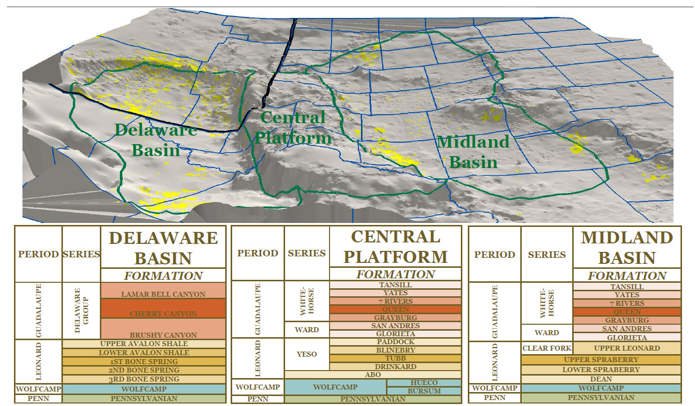
This 3 D of Midland Basin with counties overlain might help some one "get a feel" for the basin.
j richard said:
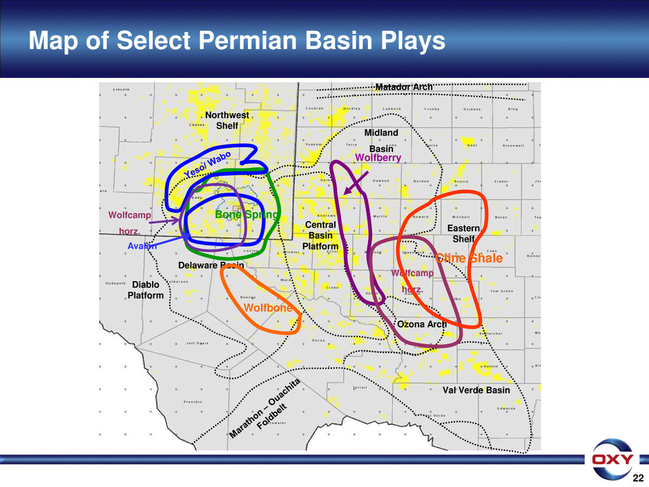
This graphic / schematic (I think it may be from Concho) shows the present day structure (although present day is very similar to ancient structure from over 200 Million years ago).
The yellow is most probably the operator's (e.g. Conchos) acreage position (yellow is typical color to indicate O&G operator acreage).
In West Texas, present day structure is very similar to the ancient structure that was first set up in Pennsylvanian time with the Permian Basin was broken up from a single basin into a split basin with a platform in the middle separating the two basins.
Craig Wascom said:
I really like this graphic and I think I am starting to get it. So I am going to ask what might be a really dumb question. Does the graphic represent the ancient sea basin and the yellow the deposits Przzz is talking about?
J we usually don't ask questions about a persons specific lease holdings and feel free not to answer. Are the wells on your holdings that have been completed considered Cline? If they are not and are shallower, I can understand how the definition of Cline would be of the utmost importance to you and all mineral owners in the same situation. I have said before I belive the only reason some companies are now refering to the Cline as Wolfcamp is because of the Pugh clause. If they have a completion in the upper Wolfcamp they would love to hold the Cline as the same field of production. If this is your case I can see how you would consider the answer to this question important news.
As mineral owners we need to push for an answer to this question. Our problem is the O&G companies have more juice with the RRC than we do, even though they are supposed to be protecting us. I encourage everyone to way in on this and I would love to hear suggestions on how we can push for an answer.
j richard said:
An excellent post for those that want to learn. Some consider this discussion not" news"- I beg to differ. In the Laredo September 2013 presentation turbidity seemed important to them on one of their slides. As for mineral rights. I want to know every thing I can about my minerals to the smallest detail. Wolfcamp or Cline? Is certainly relevant for vertical pugh clause, allowable and acreage designation from the Railroad Commission. Thank you for the post, I want to know more since this is an historical play. I mean Pioneer says it's number 2 behind Saudi Arabia.
Przzz said:It is the same yet different. And the lithology / thickness / mineralogy / thermal history / organic content / etc. varies across the Midland Basin north to south and east to west.
In the guts (deep) of the paleo Midland Basin (i.e. when these formations were deposited), one is looking a deep, quiet water area and low tidal / wave energy. Basically an enclosed basin in warm/ semi arid area. Not a lot of rain and evaporation is a key weather factor.
Deposition is a mix of sediment that is settling out from the water in the basin plus sediments being shed into the basin from the adjoining higher platforms and shelf areas that rim the basin.
Very fine grained sediment is the rule - siltstones and fine grained carbonates being deposited in a rhythmic sequence of layers over time. Silt, limestone, shales,mixes of all three aforementioned members, some organic rich, some organic poor. Thickness of individual zones varies from a few inches to tens of feet. And the areal extent of any one "depositional body" can range from a few acres to covering miles of area.
Biggest difference between the two formations is the age of the section. The Cline in Pennsylvanian in age while the Wolfcamp is younger (Permian).
This is thumb nail overview of the system. Obviously a lot more complexity than what is shown here.
I told you it was a dumb question.
Przzz said:
This graphic / schematic (I think it may be from Concho) shows the present day structure (although present day is very similar to ancient structure from over 200 Million years ago).
The yellow is most probably the operator's (e.g. Conchos) acreage position (yellow is typical color to indicate O&G operator acreage).
In West Texas, present day structure is very similar to the ancient structure that was first set up in Pennsylvanian time with the Permian Basin was broken up from a single basin into a split basin with a platform in the middle separating the two basins.
Craig Wascom said:I really like this graphic and I think I am starting to get it. So I am going to ask what might be a really dumb question. Does the graphic represent the ancient sea basin and the yellow the deposits Przzz is talking about?
I am happy to answer. My minerals are under the brand new Apache wells. They are vertical and all go to 10,500 ft to test the Fusselman. They passed through the Cline. One well is the only stand alone Fusselman for a few miles. The others are called Spaberry Trend and Wolfcamp, but no A B C D Wolfcamp. I don't think the Cline has been perforated. The Laredo Cox (which I think is their largest Cline horizontal) is 4 miles away. I hope Apache is going to drill a horizontal Cline with more study. They seem to be behind the curve as to Laredo. Yes, I think the Cline is a big deal. In fact these stacked zones in the Permian are a big deal.
Craig Wascom said:
J we usually don't ask questions about a persons specific lease holdings and feel free not to answer. Are the wells on your holdings that have been completed considered Cline? If they are not and are shallower, I can understand how the definition of Cline would be of the utmost importance to you and all mineral owners in the same situation. I have said before I belive the only reason some companies are now refering to the Cline as Wolfcamp is because of the Pugh clause. If they have a completion in the upper Wolfcamp they would love to hold the Cline as the same field of production. If this is your case I can see how you would consider the answer to this question important news.
As mineral owners we need to push for an answer to this question. Our problem is the O&G companies have more juice with the RRC than we do, even though they are supposed to be protecting us. I encourage everyone to way in on this and I would love to hear suggestions on how we can push for an answer.
j richard said:
An excellent post for those that want to learn. Some consider this discussion not" news"- I beg to differ. In the Laredo September 2013 presentation turbidity seemed important to them on one of their slides. As for mineral rights. I want to know every thing I can about my minerals to the smallest detail. Wolfcamp or Cline? Is certainly relevant for vertical pugh clause, allowable and acreage designation from the Railroad Commission. Thank you for the post, I want to know more since this is an historical play. I mean Pioneer says it's number 2 behind Saudi Arabia.
Przzz said:It is the same yet different. And the lithology / thickness / mineralogy / thermal history / organic content / etc. varies across the Midland Basin north to south and east to west.
In the guts (deep) of the paleo Midland Basin (i.e. when these formations were deposited), one is looking a deep, quiet water area and low tidal / wave energy. Basically an enclosed basin in warm/ semi arid area. Not a lot of rain and evaporation is a key weather factor.
Deposition is a mix of sediment that is settling out from the water in the basin plus sediments being shed into the basin from the adjoining higher platforms and shelf areas that rim the basin.
Very fine grained sediment is the rule - siltstones and fine grained carbonates being deposited in a rhythmic sequence of layers over time. Silt, limestone, shales,mixes of all three aforementioned members, some organic rich, some organic poor. Thickness of individual zones varies from a few inches to tens of feet. And the areal extent of any one "depositional body" can range from a few acres to covering miles of area.
Biggest difference between the two formations is the age of the section. The Cline in Pennsylvanian in age while the Wolfcamp is younger (Permian).
This is thumb nail overview of the system. Obviously a lot more complexity than what is shown here.
Congrats J!!! God has surely blessed your part of Texas.
j richard said:
I am happy to answer. My minerals are under the brand new Apache wells. They are vertical and all go to 10,500 ft to test the Fusselman. They passed through the Cline. One well is the only stand alone Fusselman for a few miles. The others are called Spaberry Trend and Wolfcamp, but no A B C D Wolfcamp. I don't think the Cline has been perforated. The Laredo Cox (which I think is their largest Cline horizontal) is 4 miles away. I hope Apache is going to drill a horizontal Cline with more study. They seem to be behind the curve as to Laredo. Yes, I think the Cline is a big deal. In fact these stacked zones in the Permian are a big deal.
Craig Wascom said:J we usually don't ask questions about a persons specific lease holdings and feel free not to answer. Are the wells on your holdings that have been completed considered Cline? If they are not and are shallower, I can understand how the definition of Cline would be of the utmost importance to you and all mineral owners in the same situation. I have said before I belive the only reason some companies are now refering to the Cline as Wolfcamp is because of the Pugh clause. If they have a completion in the upper Wolfcamp they would love to hold the Cline as the same field of production. If this is your case I can see how you would consider the answer to this question important news.
As mineral owners we need to push for an answer to this question. Our problem is the O&G companies have more juice with the RRC than we do, even though they are supposed to be protecting us. I encourage everyone to way in on this and I would love to hear suggestions on how we can push for an answer.
j richard said:
An excellent post for those that want to learn. Some consider this discussion not" news"- I beg to differ. In the Laredo September 2013 presentation turbidity seemed important to them on one of their slides. As for mineral rights. I want to know every thing I can about my minerals to the smallest detail. Wolfcamp or Cline? Is certainly relevant for vertical pugh clause, allowable and acreage designation from the Railroad Commission. Thank you for the post, I want to know more since this is an historical play. I mean Pioneer says it's number 2 behind Saudi Arabia.
Przzz said:It is the same yet different. And the lithology / thickness / mineralogy / thermal history / organic content / etc. varies across the Midland Basin north to south and east to west.
In the guts (deep) of the paleo Midland Basin (i.e. when these formations were deposited), one is looking a deep, quiet water area and low tidal / wave energy. Basically an enclosed basin in warm/ semi arid area. Not a lot of rain and evaporation is a key weather factor.
Deposition is a mix of sediment that is settling out from the water in the basin plus sediments being shed into the basin from the adjoining higher platforms and shelf areas that rim the basin.
Very fine grained sediment is the rule - siltstones and fine grained carbonates being deposited in a rhythmic sequence of layers over time. Silt, limestone, shales,mixes of all three aforementioned members, some organic rich, some organic poor. Thickness of individual zones varies from a few inches to tens of feet. And the areal extent of any one "depositional body" can range from a few acres to covering miles of area.
Biggest difference between the two formations is the age of the section. The Cline in Pennsylvanian in age while the Wolfcamp is younger (Permian).
This is thumb nail overview of the system. Obviously a lot more complexity than what is shown here.
What can we infer (if anything) from the 3D for Tom Green, Coke, Mitchell and Nolan counties? Thanks
j richard said:
Even though this 3D graphic is representative of present day structure, it is a very close representation of the strucutre at Penn (Cline) and Wolfcamp time. There has been some change over the past 200 million years in the shape of the Midland basin but this gives you a pretty good idea on the general shape of the Basin and Eastern Shelf (the key area in the counties you are referring to).
The key areas of Wolfcamp and Cline max desposition (and best protential productivity) are in the low areas of the Midland Basine onalductivpr The counties you are referring to are mostly out of the thick / low of the Midland Basin and more on the Eastern Shelf - thinner section due to less deposition.
Corresponding decrease in potential production in these areas.
Obviously there is a lot more complexity as to this whole situation, but the snap shot discussion above is a decent summary (IMO) of this situation.
Hope this addresses your inquiry.
Ralph T said:
What can we infer (if anything) from the 3D for Tom Green, Coke, Mitchell and Nolan counties? Thanks
j richard said:This 3 D of Midland Basin with counties overlain might help some one "get a feel" for the basin.
j richard said:
Thanks Przzz. That is what I suspected, less deposition in the areas outside the sweet spots that we are seeing in Glasscock and Midland Counties and possibly Reagan and Upton Counties.
Thanks j richard.
On the "Good, Bad and Ugly" board there is a RRC report from Devon Horizontal IP 4.5 miles west of Maryneal in southwestern Nolan County, showing 22 BBL on a 1000' foot horizontal from April 2013. That appears to be about the location of red line of the Eastern Shelf in Nolan County. That suggests to me that there isn't much going to happen in the current round of activity.
I would have thought the line would be a lot farther west, I am not surprised of that result that far east.
Ralph T said:
On the "Good, Bad and Ugly" board there is a RRC report from Devon Horizontal IP 4.5 miles west of Maryneal in southwestern Nolan County, showing 22 BBL on a 1000' foot horizontal from April 2013. That appears to be about the location of red line of the Eastern Shelf in Nolan County. That suggests to me that there isn't much going to happen in the current round of activity.
http://search.yahoo.com/search;_ylt=A0SO8x.y8a1SQV4AZnhXNyoA;_ylc=X1MDMjc2NjY3OQRfcgMyBGJjawMwbjdxNmhkOTVicTE4JTI2YiUzRDQlMjZkJTNEZEtSbUdGaHBZRUthVXhjU2ZQUC5PWWtoQlYxQk1Ob1NueWNsSVEtLSUyNnMlM0RmayUyNmklM0R2czNNSlI2Rlo2VTZ4T0RXamJHUwRjc3JjcHZpZAN5cXR4NU5CSExyNExuMGFMVWxYb0tBeGpNaG9iX2xLdDhiSUFBUDBOBGZyA3lmcC10LTk1MC1zBGZyMgNzYS1ncARncHJpZANYZDAxZW1wVFFGdTI1M1lGamd3cGNBBG10ZXN0aWQDQUQwMSUzRFNNRTM2NCUyNkFEU1JQJTNEU01FMzMxJTI2QVNTVCUzRFZJUDIwOCUyNk1TRlQlM0RTTUUzNjElMjZVSTAxJTNEVklQMDc3JTI2VU5JJTNEUkNGMDQ0BG5fcnNsdAMxMARuX3N1Z2cDMTAEb3JpZ2luA3NlYXJjaC55YWhvby5jb20EcG9zAzEEcHFzdHIDdmFsBHBxc3RybAMzBHFzdHJsAzIzBHF1ZXJ5A3ZhbCB2ZXJkZSBiYXNpbiBvdXRsaW5lBHRfc3RtcAMxMzg3MTMxNjM0MjA2BHZ0ZXN0aWQDVklQMDc3?p=val+verde+basin+outline&fr2=sb-top&fr=yfp-t-950-s USGS Report (hope this link works!) on pg. 22 & 38 a large amount of oil is shown around the Canyon sand/shale. A lot was bunched up around Howard-Glasscock field; but Howard-Glasscock is San Andres not Canyon. According to Laredo Cline is Pennsylvanian and Apache calls shale between Wolfcamp and Cline, Deadwood Shale. If this link works this paper is worthy of discussion; if not perhaps our moderator can get the paper to post.
Craig Wascom said:
I would have thought the line would be a lot farther west, I am not surprised of that result that far east.
Ralph T said:On the "Good, Bad and Ugly" board there is a RRC report from Devon Horizontal IP 4.5 miles west of Maryneal in southwestern Nolan County, showing 22 BBL on a 1000' foot horizontal from April 2013. That appears to be about the location of red line of the Eastern Shelf in Nolan County. That suggests to me that there isn't much going to happen in the current round of activity.