Continuing the discussion from Section 36-10N-19W:
John, I would think you are getting notices for 35-10N-19W. Looks like more activity like Section 25 & 36.
Also, Sister Sandra is looking to contact you if you get a chance.
http://imaging.occeweb.com/IMAGING/OAP.ASPX?casenum=201801082&casetype=CD
LOCATION OF WELLBORE (LATERAL) AT SECTION 26 COMPLETION INTERVAL: THE PROPOSED LOCATION OF THE END POINTS OF THE COMPLETION INTERVAL WILL BE NO CLOSER THAN 0 FEET FROM THE SOUTH LINE AND NO CLOSER THAN 330 FEET FROM THE NORTH LINE AND NO CLOSER THAN 1,320 FEET FROM THE EAST LINE OF SECTION 26, TOWNSHIP 10 NORTH, RANGE 19 WEST, WASHITA COUNTY, OKLAHOMA
LOCATION OF WELLBORE (LATERAL) AT SECTION 35 COMPLETION INTERVAL: THE PROPOSED LOCATION OF THE END POINTS OF THE COMPLETION INTERVAL WILL BE NO CLOSER THAN 0 FEET FROM THE NORTH LINE AND NO CLOSER THAN 330 FEET FROM THE SOUTH LINE AND NO CLOSER THAN 1,320 FEET FROM THE EAST LINE OF SECTION 35, TOWNSHIP 10 NORTH, RANGE 19 WEST, WASHITA COUNTY, OKLAHOMA
It looks like the Lima 26X35-10-19 2HB will run under the cemetery and south to Hwy 152, paralleling the Norma Jean 26-10-19 1HC.
How does running a well Lima 26x35 10N 19W in Section 26 and paralleling it beside Norma Jean well affect the production of well Norma Jean and the other 5 wells in Section 26? They have added this well to our Section and running lines into Section 35 saying they can estimate how much is coming from each Section?
The older vertical wells in section 26 are vertical wells in several zones.
The “Granite Wash” has many, many conventional reservoirs stacked like a cake. The wells targeted different ones. Their perforated zones were fairly thin considering that the wells are vertical .
The Norma Jean 26-10-19 1HC was targeted for a different zone at 12,957’. The actual perforations in the horizontal well were from 13,355-17,957 going horizontally once the well bore turned.
The operators conduct engineering tests on the currently flowing well and determine how much that well produce and how far away from the borehole the drainage extends. Think of a cigar shape. They will figure out where they can place the next borehole parallel to it, so that drainage pattern will just barely touch the first one. Then they will place the next one parallel to that one. Think of cigars in a layer in a box.
Thank you, what about production of Norma Jean with new well? Do you know if they have started the drilling of the Lima well?
The production of Norma Jean will have a natural decline. When the drill the new well, they will shut down the Norma Jean to protect it while they frac the new well. It will hopefully come back just fine.
You will be able to track any new spuds from section 23 in the OCC well records site.
Test. The surface is not always in one of the main sections. I do not see a permit for the well yet and do not see it listed on the OCC well record site. So it has not spud.
Terry, just getting your message. Yes, we’ve been getting notices on 35-10-19. I keep calling the land agent to get an idea of progress/activity, but no return calls or communications. If Sandra needs to reach me, my email is jhclaytonesq@gmail.com and my phone is 651-587-0320. Hope all is well out your way.
John
Norma Jean produces 1/3 normal for this last month January. Are they cutting back now for drilling of Lima?
I do not know. At some point, they will shut it in briefly while they frac the other well.
Has there been any movement on drilling well in 26x35-10N-19W? Last information I received was in February on approval from Corporation Commission?
Looks like the pad for the 26 well is in section 23. The pad for the 35 well is in 2-9N-19W. I see a Norma Jean 26-10-19 1HC completed in 2018, but I don’t see production. Looks like a new well might be called Lima 26X35-10-19 2HB, but not seeing it finished with all the paperwork yet or a permit.
I see a permit for 35 called the Lima 35-10-19 1HC posted on April 2, 2019. Not spud as of 5/2/19. Not all of the cases are finished for that section.
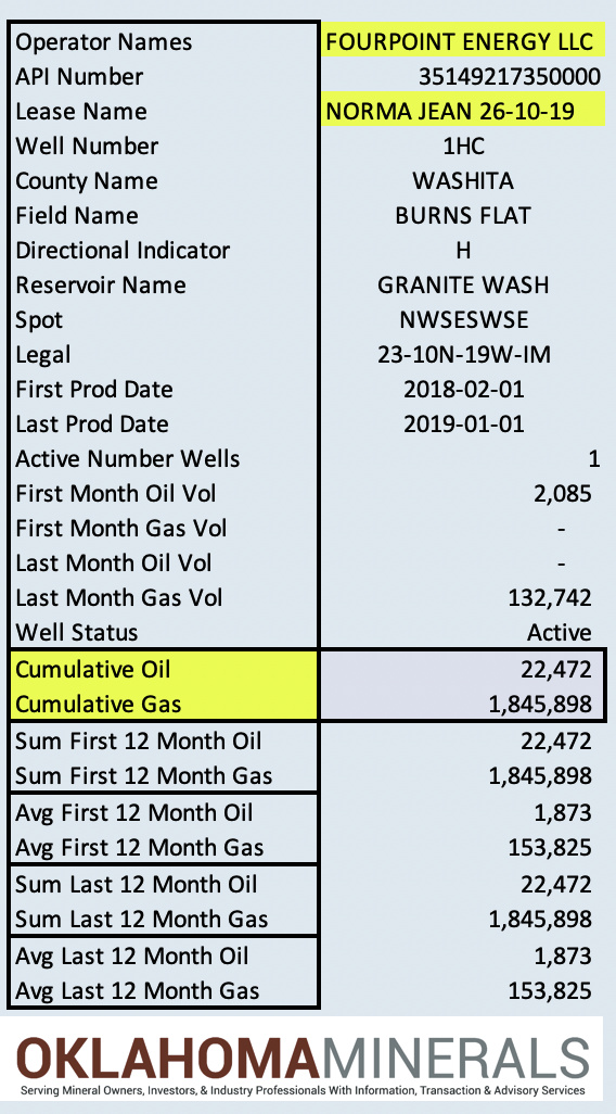
Here is the production (attached) for the Norma Jean 26-10-19 1HC.
1 Like
Talked to Four Point; they said Lima is 26x35 10N 19W and said they should be online soon. I have a question: I have mineral deeds to property in other counties but it does not give amount of acres on deeds, just descriptions and percentages. How do I find out what I have in each county and if it has already been drilled or has a lease in the past?
Those deeds can tell you the acres. The description is the key. By knowing the section, township and range, plus the aliquots (The NW4 of SE4, etc. ) and the percentages, you can figure it out. If you give an example, I can walk you through it.
You can search most of the OK counties on the www.okcountyrecords.com website for free. The digital files go back to the early 1990s for most counties. The other counties have their own websites (most of them).
If you have questions after you look those up, you can use the forum.
Also get to know the Oklahoma Corporation website. It is free and has quite a bit of useful information.
Thank you! I will get you one of the legal descriptions when I get back to the office.
Here what it says, an undivided 1/6 of 1/16 mineral interest in SE/4 of Section 13, Township 15 North, Range 26 West, Roger Mills County, State of Oklahoma. How do you read this to get mineral acres in section and?
You read them backwards. Section 13 has 640 acres. The SE4 has 160 acres. 1/16th of 160 acres is 10 acres and 1/6th of 10 acres is 1.66666667 acres if I did the math right. Some deeds are nice and spell out the number of acres.
Thank you, so what would be S/2 SW/4 of Section 26?
Sorry, is that 160 + 160 = 320 of Section 26?
Here one undivided 1/6th of 31/32 of 155 acres in E/2 W/2 and NE/4 of Section 35?
In general, each section has 640 acres. The 1-6 tier and the 6,7,18,19,30,31 sections may have adjustments for the curvature of the earth. You can find the original patent maps at Search - BLM GLO Records. Use the LSR choice for OK. Occasional a river requires new calculations if it moves (which they tend to do).
s/2 sw/4 of section 26. would be an original 640 acres and read from right to left. SW4 is 160 acres and the S2 would be 80 acres. You probably have a fraction of that at this point of generations handing down, but maybe not.
“sorry is that 160+160=320 of section 26”- See my previous answer 1/4th of 640 is 160 and 1/2 of 160 is 80. You probably have a fraction on this one.
“Here one undivided 1/6th of 31/32 of 155acres in E/2 W/2and NE/4 of section 35?” This one is a bit more complicated. Section 35 has 640 acres. the NE4 has 160 acres. The E2 W2 has 160 acres, so someone reserved something out. The clue may be the 155 acres, so using that, 31/32 of 155 acres is 150.15625 acres and divided by 6 gives 25.0260417. I think this one may have really meant that the original 160 acres was divided into 32, 5 acre pieces and that would give 25.83333 acres. This one is a bit unclear. The punctuation matters. If the 1/6 of 31/32 only goes with the first part, E/2 W2 or includes the rest with the NE4. I would have to see the deed. If there is an extra comma or semi-colon.
Here is a good article to help you understand.
S-T-R Legal Land Descriptions in OK_Kletke-1.pdf (59.7 KB)