Greetings, all. I have leased my mineral rights to an oil company which is currently producing two oil wells and one gas well in Anderson County. The deed I have for the property is from 1929 and uses a very old-fashioned and cryptic property description with no clear way to locate it on the map (e.g., lat/long).
By going backwards from the oil drilling lease agreement, I have been able to identify the property to be one of eight possibilities in the A-73, Anderson County School Survey. Each property appears to have some identification numbers that I don’t know how to decode.
Here is a specific example of one of the property numbers:
What is the LATS number? It looks like an APN number but I am not sure. Will it help me to physically locate the property? What about the compartment numbers? Are these sub-divisions? I am guessing about all of this right now.
Also, assuming this is a red herring and doesn’t help me locate the property, how would you go about finding out that information? I have done a little forward-and-backward title searching, but so far all I have found is the old-fashioned description.
Thanks for any clue or helpful comments you might have.
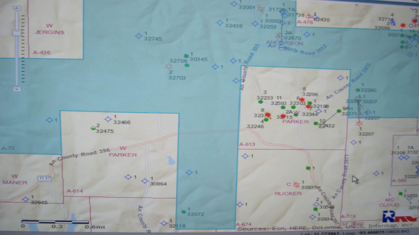
This won’t help with the LATS numbers but it will show the layout of the survey and producing wells.
Note that this is a strangely shaped survey that covers a lot of area. The red and green dots are producing wells - list of these shows none are presently active.
But also notice the black dots in the NE part of the survey have no associated API numbers and may be the core of the circa 1930 area that your leases may be tied to. Definitely some old wells if Drilling Info (my source) is not picking them up.
But they also are probably not active (since DI would have picked up any active well regardless of age).
All the other well symbols are dry holes.
Tx RRC GIS site may be the best bet to find out more about what you are seeking
Looking closer at the LATS, these appear to be API numbers.
The first part (42-001) is the state (Tx 42) and County code (Anderson 001). The last five numbers are the specific well ID. All start in “0” meaning “old well”. The list attached has wells that begin with “3”.
This probably means that the unnumbered black dots in the NE part of the survey are the ones you are looking for. Tx RRC will have API numbers for these in their GIS map site.
Yes, our wells are on the top of your list which are leased to BBC&D. They are part of our lease area, but not necessarily sitting directly on our property (in fact, probably not).
If I knew exactly where the property was on the map, I could determine what portion resides within the lease area. That way I can determine what percent interest I am due.
I didn’t mention this because I didn’t want to complicate the discussion, but BBC&D is not allocating the amount of interest we expect to receive. They are saying we only have ~1/8 interest and the 1929 deed shows we have 3/4 interest.
Yes, Rock, you are honing right in. This is the lease area and our property (~40 acres) is supposed to be part of it according to the BBC&D agent. So pretty much what I’m trying to do is identify exactly where my property or any other leased property is located on this map.
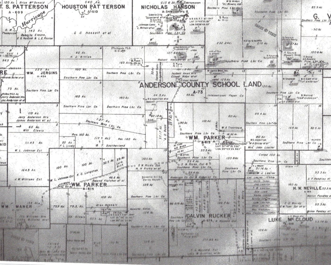
Please tell me if you can what the TOBIN map might show me? I don’t mind paying if it would be of use.
Raymond and Rock Man, I have surface and mineral interest about six miles northwest of the Sewell well in the Bledsoe survey of Anderson County and the Sewell well was reported not to be very good. But a few months ago there was some increased leasing activity in that area so we are hoping things will turn around soon. I recognized very quickly your sample Tobin map of Howard and Dawson counties as I have mineral interest on two unleased places in Dawson County also. I have watched the up and down oil prices for 60 years and it has always come back, and it will again. John
Mineral, I am very interested in any possibility of getting plat map for the property. What is the Appraisal district? Sorry I am not familiar with that acronym. In order for them to provide map, what kind of ID information would they need? I have nothing to go on now except the old-fashioned description, but I might be able to get more information if I knew where to look. Kind of a chicken-egg problem.
Mr. Copeland, You can do a Google Search for the Anderson County, Texas Appraisal District and you should be able to get their number and start from there.
It is reasonable to assume that if they are trying to lease or buy minerals at a time like this in the Oil Business that something must be really good.
No, unfortunately I live in San Jose, CA, and have to do all this remotely. I have made some contact with the courthouse but they just recommend I contract a landman. I may do this, but first I want to learn as much as I can on my own. It seems like one of the most basic things is to find out exactly where the surface property is located.
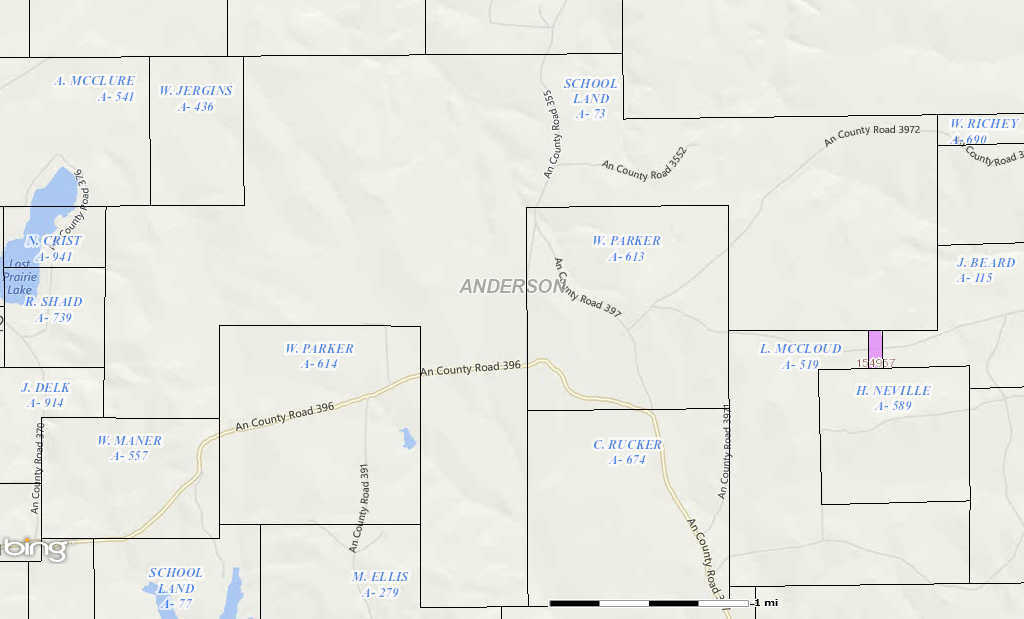
We have owned the 640 acre Bledsoe survey for 45 years and it being one square mile, I can estimate the Anderson County School survey where the Sewell well is located to be 7 or 8 miles east of Palestine with about a 10 degree variance to the NE. Our land is about 6 miles NW of your interest. I have a large Anderson County survey map and they can be ordered from the Texas General Land Office (1-800-998-4456) for $15 plus postage. There are probably 6 or 8 Anderson County School surveys scattered about the county but with different survey numbers. Triad and Hou-Tex are leasing companies who in the last few months leased mineral acreage in that area and I am interested to know if they leased your interest. If not, would you mind telling me who did? Thanks, John
John, it is good to know I can purchase the survey map. I will call the land office right after this and order one. As mentioned above, we are leasing to BBC&D and they have been producing since 2012.
You are exactly right about the location of our well (one of two). Also, what abstract are you in? I was looking for your property using Google Earth Texas Survey.
Thanks, Clint. Yes, I have been using the RRC viewer for some time and it is very helpful, especially for tracking well logs. But unfortunately, it has not helped me to pinpoint the property which is my current objective.