Does anyone know if there is any activity in this area? I own mineral rights but live far away from there, any comments would be helpful.
Last October, One Energy permitted 4 wells in Section 18 and several wells to the northwest of Section 7. I do not know the status of these wells. I heard that One Energy might be selling its leases. There are other wells to the west. This area has become quite active.
Thanks, that was most helpful and encouraging. Is there a site I can get that information myself?
Can anyone give me any status here? I have interests as shown in the title, leased to Blackbeard Operations over 8 months ago. Just curious if Blackbeard is drilling anywhere in that area. Is there a web site that I can check up on Blackbeard and their drilling activity?
New Mexico Oil Conservation Division. From home pages, OCD online and Imaging to look at well files by using your Section, Township, Range, County. Or by operator in the county. Look at the Case Files to see if your operator has filed for compulsory pooling order or other cases. Or from home page, use OCD GIS to look at the maps for wells in the area. You can also call Blackbeard and ask the landman in that area about any plans. It is possible that wells will be permitted and Blackbeard will not be the operator, but instead a non-operating working interest. Or Blackbeard can assign your lease to another oil company.
Now THAT is what I have been looking for! Thank you TennisDaze, that should keep me busy for some time now! I actually did not know that much information existed. As usual, it has brought up another question. I had grown accustomed to the break of a section into like S2 SE4, etc. Now I find first off apparently there is also an alphabet squares of location, and now this one that totally stumps me: What is this FSL and FEL stuff? Surface Location: O-18-25S-36E 380 FSL 2260 FEL
1 Like
FSL = From South Line. Meaning from south line of the section or tract. The description tells you the location of the well, as 380 feet from south line and 2260 feet from east line.
2 Likes
Well duh! I suspected something like that, but was trying to use more hi tech words and failed. I am progressing well with my attempts to speak the “oil-wellian” language, but so far have only acquired a slight working knowledge.
2 Likes
Well here is another one for the experts: I found a couple of producing wells on our lease today, and in checking them out found that one had produced 19,509 barrels of oil in 2017, and surprise: 162,027 barrels of water! I had read about a shortage of water in the Permian, but obviously not from this well. My question is since they could not drink that much water, does it have a value? Do they sell the excess? How much is needed for production?
I have had a couple of generous cash offers for the rights in the subject of this thread. Is that just routine or does it indicate that perhaps someone has knowledge of oil and drilling? I am still not quite good enough to look up permits and such.
Don - Any updates on your situation?
The OCD’s GIS map should help you keep track of activity. Here is the link:
As near as I can tell, they are avoiding my area, T25S, R36E, SE quarter of Section 7 and NE corner of Section 18. I guess there might be some horizontal drilling but I am not able to find that either.
1 Like
Don,
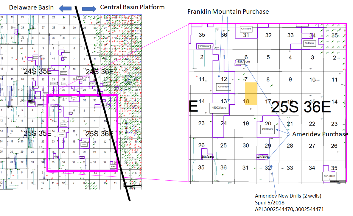
Not sure if any of this helps. Here is a map showing wells and where your leases are, which is getting on the edge of the Delaware Basin.
Purple shapes are leases that the BLM just sold in Sept. With lease pricing. You can see (assuming you can read my tiny print) that lease pricing goes from quite high (40-50k/acre) in the east of 25S 35E down to basically zero (300 to 500/acre) on the east of 25S 36E… the closer you get to the basin edge. Basin edge is a risky area that might go from fine to crap over just a mile or two. Franklin Mtn (whoever that is) bought parcels just to the West of your acreage for 42k and 45k. They have a lot of time, but somebody is going to drill some wells there after those purchase prices. Ameridev bought leases just to the East of you for 12-22k per acre. Ameridev also drilled two horizontal wells in the South of 25S 36E this year. So they look to be trying to prove up the middle part of 25S 36E.
Short story long. Nothing happening on your acreage now. I’d expect to see drilling continue to move East out of 25S 35E and into 25S 36E. Hang tight and enjoy the ride.
Cheers
Thank you so much, that is indeed VERY helpful! For what it is worth, we are leased to Blackbeard Operations for just over a year now. Recently received a cash offer from McMullen Minerals to buy for $22,550 per NMA (Section 7 only). Knowing almost nothing about the business, it does look encouraging to see Franklin Mountain and Ameridev making a sandwich out of our minerals. If they strike it rich it could not help but increase the value of ours, right? Could either of them possibly put a horizontal drill into our minerals?
I’d guess that $22,550 per NMA or $11,275 per NRA is a little low. Not crazy low. It’s low if your acreage is productive like it is to the West. But it’s way too high if it’s not productive at all. It’s all a risk business. That’s half the fun of it.
Barring oil going completely in the tank, I think it’s clear that people will drill horizontal wells by your acreage and will prove it up one way or the other. There are logs across the Wolfcamp and the Bone Spring (your horizontal drilling targets) in old wells in Section 18, Section 8, and Section 17. (By “logs” I mean they drilled a vertical well to deeper depths and ran electronic/radioactive tools in the hole; these are 1960 vintage wells but they should at least be able to tell if the zone is there and how thick). So you’d guess that people paying for leases in this Township have some positive vibes about the potential of those zones. You got to be pretty confident to pay $45k bonuses to the Feds in the adjoining sections. That’s big boy $. The BLM leases are for 10 years though, so it may take a while. But if Ameridev hits on the wells they have drilled, they should drill more, etc.
As far as on your acreage, one would guess if Blackbeard has a big enough position there then they will try to drill a well before leases expire (assume in 2 years plus perhaps extension). Email Kaleb or Kareem at Blackbeard and ask them if they are going to drill a well anytime soon. They are reasonable guys, they’d probably tell you. info@blackbeardoperating.com
1 Like
NMoilboy: is that an OCC map or some private service?
Well that was fast response, Blackbeard responded that they had sold the leases to get this: Ameredev! So I am not sandwiched between Ameredev controlled areas, I am actually part of it! I think I like that a lot!
Kathy, private/subscription through IHS.
Don, sounds great good luck.
Anyone know about EOG and Concho plans in Township 25S Range 33E Lea County. I have 2100 gross acres in 4 different sections. Anyone had any offers in that area?
Can anyone provide information on activity in Section 17, 18 Township 24 South Range 32 East & Sections 3, 4, 9 & 11, Township 24 South Range 32 East? We have an override that includes those lands. I understand that has been a good horizontal area.