My wife has some interest in 7-19-26 Eddy County. A year or two ago Percussion was the operator. Spur did extend the lease in April 2022 but there has not been much activity. I was under the impression that they were financially solid but when I check the weekly well activity there is very little going on with Spur in Eddy County (or anywhere for that matter). Does anyone know what they are up to? NMoilboy did say they only have one rig operating in Eddy. But lots of leases. I wonder why, at these prices.
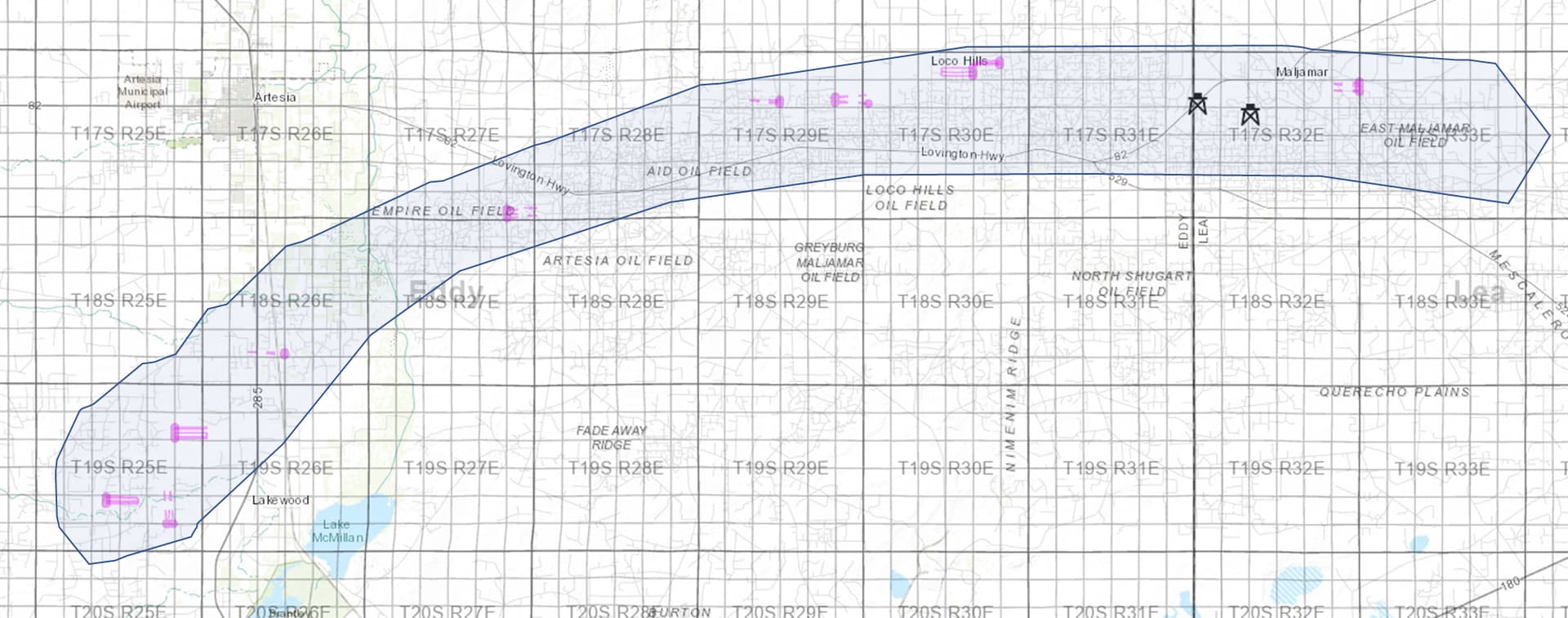
They now have 2 rigs (shown below). They’ve drilled 39 wells in the last 2 years (pink lines below). All in the Yeso trend which is sort of the blue shaded area. They don’t own all of that, but they should have a good chunk.
I do agree, it seems like they will have a hard time holding all their acreage if they don’t get a bit more busy. You’d assume a lot of that Percussion and maybe some of the COG acreage is going to be expiring. But I don’t know.
They probably have 10-20 years of drilling inventory at this pace. I totally get it, it’s hard to live a 10-20 year development one weekly activity report at a time, but it’s a patience game.
Thanks for the info. I made a mistake in the location. It is Section 7, Township 19S, Range 25E. Looking at your map, this is just outside the established Yeso trend. Digging a little deeper, Spur has proposed ten wells starting in Section 6 and ending in Section 7. Seems like they may think there is oil on the edge of the trend. There is some seismic data in the application on the OCD web site but I don’t know how to read it.
Sorry, the Yeso trend pic was more a cartoon than science. Here is a map from when Percussion was trying to sell this acreage (to Spur), note Section 7 in their “Core” (pink arrow). I would assume you will be fine, may just take a while.
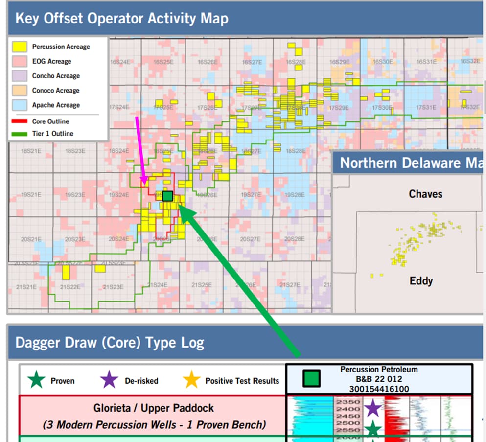
Thanks! I looked up the production history of the B&B 22 well shown as proven. Looks like it is reasonably productive, both O&G. Not sure how it compares to other wells in the area. Just have to be patient. Thanks again.
Spur Energy sent a compulsory pooling order for our unleased interest in Section 18-T18S, Range 27E, Eddy County, New Mexico. We have been trying unsuccessfully to negotiate a lease over the course of the last year to no avail. Their pooling order stipulates 5 wells to be drilled, the Baffin wells.
We really don’t want to be unleased nor turn the interest into a working interest. The 200% risk charge doesn’t sound that good either. What to do? Current offer is $1,000 per net mineral acre, 1/5th royalty, and three-year term on their lease form. Spur isn’t too interested in negotiating lease terms.
Based on the map NMoilboy so kindly posted, it looks like your holding is outside their most important area. My guess is they won’t negotiate because they have a lot of acreage they need to drill in their core area first, but NMoilboy may have some more informed thoughts.
They won’t negotiate because they have made what they can probably demonstrate is an acceptable offer (It may not be what you want, but I’m sure people around there have accepted it) AND they are probably happy if you get force pooled.
If the hearing hasn’t happened yet then get on the docket to protest what you feel is a lowball bonus offer. Or use threat of protest to negotiate. Otherwise you sign the lease. Yesterday. The law is set up to keep people who won’t lease from holding up drilling. Lease or get run over. Seems unfair, but everybody should be used to it by now.
That acreage is fine. If they drill wells you will kill it on the royalty per acre at 20%. If not, well then you get to try again in 3 years (from whenever you sign this lease).
Thanks for your reply NMoilboy… much obliged.
Justinfo,
We have interests in Section 7-19S-26E, Section 8-19S-26E, and Section 12-19S-25E. Several years ago (2015-6?) we leased with Concho and Percussion and then all of this was purchased by SPUR. So I am wondering why your wife’s interests were not picked up at the same time?? We are currently receiving royalties from Rose 2H-8H Wells in Section 7-19S-25E. I don’t quite understand why Spur/Percussion/Concho didn’t lease with you then. But then there is probably a lot I don’t understand about this system.
Wishing you and family the best with your interests. Hang in there.
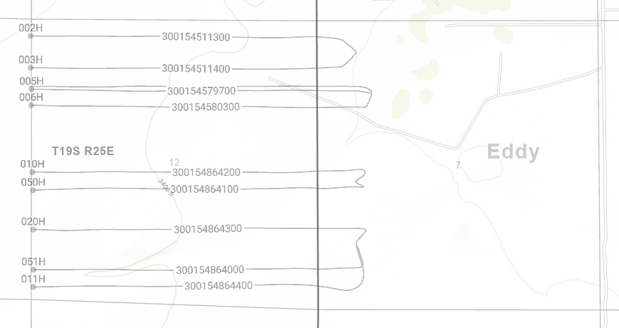
The Rose wells’ surface location is in 19S26E Section 7. The actual acreage getting paid on those is 19S25E Section 12. There is nothing producing in either 19S26E Section 7 or 19S25E Section 7.
Justinfo, Just saw your correction to the location of your interests. So, forget my question. Nonetheless, good luck.
I was thinking about the Spur lease on Township 7-19S-25E again. I have a 1/4 royalty agreement offered by Percussion. It expires in a bit less than two years. I notice that some of the other leases on this acreage are at 1/5 royalty. I wonder if Spur is going to let my lease expire and then offer me 1/5. I don’t see that I have much leverage at that point. With so much acreage I am sure they have a sophisticated model on how and when to lease/drill to optimize their returns.
That’s possible. I doubt their driving force on decisions is going to be to wait out a partial interest owner to save 5% on royalty. But they may not get around to drilling those Trudy wells before your lease expires and you may get (another bonus and) a lower royalty offer in that case.
NMoilby, I have been meaning to ask this question for a few weeks but needed to go back and look at receipts to see what they state. Also had to look at pictures we took while on site a few years ago. So you say that the surface location of the Rose wells is in Section 7-19S-26E but the actual production is coming from Section 12-19S-25E. I can see that. But where is the Bradley 8 Fee 5H? I thought at first maybe it is just the location of gas gathering and compression but our receipts tell us there is oil production as well. I assumed the Bradley 8 was on Section 8-19S-26E.
When we were on site we saw tanks, gas lines, flaring stacks, and oil pumps all over. We tried our best to determine where everything is actually located. Looking at signs at each site and looking at a map from the assessor’s office. But hard to tell where the section lines are while standing among sagebrush, fences, and equipment scattered all over. ![]()
I tried my best to study your detailed maps. BTW, thanks for sharing all that information. Great stuff. So, where in the heck is the Bradley 8?
Here is all the info you could possibly want on the well. BTW, it seems to be in the SW corner of the block. OCD Permitting - Well Details
The Bradley Fees are all across Section 8. There are a bunch of them. The 5H is in the western portion of Section 8.
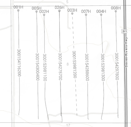
Here are the Rose wells, surface in Section 7 but producing from Section 12. Doesn’t look like any perforations in Section 7.
Thanks to NMOilboy and Justinfo. I will study this information.
Wow! Good stuff. Thanks again. Now I just need to figure out where NMOilboy gets those maps. Is that on NM OCD site also?
That was from Drillinginfo/Enverus which costs quite a bit but I have access for work-ish things.