Hopefully you can see my image I put here. Anyway, I have interests in Section 35, Township 4N, Range 4W and I see Marathon just got permits to drill. What I am not sure of, are these wells going horizontally across my Section 35 or across Section 34? I am sure hoping Section 35! I know someone will know for sure. I wish I had maps for these wells to know for sure. Thanks, Tom.
Arkomo, look at the permit and it will show the end point of the wells under Horizontal Well 1. They are both in 35. One is Mississippian and the other Woodford and both just under a mile long. Someone else could inform us what the radius of turn and direction mean.
Mr. Foley: This is only shown for horizontal wells. The radius of the turn refers to the radius of the turn from the vertical drill hole to the horizontal drill hole of the well. The direction is the direction in degrees of the horizontal hole from the vertical hole (0 to 360 degrees, i.e., 180 is approximately south).
Caliope, the radius of turn on both of these wells is 462. The directions are 10 and 15. What does that say?
You can look them up by name on the OCC Wellrecords site. Look for the surface location or type in the name. Form 1000 is the permit. Usually, they have a map at the end that shows the path of the well. If not, you can read the permit and it will tell you where it will start and end.
http://imaging.occeweb.com/imaging/OGWellRecords.aspx
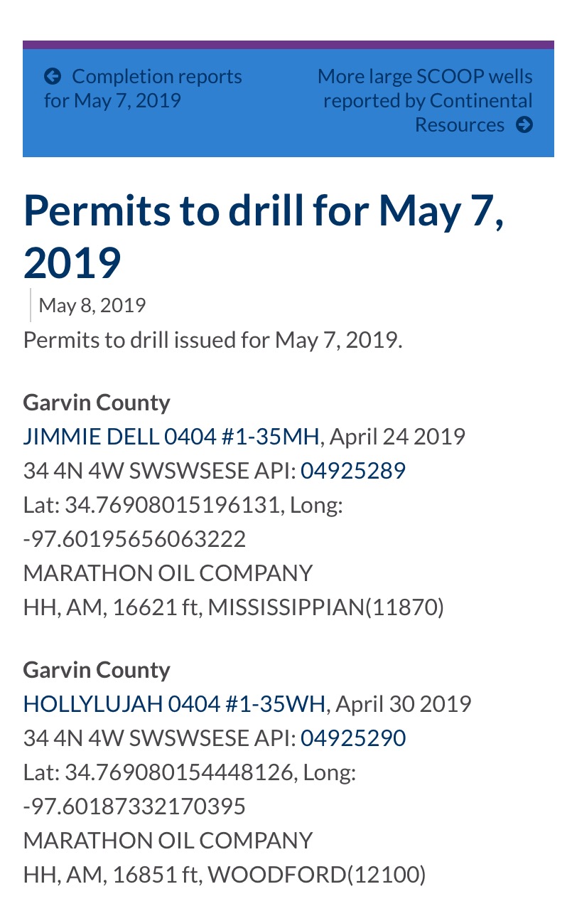
The surface locations for each well are on the same pad, in the SE corner of SE/4 of Section 34. Both wells will drill easterly into the SW/4 of Section 35 while drilling down to their intended formation target, before turning north to the NW/4 NW/4 NW/4 of Section 35. The Hollylujah #1-35WH is a “Woodford horizontal” while the JimmieDell #1-35MH is a “Mississippi horizontal.” You can disregard any mention of radius or direction.
1 Like
Thank you to all that have responded! This is exciting news! Tom
On a well like this where they are going to drill two wells, one in the Mississippian layer and one in the Woodford layer, I know they spud on May 27th and 29th. I know there is no exact timeline, but can you give me an idea of when I should receive a division order and then my first check?
I also have a well called Prairie that is in Garvin Section 33 4N4W that I see is now active. It was spud in October. Should I expect anything soon on it? Thank you for your expertise! Tom
In general, a one section well takes about three - four months to drill and complete. A two section well takes about four-five months to complete. You should get a Division Order “about” five months after first sales, perhaps longer for a two section well since there are hundreds of titles to check in each section. By statute, you are supposed to be paid six months after first sales if you have clear title. If they do not pay, then they owe you 12% interest by statute. If your title needs to be cured, then they owe less interest. A small caveat is if your first sales date misses the check cut date for a company, the date may slide to the next check cut date. I don’t usually start to investigate until seven months after first sales.
Also, when they are drilling two at about the same time, they often wait and frac them both at the same time to save money on the crew and process.
It may be a dumb question but how do I find out when the first sales date was? I saw on the tax site that my Section 33 was active. Is there a way to find out when it actually went active, and from active date normally how long till first sales date? Thanks much. Tom
Most of the time on my wells, the active date has been the first sales date within about two days.
Mrs. Barnes is there a way you can help me get on paydeck for a well in Garvin County? Not sure how to contact you directly on new version of this forum???
If you are past the six months from first sales, then contact the operator directly with a certified return receipt letter. Give your name, address, phone number, legal description of your minerals, name of the well and ask for when the division order will be going out. Also ask if there is a cloud on your title that is preventing you from being in pay status. Ask what you need to do to clear it.
6-1N-2W in Garvin. I had a landman tell me we were owed money on a well that was producing but not paying? Anyway I can get someone to research and get me paid on that well?
You don’t have to get someone else to do it. Look up the section, township and range on the OCC wellrecords site. There are 28 wells in that section. Many of them quite producing a long time ago. The two that are still online are the Mary Beth 1-6 and the Jeanne 1-6. Cimarex is the operator right now. I printed out the permit header for the Mary Beth 1-6. It gives the operator address.
http://imaging.occeweb.com/imaging/OGWellRecords.aspx
Operator: CIMAREX ENERGY CO Lease Name: MARY BETH Operator Address: 202 S CHEYENNE AVE STE 1000 TULSA, OK 74103-3001 Well #: 1-6 Mud System: Contact Name: SHARON LAVALLEY Ground Elevation: 986.0 Contact Phone: 918-585-1100 Total Depth: 11,416 Approval Date: APR 9, 2018 Start Date: APR 9, 2018
I receive royalty payments from Cimarex in this area but not from these wells. I really don’t mind hiring someone to get me on the paydeck for these wells. I also have some stuff in Stephens that has never paid me. I don’t know why it is so hard to get paid on these???
Much cheaper to contact the operator directly. They will only deal with a mineral owner and that is free. What well did the sandman mention and what is your complete legal in that section. Perhaps there is a different well that you need.
If you post your Stephens acreage in the Stephens forum, I can look up the wells there.
Note that any wells that are productive will only pay out to those mineral owners that are in the spacing unit for that well. For example, if you have acres in the NW4, but the well is in the SE4 and only spaced at 80 acres, then you would not be eligible to get paid.
Arkoma I see the gross production site has the active date as Dec. 29, 2018 so the six months is just about up. Well reports from OK Energy Today publishes drilling permits and completion reports as they are issued and filed. June 3, the Foster 1-8-5MXH was published. It has a completion date of June 8, 2018 and a 1st production date of July 11, 2018. Casillas (drilled the Foster and the Prairie) had two more completion reports issued on June 4. The Stripe 1-33-28WXH in 3N, 3W with a completion date of Sept. 10, 2018 and 1st production of Dec. 5, 2018. The Culebra 1-10-15WXH with completion date of Oct. 15, 2018 and 1st production of Nov. 19, 2018. If the Foster well reporting is the clue we could wait another six months. On the other hand they have filed 4 completion reports in a week’s time. The Prairie is getting closer to the top of the pile.
Thank you Sir. I am getting excited about the drilling.