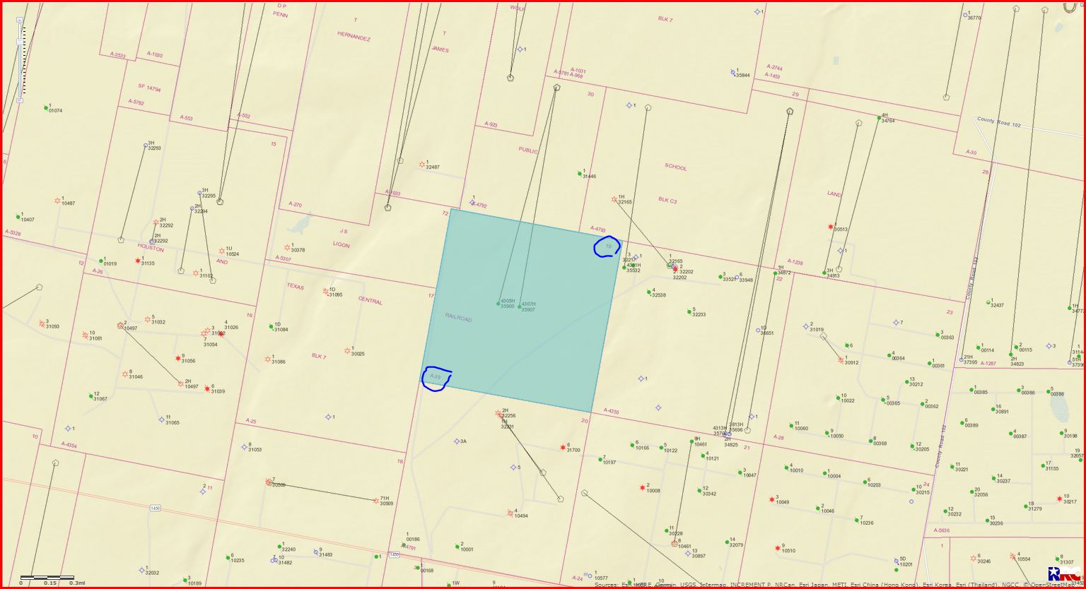
My property is in Section 19; Block 7; H&G RR Survey; A39.
There are 2 horizontal wells drilled by Parsley Energy that also include land in Sections 6 and 30.
I am looking for a map that shows all the areas around Section 19.
Now that oil has gone up to over $50/barrel, I’m wondering if Parsley Energy may start drilling again. Does anyone know how many wells could be drilled on my property? I was told 5 but later read it could be more.
Thanks for any input.
Susan Titus
So sorry, I listed Section 6 but meant Section 7.
Hopefully this map will help you. Reeves County Section 19/Block 7/A-39
DOUBLE LEFT CLICK ON MAP TO ENLARGE
Clint,
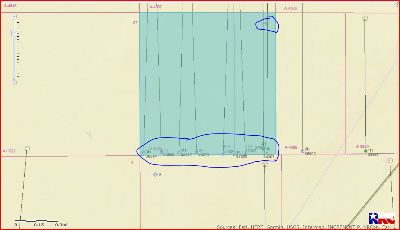
Would you mind sending me what is happening in Section 28 Block C-1?
I have some interest in that section and am receiving royalties from Tiger 21 #1H and Tiger 21 A #2. I heard some new wells are working in 28. Is that true?
A map would be great.
Thanks,
John
John, this link will show you all approved permits for ‘Tiger Unit’ wells for Reeves County. Use the API well numbers on the GIS map to find the Tiger wells for Section 28 and then click on the lease name and you can view the permit at the top to tell if the well has been spud (begun drilling) yet.
2 pages/13 approved permits
http://webapps2.rrc.state.tx.us/EWA/drillingPermitsQueryAction.do?pager.pageSize=10&pager.offset=0&methodToCall=search&searchArgs.paramValue=
GIS map of Reeves County Section 28/Block C-1/A-1223:
DOUBLE LEFT CLICK TO ENLARGE MAP
This link is to all production on Lease #46187/Tiger Unit 21/API 389-34307 from October 2014 through October 2018. Manipulate the beginning ‘Date Range’ back to October 2014 and click Submit to view all production on this well.
http://webapps2.rrc.texas.gov/EWA/specificLeaseQueryAction.do?tab=init&viewType=prodAndTotalDisp&methodToCall=fromGisViewer&pdqSearchArgs.paramValue=
This link is to production data on Tiger 21A 2H/Lease #50693/API 389-36812:
http://webapps2.rrc.texas.gov/EWA/specificLeaseQueryAction.do?tab=init&viewType=prodAndTotalDisp&methodToCall=fromGisViewer&pdqSearchArgs.paramValue=
Why would we not be getting royalties from the other wells? If we have 6 acres of minerals, should we get minerals no matter where they drill in the Section?
Clint has shown you how to start researching information to build personal records about your minerals. First, a lease file with lease (original and recorded), correspondence (including printed emails), and copy and print answers from the forum. Watch the county deed records for lease assignments, whether 100% or partial, and add those so you know what company or companies own your lease.
Second, well files - preferably a separate folder for each well. Print permit records, completion reports, plats, division orders, etc. You have to watch the permits to see when the information box opens to let you know the well has been spudded. Note that Clint’s permit list includes wells that have been spud and others that have not been spud and one filing is field transfer. Some permitted wells are never drilled. Some companies wait months before fracking so multiple wells can be fracked at the same time. So keep watching RRC Completions filings. Look at Texas Comptroller CONG system to see volumes and sales and you can compare to your check data.
Third, unit files with copies of the Declaration of Pool Unit and amendments. If you are asked to ratify, keep a copy and add any county recording information once it is filed. Same if you ratify a production sharing agreement. Read before signing and see if the DPU or other document amends your lease terms and if that is okay. Join NARO and read the newsletters, including back issues. Attend a Texas or national convention for the seminars. Read John McFarland’s Oil and Gas Lawyer Blog, current and past postings.
2 Likes
I think only two wells are active; the rest are permits. Birds in hand vs those in bush.
The permit links/info will show you what acres are dedicated to what wells. You can then see if your 6 acres are in the wells. Yeah, if your 6 acres represents 6/640 interest of the whole section then you will receive a portion of any producing well that penetrates Section 6. It may be that the acreage dedication is all of Section 6 in which case you get to the same place, interest in every well.
Excellent advice. Good records are a gift you give yourself, your accountant and your children.
Also, be sure and put your mineral rights into your estate planning specifically!
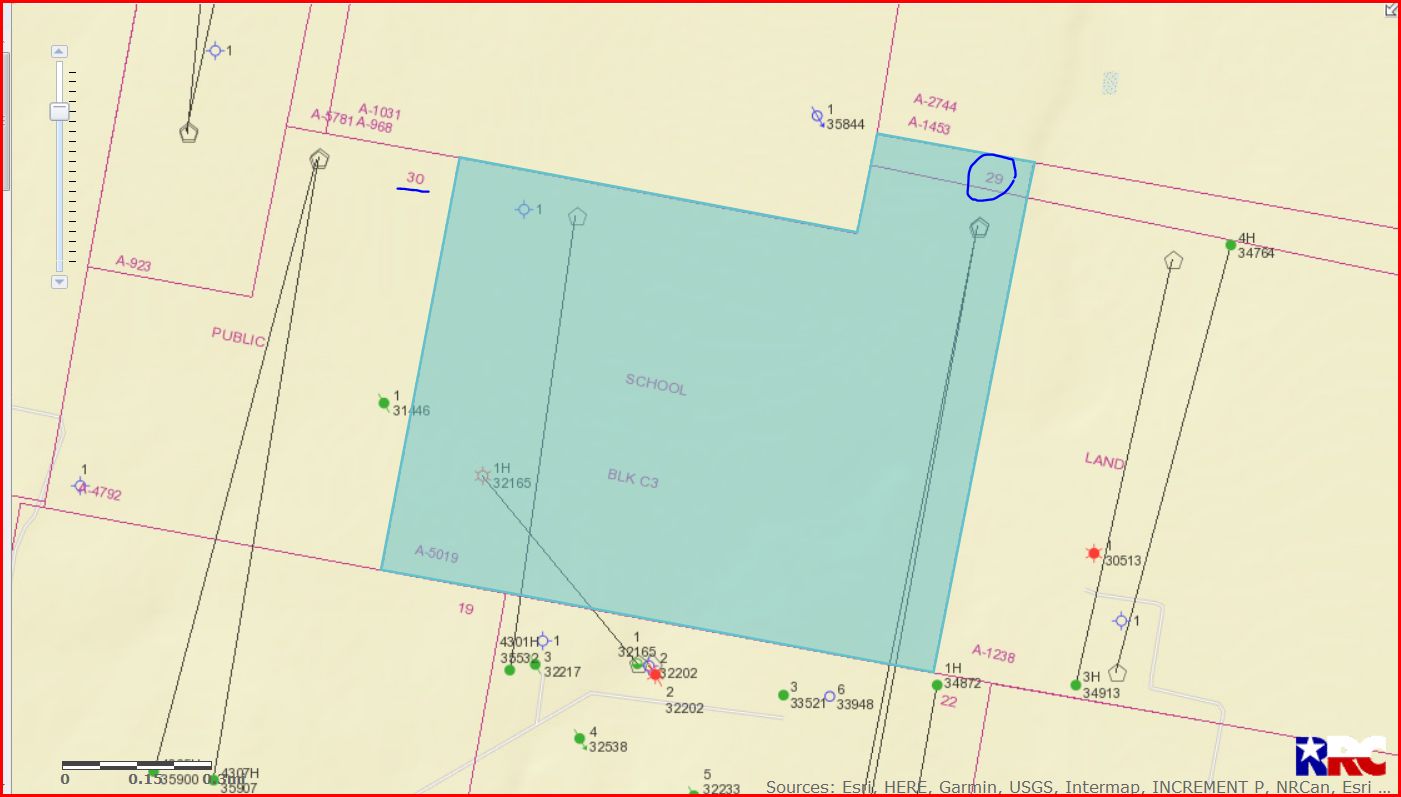
Thanks for the map.
Is the block to the right of Section 30 Section 7?
I don’t see a section number listed.
Thanks
Susan Titus
Susan, that would be Section 29.
DOUBLE LEFT CLICK ON MAP TO ENLARGE
Clint Liles
Thank you for your help, I have sent an email to PRI and see what their plans are. Thanks again.
Clint, you gave me a lot of valuable info. Thank you for your help.
I’m in a production pooling agreement with Section 7 and Section 30.
Would you let me know where Section 7 is located? I can’t find it on the map.
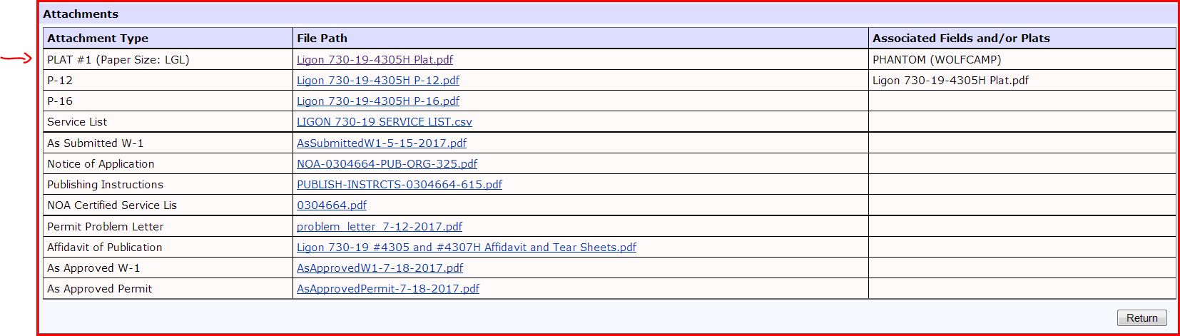
Susan, after checking the plat map I see where a Section 7 is mentioned and also an Abstract 4923. Abstract 4923 is in the 30 miles or so from Section 19. I also noticed on the P-12 where your name is mentioned and your 80 acres. If you haven’t checked, go to the very bottom of the approved drilling permit and you can click on the plat map and P-12 (pooling authority).
I think someone made a boo-boo on some of the paperwork. Give the oil company a call and see what they have to say.
DOUBLE LEFT CLICK ON DOCUMENT TO ENLARGE
Clint Liles
Thanks, Clint!
What’s the name of this document?
Susan Titus
Susan,
This is the plat map of the lease.
http://webapps.rrc.state.tx.us/dpimages/img/3500000-3599999//PR0003547671_0001.pdf
Link to approved drilling permit for well 389-35900:
http://webapps2.rrc.state.tx.us/EWA/drillingPermitDetailAction.do?methodToCall=searchByUniversalDocNo&universalDocNo=490958390
These attachments are at the bottom of every approved drilling permit. After clicking on the approved permit link scroll all the way to the bottom and click on plat #1/Ligon 730-19-4305H Plat.pdf to view plat map.
DOUBLE LEFT CLICK TO ENLARGE DOCUMENT
When you click on the P-12 it will show that you own 80 acres of minerals in this lease.
Clint Liles
Clint,
What does wolf camp and phantom mean?
Would you consider this in the Delaware Basin?
Thanks for all of your help.
Not Clint, but Phantom is the field name. Wolfcamp is the producing field formation. This is in the Delaware Basin.
Thank you.
I’ve been looking at some maps and thought it was in the Delaware Basin.