Linda,
I post drilling permits on a daily basis for Scurry County. Check out this link:
Linda,
I post drilling permits on a daily basis for Scurry County. Check out this link:
Thanks Clint!
I hope the link works. This was the first completed well I have seen from Trail Ridge who looked pretty committed to Scurry County. Can anyone shed light if this is good, fair, bad?
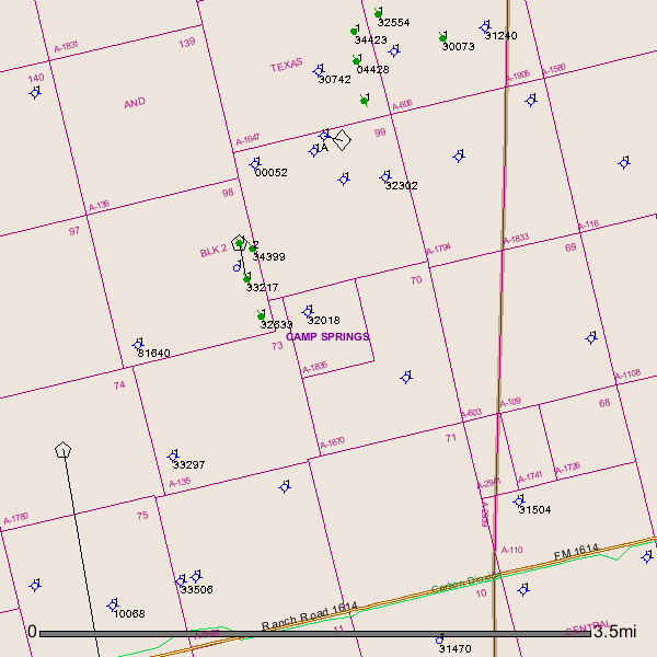
Any drilling around H&TC Block 2 Section 69 or 70?
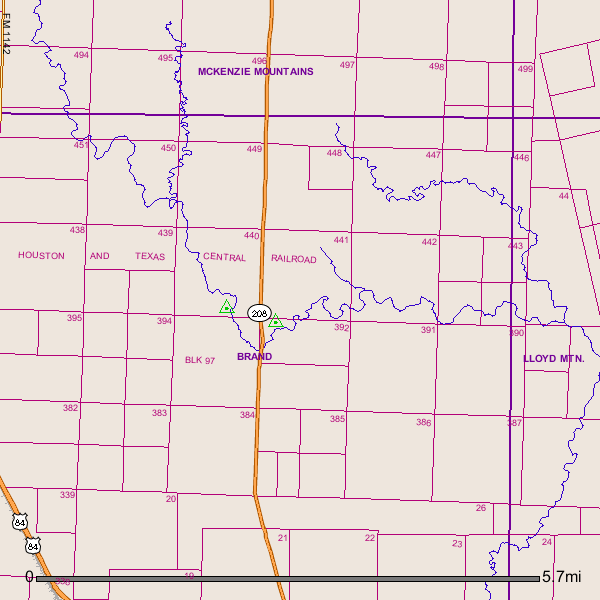
Can anyone tell me what quadrant of Scurry County that Block 97, H&TC Ry Co. survey is located? Thank you.
Mark, the eastern half of Scurry County contains Block 2 and 3, H&TC Ry. Co. Svy. I will check my map but another good resource is the GIS mapping feature at the General Land Office website and also the GIS mapping on the RRC website!
Mark,
Block 97 looks to be 5 to 7 miles due north of the City of Snyder.
GIS Map of Scurry County Texas Block 97 and surrounding area (oil and gas wells and pipelines have been removed from this map):
Clint Liles
Clint & Rebecca- thank you both. MB
Mark Baudoin,
Not much going on in the area of Block 2/Section 69-70 although a horizontal well (API 415-35050) was drilled in June 2014 to the S/W in Section 74/permitted for 6,000’/Wolfcamp formation/no completion report found. An older well (API 415-33217 in Section 98 was drilled in 1992/completed as oil well/Recompleted in 1996 as Horizontal oil well/Canyon Reef formation.
GIS Map of Scurry County Texas Block 2/Section 69-70 and surrounding area:
Numerous older plugged oil wells and dry holes in the area.
Clint Liles
Hello Clint, Mark & Rebecca,
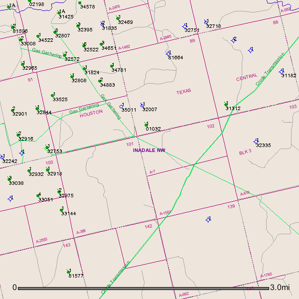
This is Vicki in San Francisco CA. My husband’s grandfather was Robert E Joyce of Scurry and Fisher counties, and we inherited mineral rights including 1/14th of 640 acres - Block 3 Section 103. We leased to Nehemiah Energy, one of the King Operating group, in July of 2011 and they have now allowed the lease to expire without any follow-on. We would be interested in re-leasing or even selling this mineral interest. What should we do? Thanks in advance for your help and advice.
Hello Vicki,
The last activity I see in the area of your Block 3/Section 103/A-613 was in April 2013. I see numerous plugged oil wells, dry holes and some producing vertical wells in the general area. Directly to the west of you about a mile well API 415-34883 (Vertical well) was drilled in Section 90 into the Strawn formation. Completion Report shows 37 BOPD (Barrel oil per day).
Also May 2012 another well (API 415-34781) (Vertical well) was drilled into the Ellenberger formation. 75 BOPD. Link to Completion Report on well API 415-34781:
GIS Map of Scurry County Texas Block 3/Section 103/A-613 and surrounding area:
If I were you I wouldn’t sell unless you are desperate for money. If you need to sell friend me and I would like to have a consultation with you in private.
Clint Liles
Allie,
After checking numerous approved permits for Scurry County I don’t see any operators/oil companies targeting the Cline Shale formation. The Clearfork, Mississippian, Ellenburger, Wolfcamp and Strawn seem to be the targeted formations.
Clint Liles
Clint,
The well in Section 74 has only been permitted. There are 4 Cline horizontal wells in the eastern half of Scurry County, Texas: Trail Ridge has drilled and completed the May 891H and the Hench Wild Wings 771H. Devon has drilled and completed the W Ranch 1H and La Roca Energy has drilled and completed the Emma 76 Unit 1H.
Thanks Rebecca for the update. I hope they are good producers.
Hello…I am looking to lease and/or buy 5-10 acres of land, preferably off a major highway or County road for the purpose of possibly obtaining a permit for a saltwater disposal well. Three (3) phase nearby would be a huge plus. Please text/call Tim Terry at 512-791-2499.
Does anyone know how these 4 previously mentioned wells have produced… Trail Ridge has drilled and completed the May 891H and the Hench Wild Wings 771H. Devon has drilled and completed the W Ranch 1H and La Roca Energy has drilled and completed the Emma 76 Unit 1H? Thanks for any info or updates!
Can anyone please provide various examples of typical money (bonuses and percentage royalties) being offered now (December through January and later, 2015) in Scurry near Hermleigh, Section 232, Block 3, H. & T. C. RY CO. SURVEY. I have been recently offered a bonus I believe inadequate. I have about 180 mineral acres. Thanks very much.
Does anyone know the results of the Macondo No. 2 and the Thunderbolt or whatever the name north of the Lone Wolf Cemetery? Please comment. They are taking the drilling rig down at the latter one and look to be completing No. 2 at the moment. Thanks.
My mistake. The wells I am interested in are by Three Span located in Midland, TX. Wells are located in northeast Mitchell County and southeast Scurry County across the county line, near Lone Wolf Cemetery. Another one northeast of Lone Wolf. I understand one is named Mapache 3.
What I observe from the road is oil being produced, wells being equipped with pump jacks, with trucks hauling away something!