Can anyone tell me if this has a well in this range and if the drilling in this area is coming to this zone? N/2NE/2NE/4SE/NE Thanks.
Moved your post over to Eddy County, NM.
Thank you, I appreciate it. I’m new to this.
Valerie,
Chevron drilled 3 Wolfcamp wells in the E/2 of Section 15 and 22. All spud in August 2019. See below.
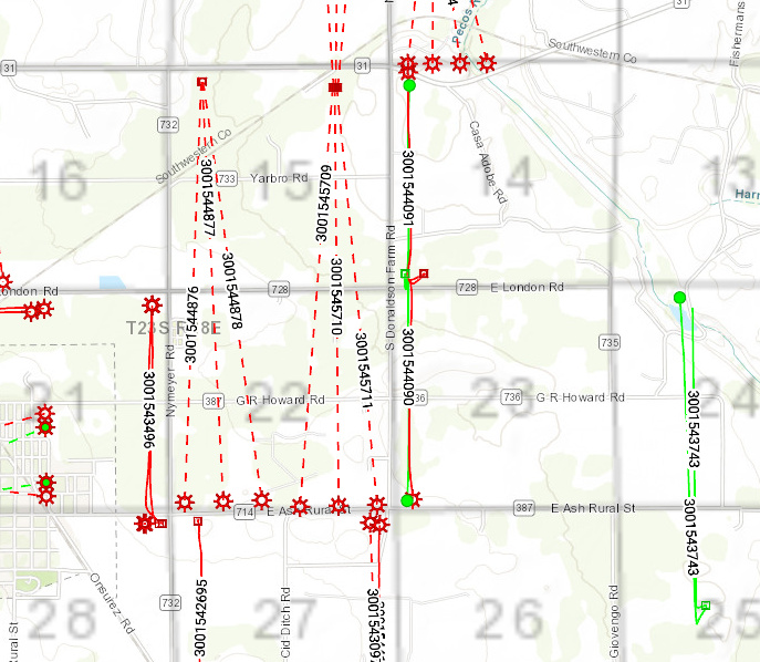
Assuming I am reading your legal description correctly, you own something in the N/2 of the NE/4 of the SE/4 of the NE/4 (5 acres)? And should have ownership in all 3 of those wells. You figure they would start producing 1Q2020.
The above map is just horizontal wells, there is also an old Marathon vertical well in the SE/4 of the NE/4 (API 3001526471) that has been producing since 1990. Witt #1.
Thank you so much. When I searched it I couldn’t tell which one because I didn’t understand the letters before the Section, Township, and Range. I don’t know what ours is. Hope you understand what I am saying lol. Hard for me to describe what I’m talking about. I have learned so much about this in about 2 weeks and I love this forum.
I don’t know for sure that the 3 wells are going to reach us. Looking at the map it looks like it misses us. We live between 31 and Yarbro on Donaldson. Now, I don’t know how it all works so could you explain it to me. Because those are correct N/2NE/4SE/NE4. Appreciate the help.
All of the mineral rights in the E/2 of Sections 15 and 22 (640 total acres) should be “pooled” (i.e., put into a common pot) for those wells. So the wells don’t have to go through your specific tract. In theory, they will be “draining” all of the E/2 of both of those sections, so ownership in those wells would be determined by the fraction of the total acres that you own. If you have, say, 5 mineral acres in that 640 acres, leased at say 20% royalty, you would receive this portion of the revenues in those 3 wells:
5/640 * .2 = .0015625. As an example. Make sense?
Note also that those well lines are straight lines from the surface point to the planned end point; the actual trajectory that was drilled will bend to cover more of the acreage. That info just isn’t public information yet as the wells were just drilled.
Have you leased these minerals?
No, we haven’t heard anything from them about leasing. I have 25% and then my dad had 25% next to me. I am his personal representative. I had put the wrong directions down so didn’t know if that was the problem. But I understand now what you were talking about. I appreciate your help.
I put the wrong directions. These are the right ones: N/2 NE/4 SE/4 NE/4. Thanks.
Also I have 2 acres 25% and my dad has 3. There are 5 heirs so each one will get 5 percent of his 25%. This is so confusing. But I’m learning. With all the research I’ve done this forum has been the most help!!
I know that isn’t many minerals or land but for us not know we even had them we are pretty excited lol
Well, if you are not leased you probably want to call Chevron and tell them you own in E/2 of Section 15. You don’t really want to get force pooled (included in the unit as an unleased party) but that may have already happened. Call Chevron land department for Delaware Basin. Ask if they show you as owning in those wells. If so, ask them to make you a lease offer. That is what I would do.
Those wells are the CB NE 15 22 wells.
I got in touch with them and they said it might take 30 to 45 days. I knew something was up when I got that call from the Landman. Just wish it would have been Chevron’s Landman. Thanks for the help and I will let you know what I find out.
This area has been “force pooled” by Chevron. You can go to NMOCD website and look up Case #20332.
List of parties pooled is on page 7 and 8 of this document. Maybe see if one of them is you.
If your family has held these minerals since before the 1980s, then your father should have been receiving royalties from the Yarbro Gas Well from the 1980s on through 1999. Then from the WITT oil well from 1990 on to the present.
You really should be communicating with Marathon also since they are the operator of the WITT well. They should have been paying you since 2017 and before that was Black Mountain Operating.
Good luck tracking it all down.
1 Like
Thank you, that information is awesome. Our name wasn’t on there unfortunately and Chevron is giving me a runaround. But I won’t stop.
I’ve got a call into them but so far haven’t heard anything back. This forum is wonderful and I appreciate everyone’s help. Thanks.
Our name was not on it. So what does that mean? Do we have so little % minerals they don’t have to contact us?
Chevron told me they weren’t sure if we had any interest in those wells because they don’t have an API number and they weren’t showing up. That they haven’t been drilled yet so they couldn’t tell without the API number. I think they are giving me the run around.
We’re having trouble with Chevron in this section also. We inherited leasehold working interest in Section 15, Township 23S, Range 28E, Eddy County. We received AFEs for the East half, but none for the West half. The interest in the West half is small, but their ‘agent’ said that we didn’t have working interest. That seems completely illogical because we still have, and are being billed, for an active well in the West half. The JOA for that well is for the 320 acres of the West half and includes the Wolfcamp zone (which is the zone to be drilled). We were provided with AFEs for the 2 Heritage wells in the West half (in 2012 I think) and chose to not participate. Nonparticipation does not sever mineral rights. I have not been able to get a reason for what happened to our working interest rights after requesting the reason via email and certified letter. Any suggestions would be appreciated!
1 Like