I own property in Reeves County, Lot 24, Section 8, Block C, 18 and have received offers to purchase the property. What would be a fair price per acre in this area?
If those were my minerals and I owned 100% in each acre I would take no less than $20,000 per acre. JUST MY OPINION.
1 Like
As Clint said, just my opinion as well.
Make sure you know what you are being offered and what you own. If that sounds condescending, I apologize, but you’d be surprised how often this seems to be the case. People offering you money or advice or whatever may not always be talking apples to apples. You will have people offer you per net revenue acre, or mineral acre, or royalty acre. That’s an 8-fold range for the exact same total amount of money. There is nothing worse than trying to explain to someone that was offered $60,000 per net revenue acre that their offer is actually less than a $10,000 per net royalty acre offer.
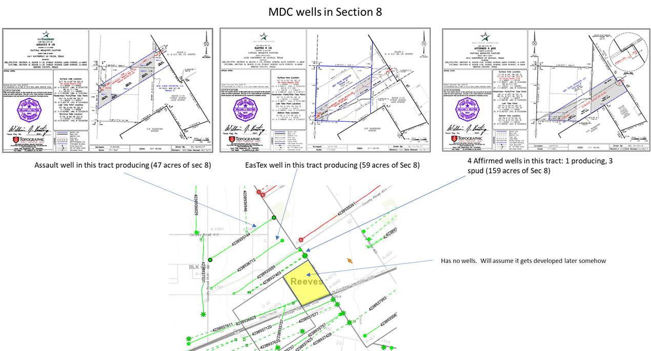
Not all of Section 8 is the same. MDC has broken up the North part into 3 different units. See below. If, for instance, your acreage is in the Affirmed unit, you have 4 wells that have been drilled in it. That is pretty good. The other two have a single well thus far. Less good. The southern yellow part has no wells and its development may happen much later, there is some chance it gets stranded somewhat.
I would not sell the Affirmed acreage for less than $32k per net mineral acre. If in Assault or Eastex, I’d say $26k per net mineral acre. If in the yellow part, then maybe $22k per net mineral acre. That’s my opinion based off a whopping 20 mins over lunch. Good luck.
Where is Sec 8, Blk C18, in regard to my land? Could you send a larger picture of the area around my land? Just wondering of the activity around me. Rather the just my Sec 8. Thanks. Louise
Thank you for doing that during lunch. Where could I find those maps? I am having a hard time with the links. Thank you!!!
Where can you find those maps? Assuming you can see that image, the 3 permit plats at the top are from RRC website.
It’s not very intuitive, you have to enter the API number for the well in the upper right box, then search the permit until you find the plat. The API # is the 10 digit code on the lower map (e.g. 4238936712, where 42 = Texas, 389 = Reeves County, last 5 digits are for specific well). As this is Texas RRC site, you leave out the 42 when you search by API number, so would just be 38936712. See, simple right? ![]() Here is a link to one of them that is a pdf, can’t link to tifs.
Here is a link to one of them that is a pdf, can’t link to tifs.
The lower map in the picture I included was from a subscription service.
If you want to see a map of something, maybe just PM me and I can email it to you. I don’t mind for minor requests. Cheers.
1 Like
I just read my deed and it says I own all rights title and interests in this parcel. Do I own mineral rights and everything???
Joeg -
Not especially. Depends upon prior record title: What did the people you purchased your land from own to sell you?
Hey, Louise!
If you will download the following, you will see that Section 8, Block C18, PSL, is 15 to 20 miles to the South, Southeast of your lands.
You will also see that quite a number of wells are currently being drilled in your area and that a bunch of the ones that have already been completed are very productive.
Good for you!
Hope this helps -
Charles
LOUISE WELCH LANDS TO SEC 8, BLK C18 - LOCATOR MAP.pdf (88.0 KB)
LOUISE WELCH LANDS, REEVES COUNTY, TEXAS AS OF 2019 01 10.pdf (408.6 KB)
1 Like
Thank you so much for the info. According to Energen, they have completed the drilling and production. Can you give me an update? Would appreciate it.
You’re welcome! They apparently have not submitted any Completion Reports or reported any Production figures to the State yet on your Skyfall Wells. Remind me in another couple of weeks and I’ll look again.
1 Like
Thank you for your help. Where did you go to get the information? How about private email and telephone number?
What is going on in Section 39, Block 72 PSL and Section 42, Blu 72 PSL?
Any updates on the Skyfall wells as for production reported? Just curious as to why they holed up. Waiting for higher prices per barrel? Thanks for any info.
Brenda, it doesn’t appear that there is any new activity on either of those parcels. Chesapeake had a permit filed in 2009, but they expire after 2 years.
Louise, what is the legal description associated with those wells?
1 Like
Blk 55 Sec 8 T4 A2098 Reeves County Thanks for any info.
This is wonderful information and great instructions on how to find!! Do you know if there is any place to find Joint Operating Agreements since they don’t have to be recorded? Thanks!
1 Like
Louise, the 605H well had some problems with the permit that were just recently resolved in November. So, perhaps they now have the well on the drilling schedule? Who knows, but I don’t see anything to show the well(s) were spud yet.
1 Like
How would I find out if I am pooled with other landowners in Section 8, Block 55, Township 4, A2098?