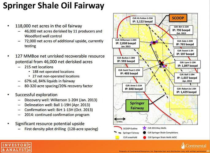
Hey Grady County Mineral Owners, since it is difficult to find the old data related to this topic; I was curious if we could post anything to do with CLR’s “Project Springboard” to this thread? I know Don and some others had some really good maps/graphics that illustrated the sections included. I don’t think anybody can find those old charts in this new designed forum.
Joe,
The board search (magnifying glass at the top) is pretty good about finding topics containing discussion.
By searching on the word springboard, it brings up the archived thread imported from the old comment wall at the point where it came up.
Here is a link: https://www.mineralrightsforum.com/t/grady-county-ok-oil-gas-discussion-archives/1412/22311
You can also go to that same thread and scroll through it just as you would have on the comment wall on the old board.
Thanks, Rick. But at my age it is difficult to let go of a system that I know and like in order to take up another. Sigh. But also, at my age, I have learned to accept fate and adapt. Jim
Jim,
The old board software was outdated and no longer supported. It had security vulnerabilities and I just imagine compliance issues.
This software would not have been my choice to migrate to, But I’m also not the one paying the bills and making those decisions, so I just make the best of what is here.
There are things I like better about this software, and once the get done if the bugs worked out it should be better than the old software. For the record, the old format was so frustrating for me that I stopped using the forum from time to time.
Rick
Howdy Don, Well, I throw a comment on the wall and see where it lands…
Specifically, your Springboard spreadsheet was many days ago in another thread. Interested how the right border works.
What day did you post the spreadsheet?
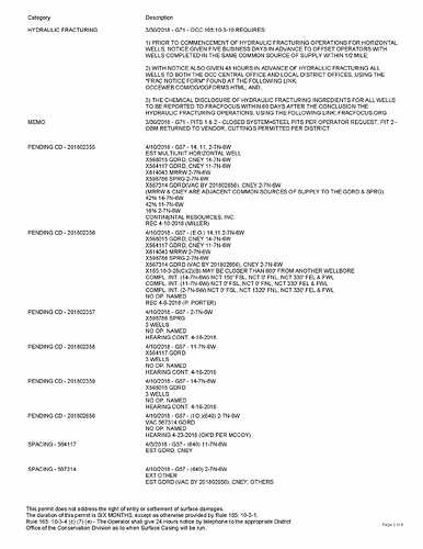
Recently received a Commission Order [signed April 18, 2018] granting Echo Operating LLC a 640 acre horizontal drilling and spacing unit in Section 20 5N 6W. Anyone know if they have started or about to start drilling at this location? Also, my current lease expires June 23rd. If the lease has expired and they have not spudded, will my interest be pooled? How does that work?
Howdy rdub, I originally posted the spreadsheet about 20 days ago. Around May 9 or so.
Sylvester, Went and investigated some stakes for well sights today. In section 20-07N-06W 3 stakes for Schoof wells drilling through sec, 17,8,5. In sec 21 2 stakes for Angus trust wells drilling into16,9,4. In sec 23 two rigs drilling Lowers wells into sec13,12,1. Also saw a rig drilling in sec 18 or 19 not sure which. Looks like the Springboard is in progress. .
Thanks, Rick.
And it looks like they have 9 wells planned for 14-11-2 - 07n-06w.
It looks like they are starting the wells in 23 but all the production will come from 14-11 and 2.
Maybe Section 23 will get the next group.
And it looks like all of those sections, 14-11-2, 17-8-5, 16-9-4, 13-12-1 are all in Row 1 of Don’s Springboard chart.
Continental said they were going to do Row 1 first and then the others.
And that’s what they are doing.
I guess the rest of us will just have to wait our turn!
Any thoughts as to how they are going to handle Sec 20-7N-6W in the Spring board? Section 29 to the south already has 5 Springer wells part of the Hartley Density Unit. Maybe they will just drill one Section wells in this section.
20-7-6 hit the Wilkerson in 2013 for 2038 boepd but no action since.
But you are right in the heart of the Springer Shale Oil Fairway.
And you are in Row 2 of Don’s Springboard chart.
So it looks like it’s just a matter of time for you to get some multiple wells too.
At least I hope so.
Anyone know what happened to the TRP Midcon application for 640 acre spacing in 26-8-6? I have mineral rights now being exercised by the Ellis well (Devon) and wonder if that well will be compromised. And if I will benefit from any wells TRP might complete and produce.
Scoop profitable at $34.60 per barrel. Better than Stack at $42.74.
_ concurring Rystad Energy NASWellCube analysis shows SCOOP wells completed in the first three months of 2018 averaging wellhead break-even prices of $34.60/bbl, compared to $42.74/bbl for geologically complex STACK wells.
http://www.worldoil.com/magazine/2018/may-2018/features/shaletech-scoopstack
That’s good because it looks like the price may go down for a while.
U.S. Asks OPEC for 1 Million Barrel a Day Oil Output Hike
That’s good because it looks like the price may go down for a while.
Or maybe not, with Venezuela production dropping so much.
The amount the company will not be able to supply is close to half of the total committed volumes of this grade, Merey 16, for June. It only has 578,000 bpd of the grade available, while the total contracted volume is 1.271 million barrels daily. PDVSA’s total crude commitments for the month stand at 1.495 million bpd, but it only has 694,000 bpd available.
More good news for Scoop i.e. Fantastic Returns!
_•The SCOOP and STACK wells of Oklahoma offer as good and sometimes better returns. _
The Permian problems continue to make headlines. But at least one major producer Continental Resources (CLR) has found a permanent solution to Permian bottlenecks. Management just will not go to the Permian because this company has fantastic returns elsewhere with far cheaper acreage.
https://seekingalpha.com/article/4179383-continental-resources-can-soar-without-bottlenecks
In Chickasha last night for a Softball Tournament. Counted five rigs drilling in the Springboard area of continentals presentation.
Rick, Thanks for the update. Nothing better than boots on the ground!
I see on OCC’s website that the multiunit wells named Lowers 3, 4, and 5 have all spud. They are drilling from 23-7N-6W into sections 4, 11 and 2. I have a small interest in section 3 and that looks like what may be next in line as the permits have been pulled for the multiunit wells named Robinson 3 and 4. They are drilling from 22-7N-6W into sections 12,10, and 3.
http://imaging.occeweb.com/OG/Well%20Records/1DD76335.pdf http://imaging.occeweb.com/OG/Well%20Records/1DD78055.pdf
This forum feels like a “ghost town” since the change to the new format. Sure miss M. Barnes!
Still looking for any information on drilling operation in 20 5N 6W. Looking for spud date if anyone has this information, I would be appreciative of an update.

