I am a complete novice to this world of oil and gas royalties. This is inherited property that I am trying to get a sense of activity and permits in the area and hence the possible valuation of the royalties if we wanted to sell. There is a total of 1760 gross acres in this area. If anyone has insight into the activity or possible value of this interest I would appreciate your input. Thanks.
1 Like
That is a good area! Not sure what you own so it is hard to give you an evaluation. I own some interest in 22-32 and recently purchased more.
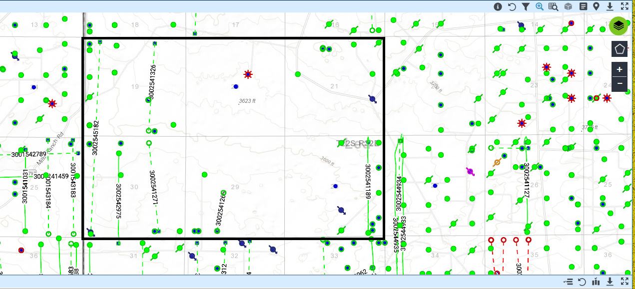
Looks to be 10-15 producing wells across the sections. Also two new permits (Section 30 - Oxy 9/18 approved & Section 29 - EOG 1/19 approved). You will need to research where your MI is to know if you are part of any of the current/potential wells but there is a lot of activity in the area.
We sold less than half of 1% ORRI in 19 S 32 East four sections 2300 acres for 1 million. Sounds like your area might command more but you have to work it. Took me about a year to get top dollar at the time. Sold in January 2019.
Thank you for the feedback. Can you direct me where to find maps of the area that identify sections, etc., and how to determine producing wells on these maps? I apologize but I’m not familiar with MI (mineral interest possibly)?
You’ll need more detail on your ownership—specific description of locations and interest percentage. If you don’t have that already, you may need to visit the county clerk’s office to pull title and mineral deeds for what you own.
Once you have this you can research specific well and permit info on the NM OCD site. The site has info on locations, depths, operator, production, etc. You can search by location, operator, specific lease numbers, etc.
Here are links to the two permits in Section 30 and 29:
Sec 30 Oxy Permit: https://wwwapps.emnrd.state.nm.us/ocd/ocdpermitting/Data/WellDetails.aspx?api=30-025-45182
Sec 29 EOG Permit: https://wwwapps.emnrd.state.nm.us/ocd/ocdpermitting/Data/WellDetails.aspx?api=30-025-41260
Good luck!
Oh and… MI = mineral interest… ![]()
Lea County has two title companies, one is across the street from the Lea County courthouse in Lovington, which is the county seat. The other title company (same company that is in Lovington) is in Hobbs.
You go to the title company and go through their title books for your location.
It can be frustrating because a LOT of the landmen that are ALSO doing research can tie up the book you want to use. But even a landman goes to lunch and can’t take the book with them and that is your chance to look up your property.
My wife and I have spent the past two years doing research on our mineral rights in Lea County. We have a tendency to look up what we need in the title company’s title books and that gives you a book and page that you take the two book and page numbers over to the county courthouse, go into the records department and ask them NICELY to show you where the books are (they are on one side of the room). First time around, it seems fairly daunting, but after that first time, it gets easier and easier.
Then you start your search. You will want to know how your family came to own the land, do you still own the land or was it sold. If it was sold, did they also sell the mineral rights? If they did not, your warranty deed will say “Surface Only” which means exactly what it says, your family still holds the mineral rights because they only sold the land, not the minerals under the land.
That is but the very first step.
My wife and I have done these particular steps numerous times over the past two years. We have learned more about my family and how we came to own the mineral rights we own.
Thanks for the information and resources.
Thank you for this detailed outline of how to go about getting the necessary information. Looks like I will be making a trip to Lovington in the near future.
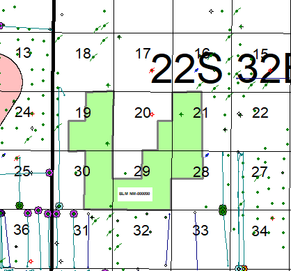
Looks like you are in a good area! Here is a map with your sections highlighted.

For well info you should look on ArcGIS Web Application (the New Mexico state well map).
The downside to the New Mexico oil and gas map is it doesn’t show the horizontals in the map, you have to look at the completion report. For your reference I went ahead and included a screenshot from DI that shows the horizontals.
Good luck!
Thank you for this valuable info and resources. I appreciate all help I can get.
Drillinginfo (DI) maps have some goofy data. Well 3002542975 is in Section 31, not Section 30. 3002541271 is a cancelled permit. Here is BLM lease NM-00090 which covers that 1760 acres. Has no horizontal producers and no active horizontal permits. As far as I can tell just held by single EOG well. Amazing Baz Fed #3. API 3002538450.
If you want an estimate of what it’s worth you pretty much just need to figure out what % ORRI in that federal lease you have. Which should not be too tough. BasinLandRecords will allow you to search Lea County records for a minimal price. Once you figure it out it’s fairly easy.
Oh, and circling back to the lack of permits/etc…this is a pretty good area, it will get wells eventually. The fact that none are permitted now means that if you are getting offers they are going to be lower than other places but it’s a pretty good area. A 1% ORRI on 1760 acres would give you 141 NRA, which should be worth about $2.25M IMO. Scale proportionately to whatever your ORRI is. That is my semi-professional opinion.
Cheers
Thank you so much for your comments, insights, and willingness to share your thoughts. I am not familiar with much of the acronyms so I have a pretty steep learning curve.
Sorry, some acronyms:
EOG = formerly Enron Oil and Gas. Oil company. Bought Yates Petroleum who had this lease. ORRI = overriding royalty interest. Cost-free share of revenue on a tract. NRA = net royalty acre. Equal to owning a royalty (or ORRI) of 12.5% in an acre. It’s just a way to measure the % of the revenue one is getting. If you get twice as much revenue, your land is worth twice as much. 1760 * 1% / 12.5% = 140.8 API = the unique number assigned to a well. So 3002538450 = a specific well in Lea County. BLM = the Feds
I did briefly check BasinLandRecords and actually found nothing in Lea County. I would guess that anything associated with your ownership was filed with the BLM which is, as far as I know, impossible to research online.
Have you gotten offers on this property? It sounds a little bit backwards, but I think most folks offering you will be able to tell you what you own as they will have done some title work.
Wow, thanks for the information and clarification on these acronyms. Yes, my aunt was contacted by a landman regarding this property late last year. This person provided her with the property description and the ownership details. In my mind it begs the question: What other property or parcels of land are out there that the family has no idea they (we) have ORRI on? It looks like I may be going to Lovington in the near future to do some research.
Thanks again for your help. Several people have commented on this forum about your knowledge and insight into the world of oil & gas royalties!
You can search the original patents at the BLM and then work forward. Search - BLM GLO Records
Thanks for the information and direction!
I don’t think you have to rush out to Lovington to make sure that you don’t have any long lost minerals. (Which frankly, if you are starting from a blank slate is a rabbit hole you may not climb out of for years). IF you & yours are the rightful owner of mineral interests in the better parts of the Delaware basin… people will find you and offer you $ for your minerals. Similar to this BLM lease. That is the upside of frenzied activity, you don’t actually have to go and find out what you own. Of course, the downside of frenzied activity is exactly the same, people will find you and offer you $ for your minerals. ![]() Blessing and curse.
Blessing and curse.
NMoilboy,
I disagree. And the reason is ONLY YOU know the names of ALL your relatives.
A Landman won’t. The Title company people won’t. The wife went out to Lovington by herself one time (I was pretty sick at the time) and with HER looking at the Title company title books, she discovered an additional 200 acres by searching the title book for a Section, Township and Range that was not actually on our radar, but she had seen an OGL written to a name she recognized and followed that and then discovered the 200 acres and we followed that back to the beginning of the parcel and found the Patent in the name of a different relative and then how it ended up in my grandfather’s name.
NO Landman or title company employee would have ever known that. And that is WHY you should do your own research BECAUSE ONLY YOU KNOW YOUR FAMILY AND ALL YOUR RELATIVES.
Trust me, we would have never known about that 200 acres if the wife and I didn’t do our own research.
We thought we only had a certain percent of 320 acres. Now, we KNOW we own the 200 acres and part of the 320 acres because we were our own researchers.
THAT is why you should go out to Lovington yourself. NO ONE, and I mean NO ONE will know your family like YOU. Your family might gain enough info to make it worth your time.
We even found that the family did a Quiet Title back in 1948. That resolved several issues from the 1930’s…
Only you can be the best researcher for your family.
Having had to run down “lost or unknown” minerals in Lea and Chaves Counties, I think both of you are maybe right! I found some by a landman with some real tenacity tracking it down to offer a lease. These were so old (26 years since the owner died) and hidden I am not really sure how he found them (us) at all! That said, if nobody is actively looking to lease the minerals, we well may die before our ownership is even known. I have spent many hours trying to track more down, with only slight success.