Geo Southe
More info popped up on the austinchalk website I posted earlier with WRD well results and more info on permitted/drilled wells: https://austinchalkoilgas.com/august-2017-activity-update/
And here I was thinking that website was a One Hit Wonder. There’s a lot of technical jargon in there that’s way beyond me, but I know enough to understand that the author is excited about what’s happening.
And he makes a good point about GeoSouthern secrecy. I sure haven’t been able to find any GeoSouthern website at all. Sooner or later they’ll have to begin reporting something more to the RRC and then hopefully we’ll all be grinning.
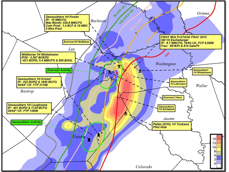
I’ve been pondering more of this https://austinchalkoilgas.com/august-2017-activity-update/ and was interested in the inset map in the bottom left of his Figure 2. With apologies to the author because I suck at computer graphics, I took that portion and blew it up to the point where it started getting fuzzy. See attached.
I just wanted to get a good look at how his SoPhi-H map (whatever SoPhi-H is) compares our area to down the country in Karnes and DeWitt counties. Going strictly by this map, I don’t think there are any flies on our area at all. I hope SoPhi-H is right.
2866-AustinChalkchart081617.jpg (111 KB)
Interesting map showing operator acreage
Bart
Thanks for keeping us up on all this data.
Do you know anything about who authors that site?
Go back to page 381 (May 16) and you’ll see the link posted by Kirk Barrell. Here’s Kirk’s LinkedIn page: https://www.linkedin.com/in/kirk-barrell-6a97525/
Here’s Amelia Resources: http://ameliaresources.com/management/
There’s nothing to say that Kirk is the actual author of that site but regardless I’m glad Kirk posts from time to time and am sure glad that I know about that website. Even though I haven’t bought any Escalades yet, I’m fairly enthused.
Keep in mind the footnote on the acreage map from your link is omitted. Go to the actual Wildhorse presentation here: http://www.wildhorserd.com/wp-content/uploads/2017/08/WRD-Company-Presentation-Q2-2017-Earnings-vFINAL.pdf and go to 6/36. Then you’ll see that they got their figures from Investor Presentations, meaning that unless a company is publicly traded that they won’t be on the list.
For instance, GeoSouthern is not on there anywhere. And not that they operate in our area, but Lewis Energy admits to 450,000 acres. So that list is not all inclusive… not that it matters because it’s very interesting nonetheless.
WI
You and I are talking about two different reports from different sites. The one I was asking about was first posed by Bart Moxa on that same page 381 but his post was dated May 22 and he gave this link https://austinchalkoilgas.com/. I don’t think that report or the update from that same site that Bart posted yesterday are connected with the report by Kirk that you were talking about above. Am I wrong?
I think here’s what happened:
We were discussing this site https://austinchalkoilgas.com/ that we believe is authored by Kirk. So then when you click on Activity Update August 2017 you get some information on Wildhorse that includes the link to here http://www.wildhorserd.com/wp-content/uploads/2017/08/WRD-Company-Presentation-Q2-2017-Earnings-vFINAL.pdf which is a real jump on my part and I’m sorry for the confusion. I’m confused, at least.
About 10 belly dumps turned down 966 this morning. Any ideas?
I don’t think that you meant 966 did you? Did you mean 956 instead? If so, my guess is that they’re building the pad for the BEUSA Kveton Bros. well. If they turned north onto Falke-Heinrich Rd the surface location of that well is between F-H and 77.
2865-KvetonWell081817.pdf (483 KB)
Hell idk the fm to Freyburg.
That’d be it, then. I imagine that’s what’s happening unless it’s not.
Dusty:
I don’t know much about the site’s author. I found it linked on oilpro.com (which is now defunct) about a month or so ago. I bookmarked it and checked every so often to see if he updated, and it didn’t look like he was, and then the boom—a full-blown update. I think he updated after Wildhorse published that big chalk result.
Thanks Bart. I felt like you were the source of that link and it didn’t relate to Kirk’s site.
I definitely like all the detail in https://austinchalkoilgas.com/ but when the guy refers to himself as a promoter and apparently wants to stay behind a curtain it makes you wonder.
Gentlemen,
I do NOT author the site www.austinchalkoilgas.com. I DO author:
Historically, I’ve focused mostly on the Louisiana activity. I will be posting updates on Giddings and the Karnes Trough. It’s exciting to see EOG pursuing this play. They’re the best unconventional operator in the biz. I’ll have a new post out today.
Thanks for clearing that up. Looking forward to your new post. We’re all starved for some news.
Does anybody know where is the location oil and gas permit submitted by Geo Southern, Herbrich 1H API-42-149-33429?
Here’s how you find that information…
First go here: W1 Search
Then fill in your favorite county in the drop-down box in the upper right.
Scroll down to Lease Name on the left side and enter ‘Herbrich’.
Then click Submit in the far bottom left.
Some information on that search will pop up and you can pick the well you want if there are multiple hits by clicking on Lease Name.
That will bring up even more information including the actual plat, but for the location you’ll see toward the top Surface Location Information and directly after the API is a small colorful Texas icon. Click that and it will bring up another window showing the well location including lateral (if any).
Having said all that, Herbrich straddles FM 155 and the surface location is just off of Anton Salas Loop.