If it is 160 miles one-way, then 320 miles roundtrip and maybe as much in transport costs as for the sand itself since there isn’t going to be a practical backhaul from the frac site back to the immediate area around the sand mine.
In end-of-the-week thinking about things that would help our Schadenfreude, now “20 cents-per-share” Sanchez, maybe they just need more perseverance.
I see that Texaco, a company that survived almost 100 years but was acquired by Chevron in 2001, would now control in their former West Texas properties the most productive shale fields in the world, if only they had survived another 15 years or so. https://www.ttnews.com/articles/texas-shale-forces-big-oil-cost-revolution-chevron-ceo-says

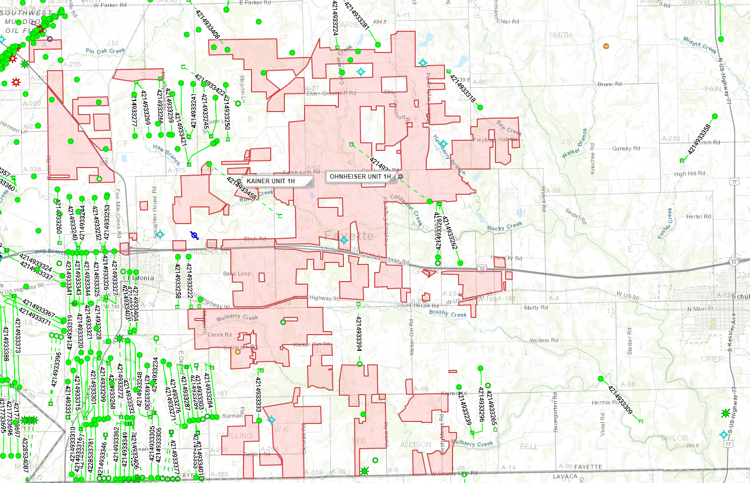
Link to completion on Tri-C Ohnheiser. Three miles east of Kainer. Only about 1/3rd the liquid volume of Kainer although lateral was 1000’ longer.
What does that mean Dusty1…?
It will be interesting to see where or if Tri-C drills a third well in the area.
Agree, but seems like a 300 bpd well should still give a decent payout.
Can somebody say how big Tri-C’s lease block is and where these two wells fit into it? Are they defining the boundaries?
I would be really surprised if 300 BOPD (24hr test) was considered a successful well. Considering a well cost of say 8 million, even with no decline (wells in the area have about 85% first year decline), it would take a year and a half to pay out… IMHO doubtful they would want to drill more of these.
Did y’all notice the TVD (total vertical depth) of 11,533’? Good grief! Are they trying to get Chinese oil from the back side? I thought the average TVD for an EF well is about 7,000 feet. In addition, the MD (measured depth) is 21,147’. So this makes the lateral almost two miles long. No telling how many frac stages there were in two miles.
So personally I would be hugely disappointed in a 300 BOPD output on such a grandiose project. Of course, that’s provided that the office help was correct in reporting to the RRC and depending on expertise and/or luck how many frac stages were actually successful.
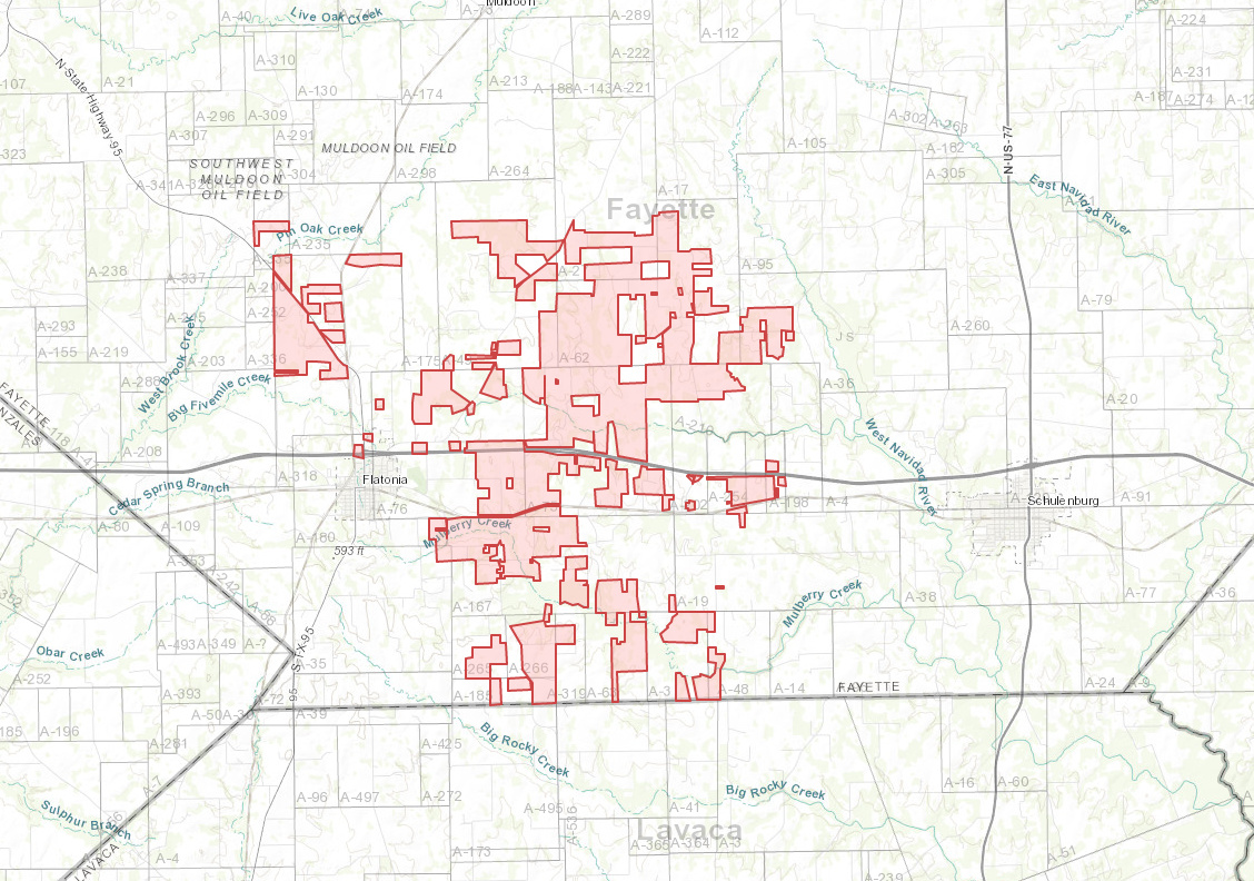
Regarding their leasing, I browsed through their leases on texasfile.com and checked the Surveys. It appears to me that the best way to describe it is “everything not previously leased” maybe from up around Freyburg down to about Praha and a little to either side of that line. Most of the leases are in Fayette County but a few are in Lavaca.
We’ve discussed the price of oil needed by certain countries in order to keep the lights on. Well here’s another article on that subject: https://www.reuters.com/article/us-saudi-oil-prices-analysis/more-shale-who-cares-saudi-arabia-pushes-for-at-least-70-oil-idUSKCN1R31IP
It would seem that this plays right into our hands provided that they can actually get the price up there.
The well is still cleaning up, so I wouldn’t look at the 300 IP as peak rate by any means. I was told it may be another 60 days for them to recover all the water from the completion and get better flowback results. It will be interesting to see how the well ends up.
As for Tri-C’s position, see attached:
Thanks William1 - that sounds promising!
Here’s a guess on where the Kainer (blue) and Ohnheiser (green) are on William’s map of Tri-C’s lease area.
I hadn’t realized the Ohnheiser unit joins the north side of the Kainer.
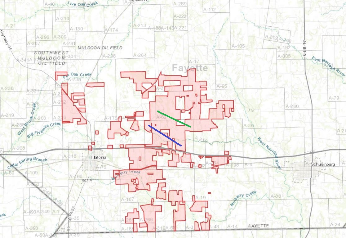
I suspect this lease map is well out of date. The blue line is the approximate Kainer well to the best of my knowledge.
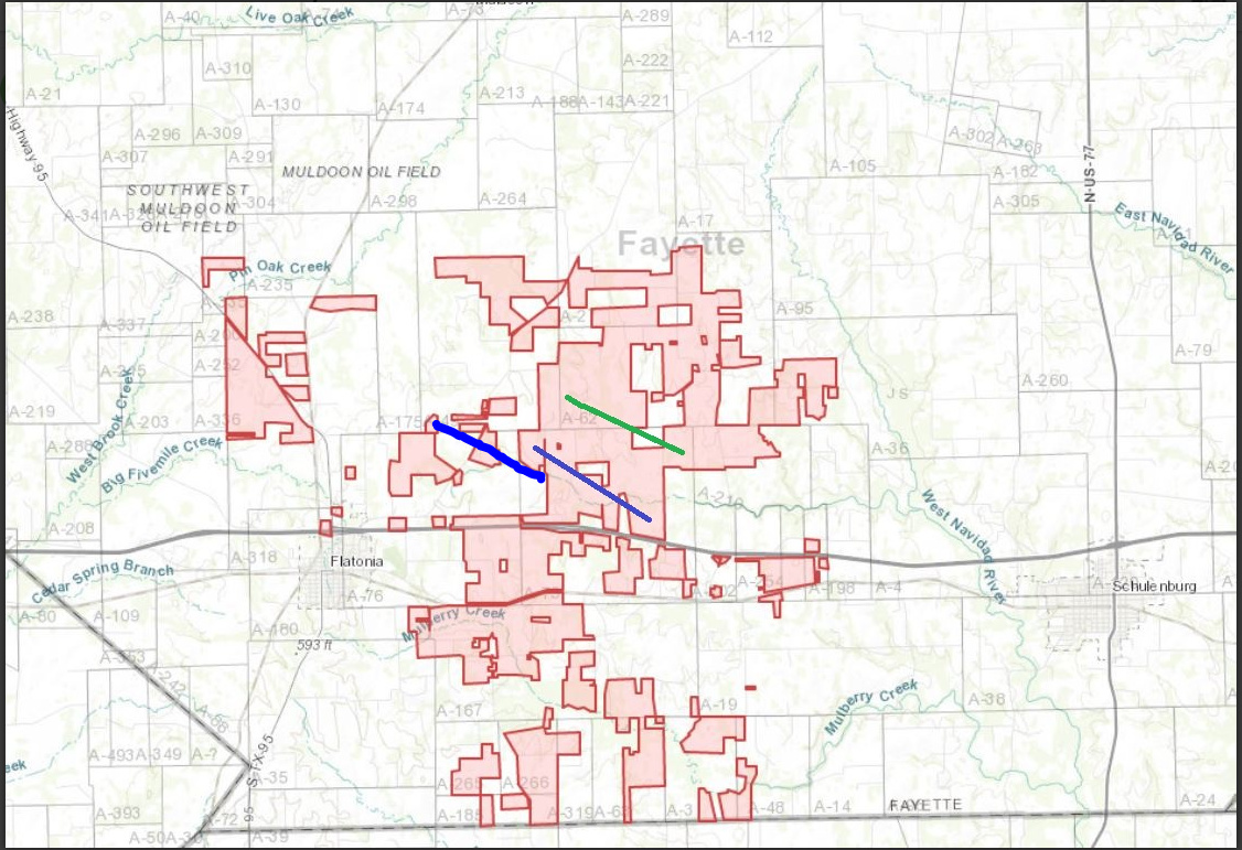
It is a generated map based off RRC filings, so it may not be entirely accurate but it’s going to be pretty close. As for the gaps, that’s easily explained that they could have a JOA with whatever company owns those “blank” spots, and Tri-C is designated operator. Here’s the same map with the two wells we’ve been discussing.
This is a really great map William1. If we get on a real computer (not a phone) and enlarge it you can really see something!
I realize that this is closely held information but since we’re all about rumor and innuendo around here I’m curious as to the number of barrels of water they pumped into a two-mile lateral and the percentage of frac water still to be retrieved now nearly a month after the flowback test on 02/22. And as a related question, where’s the nearest disposal well? Trucks running 24/7 for two months has to run up some amount of cost. Plus now it’s a little over two months after ‘1ST PROD 1/19/19’ per the RRC report I wonder how it’s currently doing. All rhetorical questions, of course.
Hi y’all. New to Fayette County group. I picked a little bit of acreage in Fayette County a year or so back and the lease is expiring soon. Wondering what lease bonuses are like in the area. Couple acres in Faires Survey (A-180) SE of Flatonia and few acres in Toy Survey (A-150) in the NE part of the map of Tri-C lease area from previous posts. No idea what’s on the surface there / where they are in real life.
Also, Drilling Info is showing the Kainer 1H well’s January production as 23,726 bbls & 8,481 mcf. Hopefully this is helpful.
William, curious what you mean about that being a “generated map based off RRC filings.” Did you generate it or is there a place you can find that kind of information on other areas or operators? What kind of RRC filings would that be, not permits or unit plats, right?
Dusty, I am using DrillingInfo and some of their companies/subsidiaries. Typically, unless companies have investor presentations that show their acreage positions (which DrillingInfo then digitizes), DI will look at RRC filings and lease plats, etc. to try to generate the company’s position. So it isn’t 100% accurate but at least gives a solid idea of where their presence is. Also, they will look at leases on file in the county and digitize acreage positions based on that information as well.
But yes, they would look at lease plats, unit filings, etc. by the operator to help them generate the maps.
Again, great map William. I guess what it really brings home is just how much activity there is immediately north and south of Flatonia, and how little there is to the east.
Looking at the wells closer to our area from West to East along the same line of latitude it looks like they are watering out as they go easterly and deeper:
Kainer 949 bopd/830 bwpd 11034 tvd; Ohnheiser 297 bopd/1296 bwpd 11533 tvd; Salud (drilled by a 19-cents-per-share company): 185 bopd/1536 bwpd 11701 tvd
I guess there can be various reasons a shale well would produce more water, but most are not particularly good—unless it is flowback water—which I guess nobody would know, not even necessarily the producing company. https://energynews.us/2015/12/21/midwest/scientists-seek-more-data-on-existing-water-in-shale-formations/