Has anyone heard of PVP Permian company? I received a call and they wanted to lease some property in Howard County and I cannot find anything about them.
Section 36 Block 31 Township 2N in Howard County, Texas looking to see if anything is going on in this area. Leased it about 1.5 years ago and haven’t heard anything yet. Just curious. Thank you.
Good Morning Michael. Next door to the West of Section 36 and to the South SM Energy has 2 long permitted horizontal wells (API 227-39894 & 895). These permits were approved on December 7, 2018 and December 13, 2018.
I also notice where SM Energy has 2 abandoned/rejected locations next door (API 227-39309 & 310).
There are some very good oil/gas wells to the West and Northwest of your minerals. Be patient… they are slowly coming your way.
This link is to approved permit for well 227-39895:
GIS map of Howard County Section 36/Block 31 Township 2N/A-1184 and surrounding area:
DOUBLE LEFT CLICK ON MAP TO ENLARGE
1 Like
Is there any activity on Section 20, Block 34 in Howard County?
Hello Jaime… I need the complete legal description. The Section number 20 is good, but there is Block 34T1S, 34 T1N, 34T2N. Check closely and see which block your minerals are in.
Clint Liles
Section 20 Block 34 T2N
Jaime, I find that in the eastern part of Section 20 there are 2 submitted permits for long horizontal wells (227-39728 & 39731) that begin in Section 13 and end in Section 23. These 2 permits were approved August 2018 & September 2018.
In the far western part of Section 20 are 3 producing wells (227-38664/38665/38666) drilled by Diamondback E & P, LLC. Lease # is 47858.
Link to production data on Lease 47858/the production from these 3 wells is commingled into 1 lease.
GIS Map of Howard County Section 20/Block 34 T2N:
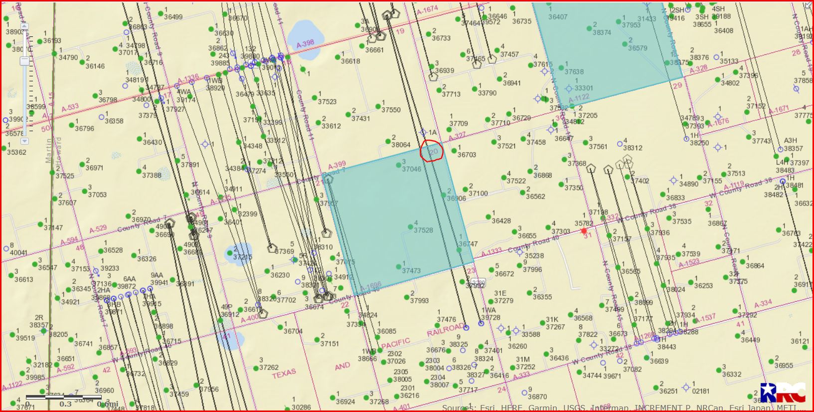
DOUBLE LEFT CLICK TO ENLARGE MAP
Clint Liles
1 Like
I was made an offer in November for my mineral rights and recently received one that is 3 times that one, so all of my relatives are selling. But I’ve asked for more time to consider. We have been receiving royalties for it, but they went really low in October and small in November compared to other months. I wonder why there is a jump in the offer by another company? Need help in deciding what to do!
Happy New Year! I see that the operator Foundation Energy received 3 recent drilling permits in the Would Have East Side Unit (new wells 1617-1619 under lease 08-37786). Do you know of a site where I can occasionally look to see if drilling commences—somewhere in between the permit approval and the first production report? Back when I still had hair there were drilling logs in the Big Spring Herald or the Midland Reporter-Telegram, but I’m not seeing an online resource. (Even though “the squeaky wheel gets the oil,” I prefer not to bug my operator.)
We are new to the world of mineral rights. How can I follow production for Waco Kid A and Waco Kid B wells?
We just agreed to lease our share Block T32 T1S (south half Section 19 and eastern 3/4 of Section 30). I can find overall production data on the RRC website but would like to follow the individual wells.
Thank you for any help.
Easiest for me was to find my 5-digit lease number(s) by searching RRC website with the operator name etc. (Those lease #s are not on the tax bill, so you have to search around.) Once you find the #s, use the “Specific Lease Query” here:
My Howard County interest is entirely in District 8, and since I’m Block 33, we should be right next to one another.
My block is 33, Section 31.
New to the forum and would like to know if anyone has information on Block 33 Section 13.
Township 2 North, N2.
I am receiving interest in purchasing Howard leases in the area of Section 32, Block 31, Township 2 North. Does anyone have an idea what is being paid for NRA? Also S/2-3-31, Township 1 South N/2 14-31 Township 1 South N/2 and SE/4-9 all 10-31-IN
Any feedback would be helpful
B McLean
Checked the RRC today on a whim and came across this info? Is this a new permit for a “child” well? What does mapping mean? Is it done already or is this something new? This is my 1st dealings with a parent/child well!!! 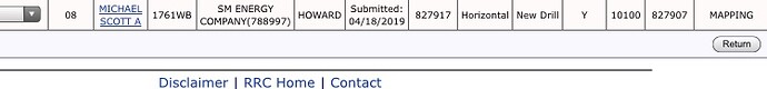
Hi Nikki, you will likely get some professional answers, but here is what I can tell you as another mineral owner trying to navigate the maps. This screen shot just cut off the API number and I’m not an owner on this lease, so I can’t seem to put my finger on Michael Scott A. Based on the permit date, I’d doubt it has a rig on it right now. Sometimes you can compare the Baker Hughes Rig Count app and tell if you know your local geography pretty well. Probably easier for people who own or live on the surface.
When a well goes into production, the empty circle of the oil permit turns green. The timing between the operator and the appearance of the color on the map is a mystery. The legend on the map does explain the color.
Most of the horizontal wells being permitted and drilled by SM in Howard are parent-child wells. We went to NARO in Big Spring this past week and did some driving around. SM is building up the structure around to support a rapidly enlarging operation. No inside facts here, just our driving around and observing.
At NARO, they discussed the benefits of planning for horizontal wells in our leases, writing in restrictions on pooling for one. When we signed a lease, horizontal wells were pretty rare and we didn’t know much about them. I imagine for many of us who are seeing permits now, that ship sailed a few years ago. They also talked about the child wells potentially bleeding off productions from a parent well. Again this would be something to be planned for in future leases.
If you have an API number, you can type it in the box at the top right corner of the map (for Howard County the number will start with 227-) and it will hit that permit. Don’t mistake the blue for the direct hit as the green of an active well. ![]() I’ve done that when I first started.
I’ve done that when I first started.
Happy mapping…
1 Like
We signed our mineral lease agreement early this year. It appears that our mineral rights were a part of an active horizontal well that started producing late last year. Are we able to recover $ for the period of time they were producing oil/gas prior to when we signed the lease? Thanks in advance for any help!
Yes, sounds like their due diligence wasn’t complete or your interest was one that fell through the cracks. Your monies are probably being held in suspense.
1 Like
I have some interests in Howard County, Texas. I paid my taxes last year online through “Official Payments Corporation”, which is the vendor Howard County uses for online payments, I think. Early April this year, I noticed a $6.00 fine and a $1.25 service fee on that fine from “Howard County.” Yikes! Did I forget to pay my taxes? No, I checked with Howard County, no balance since I paid last November. All paid up. So I call this OPC, they tell me they have no way to track it, they don’t store my CC number, I need to talk to Howard County, etc. I grew up in Texas, I know BS when I hear it. I realize $7.25 isn’t much money, but do this to enough people and it’s some money. I for one am getting a new CC tomorrow, and mailing in a check from here on out. Y’all might want to check your statements if you pay online.
2 Likes