Oil & gas discussion group for those interested in the Granite Wash. Share your experience regarding lease bonus, royalty rates, drilling activity, and oil & gas news.
I want to thank the webmasters who chose the Granite Wash (GW) to be a new group in the Mineral Rights Forum. Parenthetically, when I first joined the forum, I was somewhat surprised that the GW play was not listed as a separate entity since it has great potential to produce way more gas and oil than it has to date. Depending upon the maps (and articles) of the GW that you check, it stretches roughly 130 miles from the eastern Texas Panhandle into western Oklahoma and includes several counties (especially Washita, Beckham, Roger Mills, Custer, as well as parts of Caddo, Grady, Stephens, Comanche and Kiowa ) Of note, according to shaleoilplays.com in a recent article entitled "Granite Wash Tight Sands Play" ( and other such plays), may be the "new shale gas" and "...though they present many more challenges to development than shale plays do. There are believed to be even vaster resources of 'tight sands gas and oil' than shale gas and oil in North America." If this is true for the GW play (and the price of natural gas), then it is likely that we mineral owners will see increased exploratory activity in our respective areas and lots of horizontal wells drilled. As many others have posted on this website, do not sell your mineral rights unless you really need the money. BTW, I look forward to reading your comments about this new group.
P.S. I especially want to know if my info is incorrect. Please let me know so my next comments will, hopefully, be more accurate. I have a few more thoughts about the GW play that I think you will find interesting.
P.P.S. I just noticed my first mistake. The Granite Wash (GW) play is about 160 (not 130 as I wrote earlier) miles long and 30 miles wide. I apologize for the error.
Thomas
Where are you located within the Granite Wash?
Dj
My siblings and I own the NW4 of 1908N19W in Washita County. We recently (2012) inherited the property, including mineral and surface rights. Tom
Tom,
As a fellow mineral owner in 08n-19w Washita County, OK am happy to have a forum to exchange ideas.
I personally think that us Anadarko basin owners may well be sitting on top of significant hydrocarbons, but also think we may well have to wait many years before we see them produced. The oil companies have spent big bucks on shale plays recently and either have to drill that acreage (in order to hold it by production) or lose it. In contrast, much of the Anadarko basin is already held by production. So company XYZ may have long ago drilled through shallower formations (including oil producing formations like the Hogshooter) to produce natural gas. Just not in their economic best interest to get too busy here. As long as Anadarko acreage is held by production they can more profitably drill their pricey shale propertIes now and get around to drilling Anadarko at their convenience.
I appreciate your comments, especially about the Granite Wash now having its own site for us to chat w/ one another, John. I agree that those of us w/ mineral rights, particularly in the Deep Anadarko Basin, will likely have to wait for our considerable oil and gas deposits to be developed for the sound reasons that you listed. However, as we both know, if gas prices rise sharply and the oil companies do not find enough of what they are drilling for now, I think they will look at other nearby areas to explore, including to the south where our parcels are. As "Mick" Scott noted,..."[our properties] are on the southern edge of that 'play'(Chesapeake Granite Wash), however, and so are certainly not 'goat pasture' ". I like that colorful description of our land and totally agree w/ him. Tom
My grandfather homesteaded in Kiowa County (near Gotebo). Several members of my family now own mineral rights to the olde Homestead property. For more than one year, our mineral rights have not been leased by any oil or gas exploration - production enterprise. Considering the lucrative production from Granite Wash and Colony Granite Wash, we are perplexed at the lack of interest in leasing our property? Any comments, about 'why' the leases have lapsed in Northern Kiowa County?
Robert, welcome to the newest group in the Mineral Rights Forum. I recently started it because the Granite Wash included so many of us in several different Oklahoma counties that it would be nice to have one site to exchange ideas,etc. Hopefully, other mineral rights owners, like you, will soon join us to discuss items of mutual interest. In any case, where exactly does your family own mineral rights near Gotebo? If you provide the section, township, and range, I can make an educated guess why you folks are not currently leased. I look forward to hearing from you. Tom Senter
This is a fascinating presentation made by Ed LoCricchio, who was the chief geologist of Cordillera Energy (which merged with Apache in 2012). Ed provides an optimistic assessment of the Granite Wash Play (he puts the total recoverable resources potential of the area of 500 TCFE with 114 BBOE, including NGLs), based upon a unique stratigraphic framework that he helped to design. Of note, he believes there is at least fifteen separate reservoirs in the Granite Wash, rather than the commonly accepted three. I think that you will like what he has to say about the Granite Wash and its future. Don't sell your mineral rights! Please give me feedback.
Reply to Mr. Senter: My grandfather's homestead location is given by:
"This 'locator map' shows the location of Ye Olde Hinton Family Homestead in Kiowa County, Oklahoma. From central Hobart, go north 4.5 miles, thence east 6.5 miles, to the center of Township Section 10. The Hinton Homestead is the N.E. Quarter of that section."
Hi Robert,
Is your property due north a few miles from Gotebo?
Tom Senter
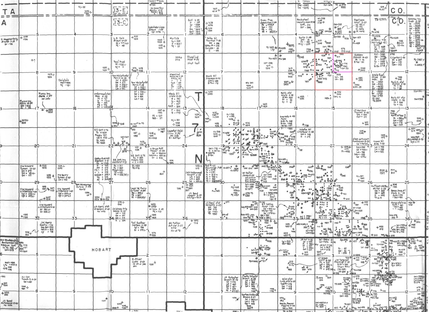
NE corner of the section outlined in red ink. I believe it is more like due West of Gotebo?
Thanks for the map and marking your parcel, Robert. It helped me to figure out what I think is the location and the legal description of your property: NE4 (which part of the quarter?),Section 10, Township 07N, Range16W (of the Indian Meridian). The shorthand version is NE4 of 10-7N-16W. Does this match what your paperwork says? In any case, many of the nearby wells that I found (active or inactive) are several miles due west from you folks. There are others to the south and southwest that are even more distant. There a few northeast of you, again several miles distant. Have you done any research yet about the wells in your area, including drilling and production info? At any rate, I suspect that your land, like ours (NW4 of 19-08N-19W in Washita County, is near the southern boundary of the Granite Wash Play. Currently, the producers are working leased areas where they know hydrocarbons are (check out John Doe's comments of 8/27 below) and are not yet looking to the south where many of us, including you and I, have mineral rights. If you have not done so already, click the link I posted yesterday and read what Ed LoCricchio said about the future of the Granite Wash. I believe that you will be encouraged by his innovative work to be patient and hold on to your mineral rights. Tom
As shown on the map, several (shallow?) wells have produced oil from the Hinton Homestead during years gone by. Current thinking of many petroleum engineers, is that the oil produced from shallow wells has percolated up from deeper formations (perhaps, over a period of millions of years). For example, the shallow production from the Smackover in South Arkansas - originally sourced in much deeper geologic formations, now known as The Smackover Brown Dense. The mineral rights on the Hinton Homestead have been leased as recently as January, 2011. And the Hinton heirs are perplexed - with the development of the Colony Granite Wash, a few miles north, why the contra-indicated lack of interest in leasing the mineral rights of the Hinton Homestead?
Robert, since there were producing wells in the past (when were they active?) on your grandfather's homestead, I reiterate my recommendation to research them for drilling depth, the soil composition encountered as they drilled down, production data,etc. and do the same for the wells that are closest to your property. The information obtained will help determine why you are currently unleased. BTW,there are people who can do this work for you. I have some more thoughts that we can discuss if you respond to my friend request sent earlier today. Parenthetically, I do not want our lengthy comments (especially mine) to comprise the bulk of what is posted on our website, as others have much to offer our group.
Tom
Tom - I really don't want to get into the nitty-gritty of core analysis, and other technical considerations. For the Hinton property - I believe the wells have been plugged for circa 50 years? I was more interested in the political aspects - such as dry holes in the 8,000 to 12,000 foot depth strata? In northern Kiowa county - within the past few years? Also, is everything else 'leased up' in the vicinity surrounding the Hinton property?
Robert, just by learning that the wells on the Hinton property have been plugged for 50 years or so means,obviously, that they were drilled before fracking , horizontal drilling, 3D seismic surveys, online well log databases, and MRI studies. However, to tease out the depth limits for more recent dry holes, you'll have to obtain copies of the 1002 forms (well completion data) for them from the OCC (Oklahoma Corporation Commission). If you need help w/ this, let me know and I will give you the contact info for someone who can do this for you. Regarding the lease status of the area surrounding your property, it appears that there are currently no active leases. Finally, since I am uncertain what political aspects you are referring to, I don't quite know how to respond except to say, it's all about the economics in the oil and gas industry, as you know.
Tom
P.S. Your parcel is in 17W, not 16W. I apologize for the error.