I would like to ask what the significance of the fault underlying the North fork of the Red River in Beckham County near Hext is other than the fact there seems to be no activity (leasing or drilling) south of the fault. Can someone explain?

Using Google Earth to search for oil production pads near the Hinton Homestead in Kiowa County - I discovered this 'improvement' on Section 10. I don't recognize this installation !? Looks like two pads. The Eastern pad has an office/lab?/shop? building - with several vehicles parked in proximity, and several (4?) large trucks (bulk solids type transport?). I don't recognize anything on the Western pad? Looks like several trenches radiating from the North edge to the Western pad? Does anyone recognize this type of installation? What is going on here? The date on the Google image is March of 2012 (a little over a year ago). Educated guesses might be helpful? Thank you.
This looks more like an electrical substation
Tom, thank you for the link you posted on Saturday the 7th, to Ed LoCricchio’s publication on stratigraphic framework and controls for the Granite Wash Play. I am currently finishing my Process Technology degree and have just completed a research paper for one of my classes. While searching for a unique subject, I investigated different methods of lithologic-stratigraphic data standardization for well logging (using the same terminology for labeling types of rocks and soil found while drilling oil and gas wells).
The problem I kept encountering was that the terminology used by different geologists in hydrocarbon exploration over the years was never the same – even for wells located near one another – and radically dissimilar in many cases. The explanation for this situation, in my opinion, has two possibilities: lack of information or lazy geologists.
The exploratory geologist’s job is now easier, at least with “modern” oil and gas wells (1970s to present), because most of the work has already been done by various agencies for determining topography and surface geology. That leaves only one critical task for the on-site geologist: stratigraphic classification and recording what types of rocks and soil come out of the ground while the well is drilled. This information is important since it can reveal how big a reservoir is and whether other wells could or should be attempted in the area. Also, it partially reflects why geologists in the oil and gas industry make so much money. However, from my study of the quality of many well logs that I’ve reviewed, many geologists were/are overpaid.
But Ed LoCricchio’s paper is literally the Rosetta Stone for the Granite Wash Play! Ed and his team have successfully standardized stratigraphic labeling terminology from 30,000 wells in the Granite Wash; creating one master list for the rock and soil layers in the Granite Wash Play. This is an amazing feat, akin to a single translation dictionary which converts Russian, Spanish, Albanian, Latin, Greek, and Farsi into English.
I am currently considering revising the premise of my research project after realizing the implications of his innovative work. Specifically, future oil and gas wells could be predicted with a reasonably high degree of accuracy and success. Even old wells which have been abandoned for years could become productive, since LoCricchio’s system could reveal a potential oil or gas reservoir only a few hundred feet below the depth where the original well was terminated.
In fact, it is surprising that the oil and gas companies would allow LoCricchio’s work to be accessible to the public, as anyone with mineral rights in the Granite Wash Play could use Ed’s method to estimate the required depth to oil or gas with a very small margin of error. “http://www.searchanddiscovery.com/documents/2012/110163locricchio/ndx_locricchio.pdf”
Thank you again for making this link so easy for me to find. From everything I’ve learned about the oil and gas industry in school, I predict this tool will make a lot of money for many mineral rights owners. Also, it will likely become a regular method of well exploration, especially for tight sands oil and gas plays, like in the Granite Wash.
Clayton Simpson
Clayton, welcome to our discussion group. I appreciate your praise for Ed LoCricchio's nifty method to find promising locations for gas and oil deposits in the Granite Wash Play. As you stated, Ed has given mineral rights owners a new and effective way to help determine what hydrocarbons are laying under their property. Thanks for your insightful comments.
Tom
Kirk, in response to your question concerning the Beckham County Fault, the USGS information I've found suggests that it is a "normal" fault which so far has only been significant to the water supply. Water wells dug on the south side of the fault have a high gypsum concentration in the water, and wells on the north side yield very pure water.
In relation to oil and gas wells, faults can create traps for hydrocarbons to accumulate in, but in a tight-sands area, this is probably not something you would expect to see - due to the low porosity of the rock in the area, making migration difficult.
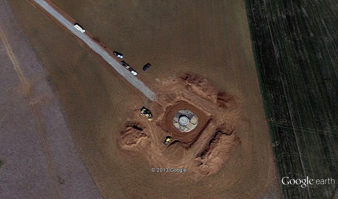
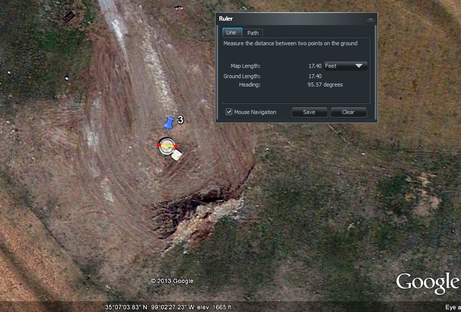
Making inquiry about this Mystery Site in Northern Kiowa County Oklahoma. The East-West road, just to the north of this site, is the Kiowa-Washita County Line. Question: What is going on here? Looks like a square 'tank' has been excavated (bulldozer and articulated front end loader)? Mounds of excavated earth on three sides? At the north end of that access road, are another 5 or 6 cars and trucks. This doesn't look like an oil or gas production site. It looks expensive? Perhaps a disposal site for hazardous waste or chemicals? Perhaps a disposal well for by-products of Fracking operations? I will be interested to read any reply to this inquiry. Thank you.
This image (below) was extracted from Google Earth - with a date stamp of 4 March 2012. So the picture is about 1.5 years old. Maybe this is where some of the Granite will be Washed !?
Robert, I cannot say for certain what is going on, but I can tell you it probably has nothing to do with oil or gas. Gas storage tanks are typically round-ish due to the pressure involved, but even a large gas storage tank is generally not going to be cylindrical in shape (except for propane).
Oil storage tanks can be cylindrical, but they will typically be buried horizontally not vertically, to reduce costs.
Water tanks can be and are buried vertically to take advantage of gravity causing head pressure, but this tank is pretty big. I used one of the trucks nearby to rough out a length measurement, and assuming a typical pickup truck is about 20 feet in length, this tank is about 50 foot in diameter.
For a storage tank to be worth the effort, I'm assuming the tank is at least twice as long as it is wide (diameter), which puts the length around 100 feet. So now we're talking about a 100 foot long tank multiplied by pi times the radius squared = 12,566 cubic foot tank. Multiply by 7.48 to get gallons = nearly 94 thousand gallons (93,996 gal).
If the tank is for water, the owner is a hell of a pessimist. If the outer portion of the structure turns out to be cement, surrounding a 20 foot diameter tank, then I'd start to get curious. Honestly I can't think of too many reasons to shield a vertically buried tank with cement. Somebody call Mulder and Scully.
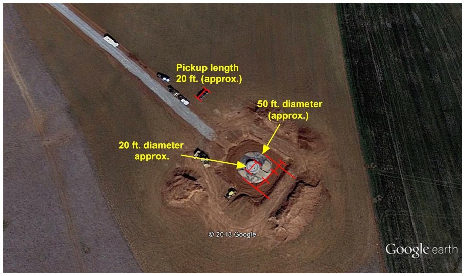
P.S. I knew I should have double-checked my math before blindly posting. A fifty foot diameter tank has a 25 foot radius. Pi times 25 foot squared = 1,963 foot squared, times 100 foot (length) = 196,349 cubic feet. Multiply by 7.48 to get gallons = 1,468,694 gallons (34,968 barrels of oil). Still, it doesn't look like an oil or gas company storage facility.
Clayton, thank you for your comments. I hadn't considered that the large circle would be the perimeter of a tank. I thought the large circle is a pad of some type - perhaps the same crushed rock or clay material used on the road surfacing? I had interpreted that the smaller inner circle (looking something like a button?) was the site of the 'major improvements' being installed at this site. This is really quite puzzling? Surely, the EPA wouldn't ordain this expense, just to remediate an olde, abandoned, 'leaking' oil well? A lot of money is being spent - it must be something 'important' !?
After staring at the picture since last night, I've come up with a different theory. I'm beginning to believe it was a reinforcing job of an existing ... well, whatever the 20 foot diameter object is.
Looking at the construction equipment, I see what looks like a bulldozer and a loader - neither are used to dig deep holes. The 3 piles of dirt around the site do not cast a significantly longer shadow then the pickup trucks, which means they are not more than 8-10 feet high - not enough dirt to bury a huge tank.
It looks like dirt was removed from around the object, something was done, then dirt was replaced - but less dirt than was removed.
Those white objects in the beds of two of the trucks could be water tanks for making cement. However making a cement pad that size is costly, and why do it in the first place?
The inner object makes more sense as a 20 foot diameter tank, but seems a bit like overkill to throw that much material at a well.
It's still a mystery, but at least it doesn't look like the property owners are renting space for nuclear waste disposal.
p.s. Robert, could you post another picture of the site zoomed out to show some landmarks so I can locate the site?
There are some out of service missile silos in the area....
Clayton: Try this image locator: On Google Earth, locate the intersection of Highway 183 with the Washita - Kiowa County Line (almost due north of Hobart). Count to the third section East of that intersection, on the South side of the county line. My mystery image was extracted from approximately the N.E. quarter of that section.
Sorry for the delay, school was cutting into my duties.
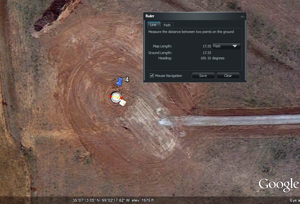
Robert I finally got time to look into the mystery site, and it is mysterious indeed.
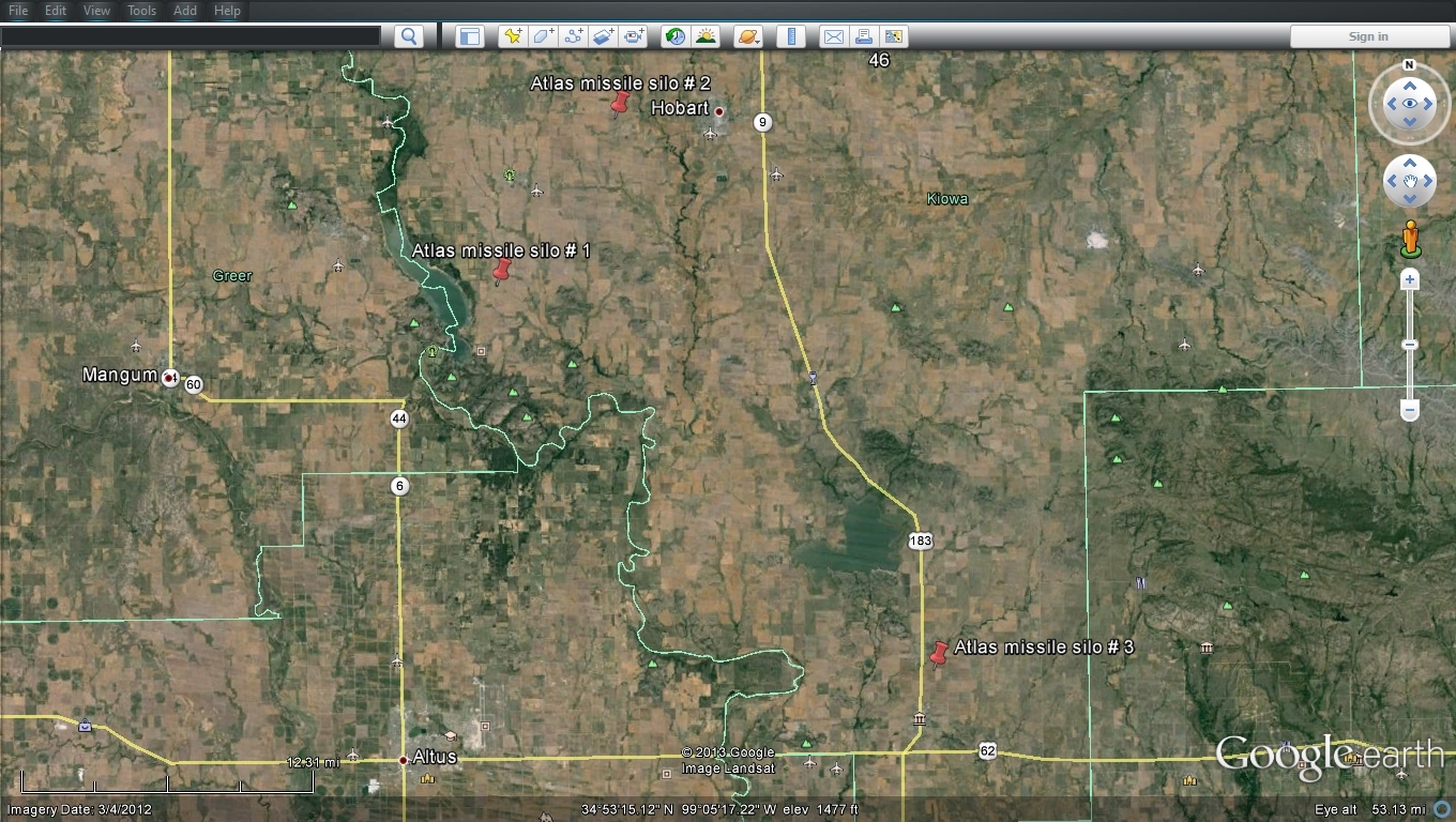
I first thought it could have been an abandoned missile silo, there is even a federal program to clean up contaminated silos around the US called FUDS (Formerly Used Defense Sites or Funding Utterly Dumb Stuff - whichever you prefer). There are only 3 listed silos in Kiowa County, and they are all south of "the site" as shown below.
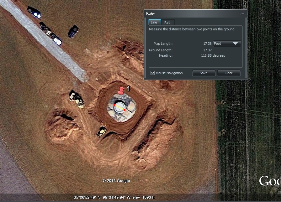
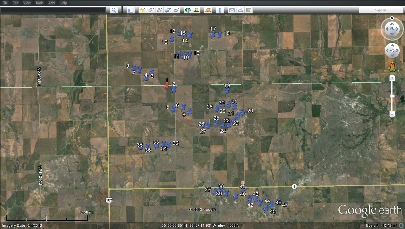
I found the spot on Google Earth, and began scanning the area, finding 4 more sites (not under construction) within a mile. To make sure they were all similar, I used the ruler tool to measure the diameters, and guess what? All of them have a diameter of approximately 17 feet and change (shown below).
I sort of went crazy after that, bouncing around looking for more sites, and ended up finding nearly 50 of them in clusters before running out of gas. There doesn't seem to be a logical pattern to their arrangement; some are in lines, and some are isolated. There certainly is a lot of them though.
I suppose it's possible they could be related to a pipeline somehow? Maybe part of a pumping system? It's a big stretch, but I don't have a clue. All I know is that a LOT of cement was involved with each one of them, and that costs a ton of money, which can only mean oil/gas companies, state or federal project.

To Clayton: Like, "WOW" !!!
Thanks for all your informative comments regarding Robert's mysterious site, Clayton. IMO, the only thing left to do is to visit a site or two. Does anybody live close to the one that Robert first found? If not, let's move on to another topic.
FYI, folks. I was recently told by a very high executive in a major domestic oil company , not currently leasing or drilling in the Granite Wash, that the petroleum and gas industry views this as a major threat to them. Therefore, mineral rights owners should, too. The same person advised me that those who are lobbying the Fish and Wildlife Service (FWS) to consider listing the lesser prairie chicken (including those in Western Oklahoma) as "threatened" under the Endangered Species Act ultimate goal is to totally shut down domestic oil and gas production. BTW, sprague's pipit is apparently the next bird in line to be considered a "threatened" species by FWS. When it migrates south from Canada, the bird crosses over Oklahoma. I urge you to click on the link below to learn more about this topic. As always, your comments are welcomed.
http://www.reuters.com/article/2012/12/01/us-endangered-prairie-chicken-idUSBRE8AT1E320121201