@Don_Bray Can someone show me Grady County Section 13 6 N 5 W on a map that I can see other locations close around me? I know Section 18 is next to me in McClain County I think, just trying to see how far apart are the sections around me. And if any activity is going on around me in this area. I looked at Grady section map but lots of 13’s wasn’t sure if I was seeing the correct one. Thank you each for your help.
Here is a map of 13-06N-05W in Grady County. There are several wells in the sections to the south and southwest of Section 13-06N-05W. Yes, Section 18-06N-04W in McClain County is adjacent to the East.
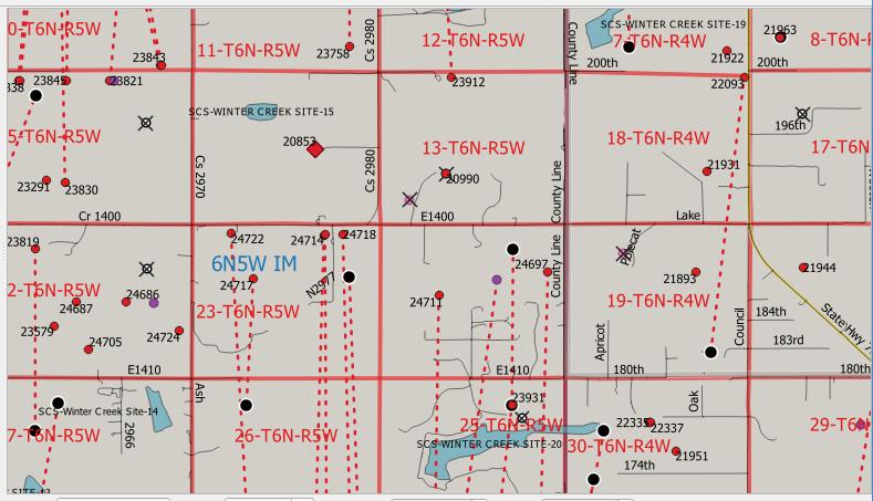
@PeteR Thank you for your help. Is that Section 24 directly below Section 13 6N 5 and is that 16 to the West? Are the red broken lines horizontal wells and the red dots vertical ones? Thank you for your help.
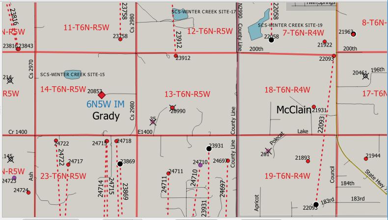
@Vickey1956, yes, the broken lines are supposed to indicate horizontal wells. Dots without broken lines are vertical wells. Red for oil, orange for gas, violet for not sure. Yes, the section directly to the south is 24-06N-05W. Zoomed in a little more to catch the API numbers better.
@PeteR Thank you again.
@PeteR I was doing some reading in regards to the Springboard and was wondering if I see Section 13 Township 6N Range 6W was included in the Springboard, is Section 13 Township 6N Range 5W anywhere near that or no? I really don’t know much about this stuff so sorry if this is a silly question. Trying to figure out if there is any current or future activity near Section 13 Township 6N Range 5W. Thank you again.
@Vickey1956, 13 Township 6N Range 6W would be about 6 miles west of 13 Township 6N Range 5W. Not sure what you are referencing with the Springboard. I did notice that 13 Township 6N Range 6W has some newer wells (2019) that are drilled into the Springer formation.
The map we were looking at shows current and past wells, but not future. Finding possible future activity in a specific area is often not easy to see without some detective work. You can search the County records for recent leases in the area, or search the OCC dockets for recent permit applications. Horizontal wells are easy to miss since top or bottom hole locations may be referenced but not the well path, which can be two or now three sections long.
@PeteR Thank you. I was just curious back when all that drilling was going on how far away my section was. Thank you again for your help. Yes, the Springer formation is what I meant.
Where did you download that map? Thanks - Kit
Complete dummy here. How and where do you find these maps?
@PeteR could you possibly share where someone could find these maps? Several members of the forum are asking, and I have no idea. Thank you for your help.
@Vickey1956, @Turfsurfer, @Kit_Farwell, those maps aren’t available online. They are homemade using OCC data and publicly available shapefiles in QGIS (free GIS software).
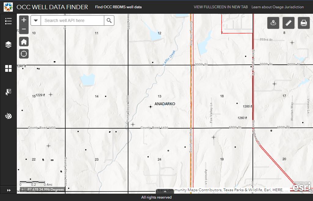
Here is the link for the OCC map: https://gis.occ.ok.gov/portal/apps/webappviewer/index.html?id=ba9b8612132f4106be6e3553dc0b827b
Here is a picture of that area with the OCC map:
Thank you for your response.
I am confused about the map. Is the map referencing the Anadarko Basin?
@Graceful99, you are correct. That reference is to the Anadarko Basin.
@PeteR Thank you for sharing that information.
Is there any activity on Section 24-T9N-R8W? How would I find out?
Citizen Energy was leasing in 24-9N-8W in 2022. Looks like the Norpo 1H-25-24 was completed in June 2022. If your name and address are correctly filed in the county courthouse with the clerk of deeds, you should have gotten the mailings. Division Orders should have come out by now. The surface location of the Norpo is in 30-09N07W.
Thanks! Appreciate the update.
@M_Barnes I received an update from my subscription showing 2020-002299 final orders and order #73172 and then another update showing a mailing list going out to 29 people. It also shows it is closed so it is not listed with the other four case numbers shown to be heard in March. Can you enlighten me? Do they drop to closed as they are approved? Thank you for your help. This is Section 13 6N 5W Grady County. I’m still learning all this.