I’m getting offers on mineral rights on Grady Section 4-05N-05W. Anyone have knowledge of pending new activity on this property?
Thanks for your time.
I’m getting offers on mineral rights on Grady Section 4-05N-05W. Anyone have knowledge of pending new activity on this property?
Thanks for your time.
I do not see any new OCC orders, but most offers come before the bit. So I might guess that someone thinks there might be infill drilling on sections 4 & 9.
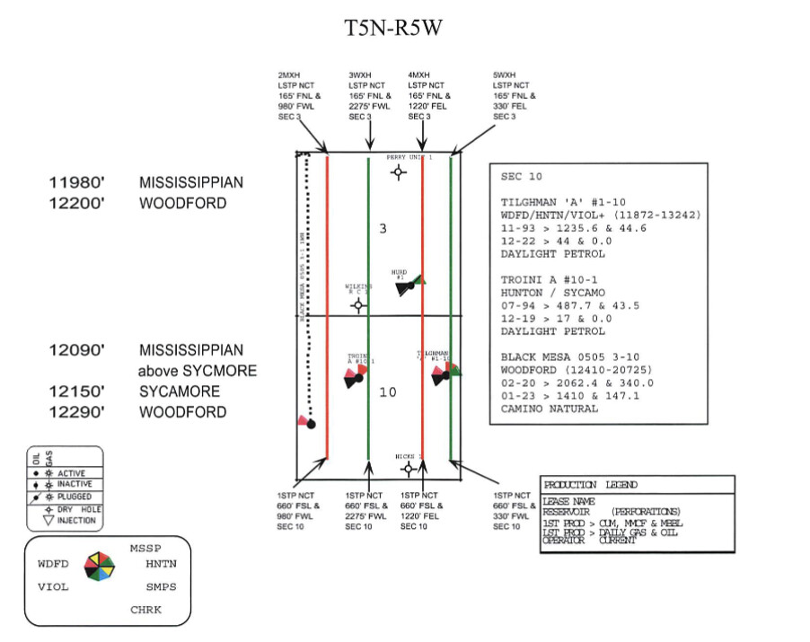
I have received a couple of offers also to purchase my minerals in 10-5N-5W. The current producing well drilled by Camino a couple of years also was drilled to Section 10 and 3. The well, as I understand it, actually sits on Section 4. Martha, am I correct so far? Would the interest I am seeing in Section Ten be in any way related to the interest in Section 4 that Lee Cooper mention in his comment above or could this be totally unrelated and separate? Hope my question is clear. Thanks for all your help!
The surface location for Black Mesa is in 4 but the perforations are in 3 & 10. So the interest you are getting in 10 is probably similar to that of 4/9 (Great Plains) and 3/10. Potential infill wells might be in the “wind”.
Good morning, a landman from BCF just offered me $15k/nma for part of my interest (1.0466 nma) in 10-5N-5W that has a minimum 1/5 royalty. The other HBP interest has .4 nma with a lower royalty. I find this offer extreme. Does the Mineral Forum have a place where I can research BCF?
Yes, I got an offer for $18,000.00 per acre. And also got a letter from BCF wanting to buy my royalties. Camino has filed for increased density so hopefully two other wells are in the works.
How do I determine if Camino included Section 4-05N-05W in the filing for increased density?
Lee- if Camino filed a density for that Section & you own in that Section, you would have been notified as per OCC rules.
Thanks for the information. Appreciate your time.
Lee, from the Increased Density filing that I received yesterday, it shows Section 10 and in offset Section 3 and is referencing the Tighman A 1-10 of Section 10 and my old vertical well, the Troini A 1-10 in Section 10. I don’t know what offset Section 3 means. Also in the location, the Range portion, gives (Range 5 West of the IM). I don’t know what the IM is. Martha, would you please comment on the offer I received and explain what these things I mentioned mean?
BCF is a buyer who frequently sends out offers when there are increased density cases. The forum does not have a place to research BCF, but you can use the search icon in the upper right corner to see other comments about them. They are one of many companies that make these sorts of offers. For my family, I use them as a canary in the coal mine. I mark through them and say “NO” and put them in my tract files for information purposes only.
IM means Indian Meridian.
What case number is at the top of the Increased Density filing? I need to read it before I comment.
Offset section 3 means that it touches section 10 (“contiguous” is another word for it). It is immediately north of section 10.
The case no is 2023-. Also got something called “Exception Under” with the same cause number and OAC 165:10-3-28(c). The offer I got for $18,000.00 per NMA is from Evanston Acquisitions, LLC, out of Tulsa.
I need the complete case number. It is at the very top of page.
2023-001747 filed 05/25/23
Graceful99, Do not be concerned about the Exceptions cases. They are about what the allowables will be for gas or oil for the additional wells. You have no input into the answers on those.
You are about to get four more horizontal wells. The stick figures below show the approximate locations. They will probably use the same well pad in section 4 to save money. The individual case files will give the approximate splits for each well for section 3 and section 10. The final splits will be determined after the wells are drilled and surveyed.
Who would have thought! Thank you, Martha! Don’t think I will be selling for $18,000.00 per acre.
Received another “Exception Under” today. It mentions my old Troini A 1-10 well which has not produced anything for at least two years but says it is operated by Daylight Petroleum LLC. Do they still have “Operators” even if they are not producing?
Martha, the increased density I looked at is asking for a permit for two increased density wells. Where did the four you mentioned come from?
The way to figure this out is to put the OCC case documents that you receive in numerical order by case number. Then for each case, read them in date order and then flip to the back of each document for the exhibits where they often show you the well paths. If there is more than one formation, then you may get additional increased density paperwork. I found this map on one of the case documents. Don’t remember which one.
Look for the surface location of the wells on the exhibit. Then go to the OCC well records site and look up the permits in the section for the surface location. It may take a while for the permits to show up because the horizontal cases have to have an order before they can file the permit. They may not always drill all the permits. Permits are Form 1000, Spud 1001A, Completion 1002A. Sometimes the surface location is in a section next door. Maybe 4 for this set. Or could be sec 33 or 34.
Yes, an operator can still be listed for a well that is not producing. They are stlll liable to plug and abandon the well.