Have you heard any updates on the discussions between EOG and KEW to develop units north of Pecan?
Heard there was a “deal”, but there are a lot of tracts that are only partially leased by KEW… meaning a tract they leased does not have all mineral owners leased, so will take time to do so… plus they are not using all KEW leases, only ones within a planned unit.
Also the talk is not putting a unit above Monster Rock, but shifting the unit 1 to the west, so one above Reimers and one to the west of that and then going up. This would be a 4 unit one pad situation, but not in line with the others. Again, this is under discussion depending on results, but they had an extremely thinning of the upper EF in Monster as they went east.
Have to stay tuned for results, and the economics will be a big part of the decisions going forward in this neck of the woods, going into Fayette County.
As is the case in plays like this, it is all about the rocks!
Thanks, interesting info. I am going to be keeping my eye on this seeing as this certainly impacts my family’s acreage!
When you say “above” Monster Rock are you referencing to the North of Monster Rock? What about toward the south of Monster Rock? Is that one still planned in line with Monster?
Does anyone have any information on the pad for Kainer B unit? Seems like it’s pretty deeply on private property. Permit is still on hold.
Crud. This appears to be a reply to an unrelated thread - unintended.
Yes, a pad/unit north of Monster is in question. Actually, a pad/unit anywhere north of Pecan pad “was” in question because EOG did not have all the leases.
The initial unit maps from early 2024 are the ones being permitted almost exactly as planned. However, they were all still on hold until testing. After Francis well EOG “proved” up their acreage north to the Lavaca River. Blackshear results “green lit” the 2 units under it, and the 4 units above it (future CR240/FM 957 pad).
Pecan pad looked promising, and at this time there are still plans to do the south 2 units from Pecan Farm pad, and another 4 units below that (future CR229/CR263 pad).
Although some talk of westerly movement, mainly on any units above/north of Pecan Farm.
There was talk of moving some of the units west just a smidge above Blackshear, but that has not been mentioned lately. If you look at how the units are designed, the 4 wells on one pad for 4 units goes from Francis pad toward the north, and plans are to make a pad at EVERY 4 corner mark eventually to drill out the units having 4-6 wells each unit. So every pad would have 8-12 wells on it when done.
So when a pad site for the 4 units are permitted, where they meet again north and south 4 corners with the next 2 units, the pad site is already planned and approved by surface owner, even though this would not be done/drilled/permitted until 2027 or later, as they try to hold all leases with one well before option payments due.
I was given a map by Redhawk when I signed my lease in July ‘24. Admittedly it’s a one-pager showing only ‘my’ unit, but you can see from the margins that apparently they laid out a unit grid over the entire area regardless of who’s leased to who. In fact, if you get out the magnifying glass you’ll see that each tract is already numbered within each unit (I have a number).
Also for ‘my’ unit at least, the directional orientation (slope/slant?) looks to be exactly that of the pecan pad. This doesn’t appear to be true for Blackshear/Parr though. They’re too E-W.
So to your point, it would probably save a large amount of staff work if they just shifted any units above the Pecan Farm ‘up’ one unit to the NW on their grid if they decide to do that.
As an aside, I’ve started a bad weather project to see who’s leased to who and have put those on a color-coded CAD map. I’m far from finished but EGAD! What a patchwork of leases between Redhawk/KEW/Acaval. Hoping that they can get it all worked out.
Uh oh… Parr well results are out…
523 bopd in October based on 10/13 start of production
2.3 million cu/ft nat gas/day all this based on 18 production days
However… the oil numbers have about a 7-day lag, told to me by EOG
So that makes Parr at 856 bopd (not boepd, but bopd)
What Blackshear had:
1690 bopd and 4.7 million cu/ft nat gas/day
This puts Parr well at half of Blackshear production and now Parr has an 18-month payoff instead of Blackshear’s 7.5 month.
That is why EOG has been in discussion (they saw daily numbers) to move westerly a tad bit… but they still wanted to test north (monster…) and from what I heard as far as drilling issues and horizontal issues… Monster will probably be pretty dismal in comparison to the southern wells.
Again, I’ve heard the Andrew unit south of Parr and all others south are green lit as well as are the 4 units above Parr and Blackshear. But I would not be surprised if the units north of Blackshear pad change… gotta make some calls….
Thanks for posting this info - definitely not what everyone wants to see.
Lots of moving parts here as to reasons for post-frac flowback variability - including landing zone, staying in target interval, frac approach and details. And most importantly, the variability of the target interval and associated stimulated rock volume (frac’d interval) as to key reservoir characteristics.
Even with the better early production, the decline profile will come into play as to the bottom line economics of this area.
Another thing to keep in mind is that this is early in the flowback. Also, with EOG in acreage acquisition mode, they may try to downplay the results of these wells to minimize competition and reduce acquisition costs.
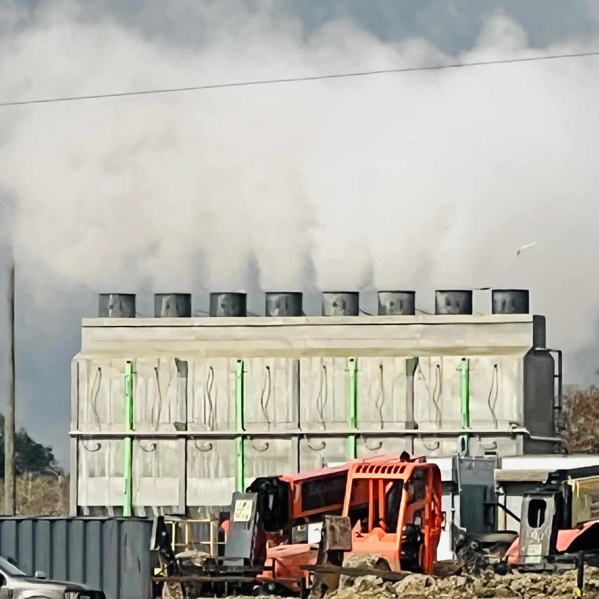
Pecan pad looking good started last Thursday cranking it on slowly but it looked not to plan. Friday better heard a few pops but no flame. Water trucks been running nonstop. I am sure gas been going somewhere was about 6 white trucks at Philips pipeline Thursday morning. Somebody smarter than me can tell what exactly that steamer does.
My Guy is unsure but thinks it’s a cooler (radiator) to cool down hot flowback water because SWD plumbing is poly to keep it from corroding and so can’t be very hot. Not to mention hauling it to the nearest SWD well.
Don’t bet the farm on it though.
1 Like
Post frac flow back may be taking longer to see gas break through - common occurrence.
The steam you are seeing probably tied to running the flow back fluids thru “cooling system” to bring down temps before running fluid thru separators (where higher temps may cause damage).
Based on log header info from deep wells in the trend, bottom hole / reservoir temperatures here should be in the 250 degree F or higher ranges.
I think your comments are dead on.
So I have some news. I am in a lease with EOG in Lavaca County, between CR 194 and CR 195 just north of FM340. I heard 10 days ago that drilling will begin early next year and there is a 7-acre pad for four wells. I am new to this and inherited the lease just after it began in 2024. I am unsure if this one is pooled and if so how big it is. Can anyone give me insight on what to expect?
All depends on what your lease says. The lease you inherited may have a pooling consent requirement or it may not. It ultimately doesn’t change anything, just if they have to notify you first before pooling you.
If you don’t have that requirement in your lease, then you could do some digging on the RRC website when their permit gets posted with the unit (I can help with that if needed). Otherwise, your lease will be pooled into the unit and when they start to produce, you’ll receive a division order to execute which shows you your percentage of the unit, etc.
These 4 units have all been permitted already…I posted this over a week ago I believe….Kenobi, Alfaro, Bruhn, Rawlins are the units name….…
You might not be listed by your name on the mineral owner section if your tract has multiple mineral owners…it would just have one person’s name and then “Et AL” meaning “and others.”
You will just have to search your tract to see if it is in the unit…..if you have the tract address I could look it up, or you can go to the Railroad Commission site and research.
Division orders might not come out until 1 month or so after production begins…which will not happen until around mid-March…they have to drill 4 wells and frack 4 wells before they start flowback/production….
I just heard that poly and other sensitive equipment is only good up to about 180°. So at 250ish that’s way too hot.
General question: What’s a Cliff Notes explanation for the difference in Bottom Hole Temperatures (BHT) from one area to another? I could understand if it’s around Yellowstone (the park not the TV show) but north Lavaca County does not follow.