Sure thing. A plat will never tell you how deep the well is, it will just show you the wellbore path and the tracts it covers, along with take points and distances from lease lines etc. Furthermore, TVD + lateral length = measured depth (MD). So when you see a big number like 23,000’ MD, that is the entire footage of the wellbore, including the vertical section and horizontal.
My experiences with TD / TVD / MD numbers on permits is that it is best to wait to see the post drill directional surveys before making any solid conclusions. Including the subtleties of lateral location vs lease / unit lines as well as landing zone / formation based on subsurface well control.
Yeah, absolutely. Things can certainly change which is why there’s the as drilled plats, etc. etc. and where the operator actually lands the well.
Thanks to both of you. I guess I was taking a look back at the Wolters well just across the county line in Fayette County. There were high hopes at the time until the whole thing became a goat rope for a variety of reasons.
I think it will be interesting to see how the Reimars and potentially others compare to the Wolters. As you pointed out, they had a bunch of drilling and completion issues etc., but if we just look at rock characteristics, I will be interested to see how it compares.
Rockman, you would obviously know more about this, but when you pull the log for the Wolters, what do you see/what do you think EOG sees? I am sure they used the Wolters log when building out their subsurface mapping. If I recall the Wolters was targeting the EF which is super thin in this area, but I am wondering if the log(s) tell a story for the AC.
The correct term is “common source of supply” or “reservoir”, not “field”. The spacing is determined by the depth of the reservoir and the intended product of gas or oil. A field can be a collection of one of more stacked reservoirs in a geographic area.
I mean yes and no. My post was responding to the RRC field listed on the W-1. In this case, it is Eagleville (Eagle Ford-2). When you are talking about the Texas RRC regulatory, it is referencing the specific “Field Rules” that are in place and typically get amended, especially for horizontal development.
Those specific field rules lay out the acreage allocation based on lateral length and oil or gas well classification. They also will give you type logs as a reference to determine if it is the proper field to permit into.
I agree a “field” can be a broad term and encompass several productive depths, but over the years the fields have “shrunk” and been better described by the RRC. It is much more of a grey area when you are testing new areas that don’t have good descriptors of which RRC field to permit into and/or no horizontal field rules. I have been out of the land/regulatory game for a little while, so I am sure it has improved since then.
Yes, if you are referring to the RCC field rules and filling in boxes, then those do determine the development.
1 Like
Came across some interesting information. On 11/6 Redhawk filed 19 more leases in Fayette County. 19 is not a particularly big number but the locations are of interest:
Taylor – 6 Whitehurst – 5 Anderson – 3 Counsel & Bell – 2 each Bostick – 1
No big news with Taylor but the others are not exactly in the area we’ve been following.
I suppose, in a very uninformed way, that could indicate that the trend is more in line with Reimers than Monster Rock, but who knows. More leases in Taylor is interesting, seeing as that’s where our lease is!
WI, do you know where in Anderson? I’m in the Anderson League and still waiting. Most of my neighbors were leased last year.
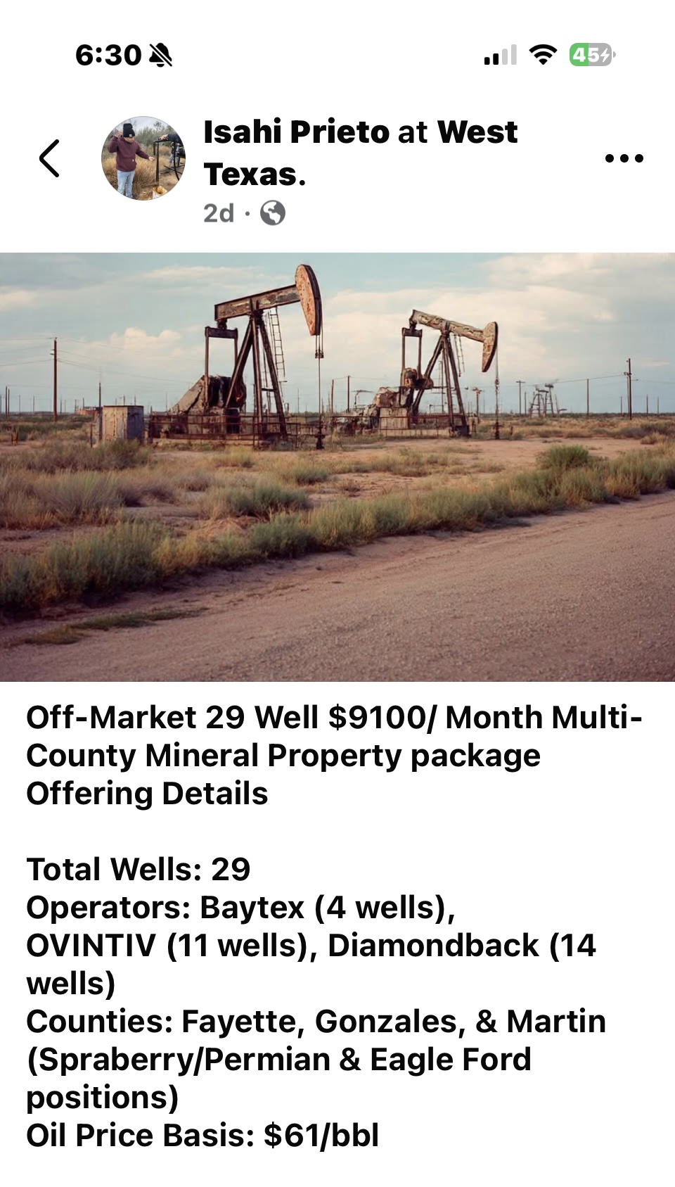
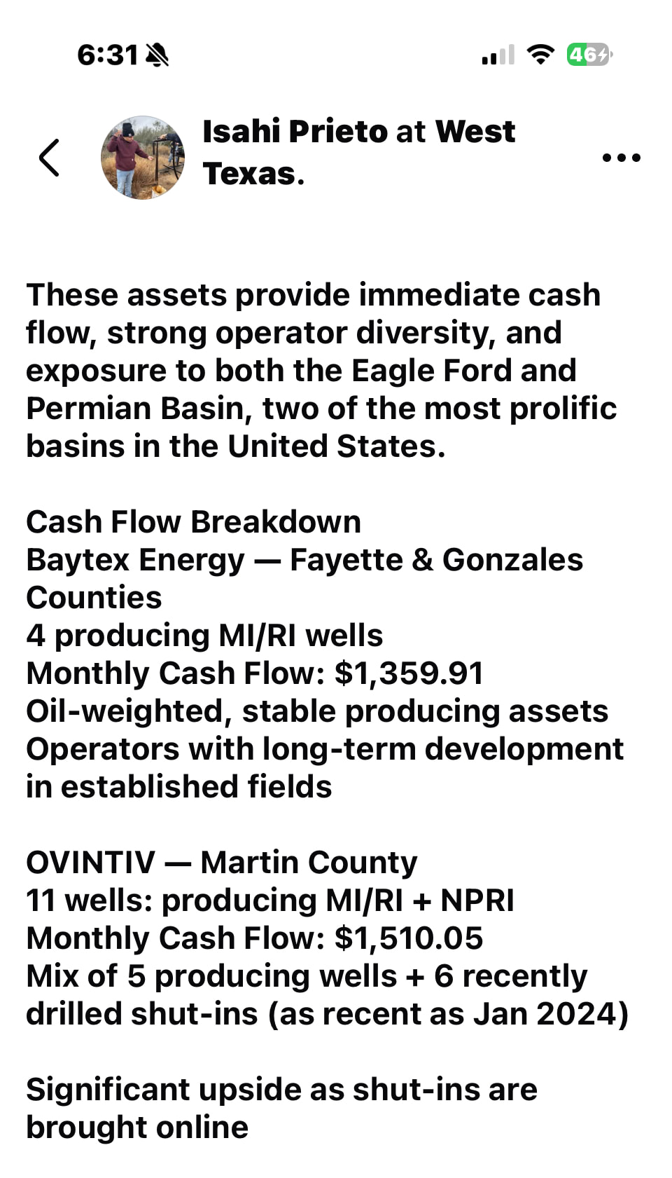
This showed up on my Facebook feed regarding Baytex selling some wells in Fayette and Gonzales Counties
Best guess is SW corner I-10 frontage. May not be entirely accurate though.
The post isn’t totally clear but I read that as someone selling mineral rights, not wellbores. It calls out the operators who own the leases on this mineral owner’s property(ies).
Public Service Announcement:
I recommend going to CourthouseDirect.com and signing up. It’s free as much as signing up for anything on the internet is free. They’ll email you a monthly list of new oil & gas courthouse filings. Their only drawback is that for whatever reason they don’t do Lavaca County.
Having said that, do your own research but there’s probably not a square inch of unleased property in the M Muldoon Survey. Rosewood and Flat Land. High hopes around Flatonia.
Thanks William, that makes sense
Gotta love it! “The Free State of Lavaca”
Thanks, WI, that was helpful.
I imagine that on the Pecan pad that flowback operations are going on now. One of the landowners said they saw a lot of fluids being hauled away.
EOG just permitted 4 new units. The 4 I had mentioned in a previous post on County Road 195 and County Road 194. The names are Rawlins, Alfaro, Bruhn, Kenobi.
To the north of these units leaves one more unit and then the unit that is south of Blackshear. EOG was going back to the Blackshear pad to drill the 2 units south of Blackshear and Parr (off the Blackshear pad), but the site surface owner is not allowing EOG to drill again on the pad unless it is a Blackshear well. The unit below Parr would be called Andrews. You would think EOG would have had this in their site contract, but since Blackshear was a “test” well nothing was included on this. In fact, to do Parr they had to sign another contract with the site owner.
So, that is why EOG is rushing the pad completion for these new 4 units. EOG is working on securing the pad to do the 4 units between Blackshear pad and Alfaro + 3 pad, just west of Breslau Lutheran cemetery. After those are drilled they should be doing the 4 unit pad off of County Road 240/FM 957.
Of course the site owner of Blackshear pad could change their minds since “money” talks.
Timeline approx. 1/15 rig #1209 goes to Alfaro+3. Then 2/15-3/1 rig #1209 goes to a 4 units pad above this, or to the County Road 240/FM 957 4 unit pad, whichever can be done the quickest and have a pipeline going to it by the end of the frack process.
After this the southern 2 units of the Pecan pad would be done, depending on results, but I heard almost either way these 2 would be done.
Also there is talk again that EOG might be sending another rig to finish all this up by 1/31/2026. It is in discussion currently. It would be sent to the “Redhawk” area.