Cliff Notes version - the deeper you are, the hotter it gets. No consistent temperature gradient - this varies from area to area based on heat flow in any specific area.
Open hole logs are the source for BHT data - this info is always noted on the log header (i.e. maximum BHT). This temp will tend to be a bit lower than the “true” BHT due to cooling of the wellbore tied to drilling fluid circulation.
For comparison, the deep Haynesville Hz play in Robertson / Leon Counties has BHTs in the 350 to 400 degree F range.
Logging tools and other equipment can be very temperature sensitive. And special (and more expensive) tools can be required.
High temps have impact to drilling fluid, frac fluids and proppants, cement for casing, etc.
If you ever see huge fans on flatbeds, these are probably chilling units for high temperature gas wells.
Yes, those water trucks coming from Monster and Reasoner aka Pecan Pad CR226 right by my house. Talked with a guy this morning; he said flowback water was coming from both wells. Also, he said no gas going anywhere and yes, streamer cooling water going into frack tanks where tankers are getting it. I had to do some testing on tankers. I got an infrared thermometer and putting that red laser on that tanker trailer got 70 to 108 degrees loaded; guess it depends which frack tank it came from.
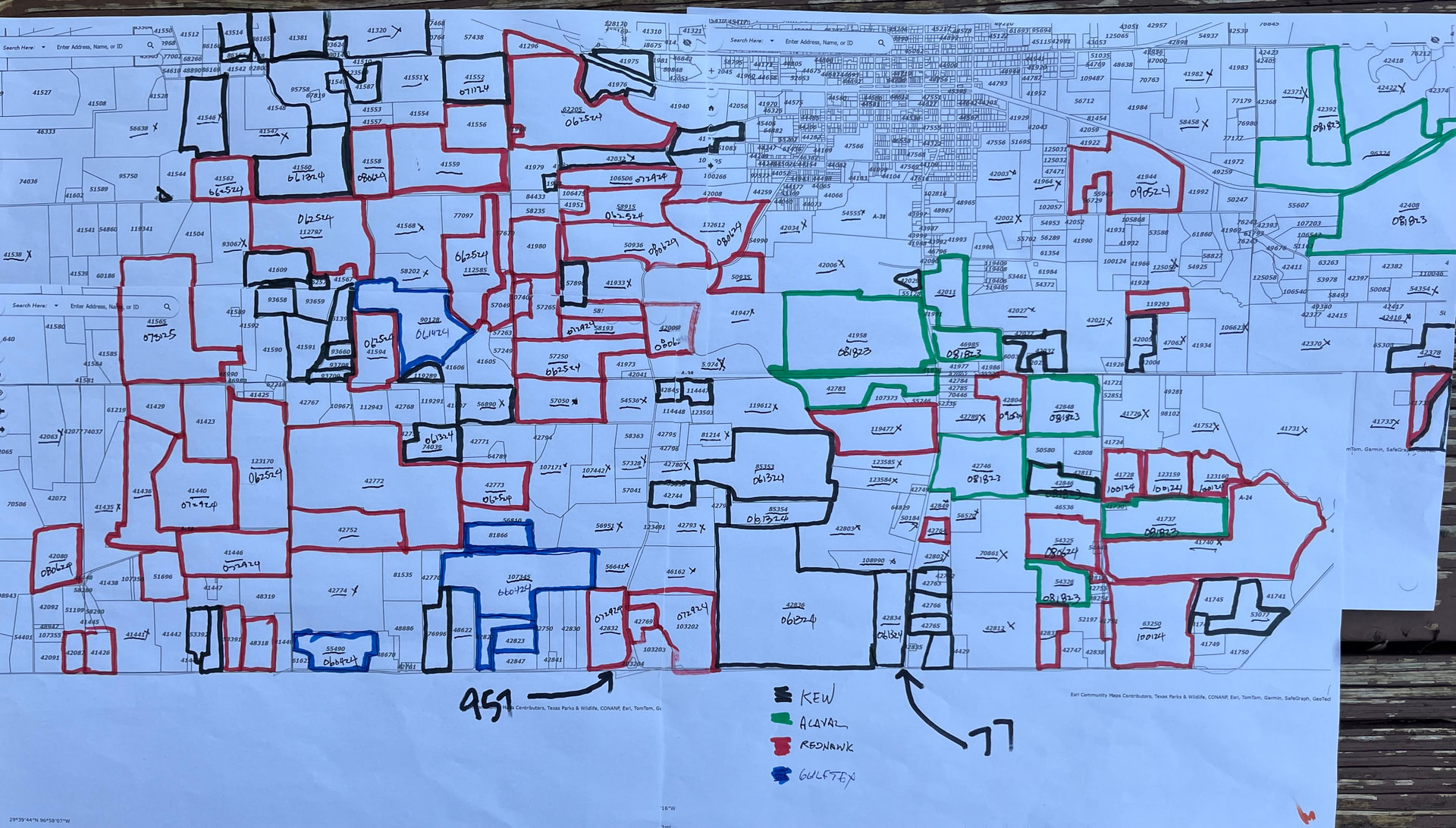
Water going to location North Flatonia and South of Moulton towards Shiner.
They process the checks on the 10th-12th of the month and mail out… usually arrives 15th-20th… unless you opted for direct deposit. Also, they have to have your completed signed off division order before you receive any payment… and they usually run 1 month behind actual production… meaning you would get October’s sales in December….
There is always this early delay and the anxiety of waiting for revenues - but once it starts, the mailbox money aspect and related happiness kicks in.
I suggest you keep track of your revenues - ideally in some sort of EXCEL file - so that you can better monitor and understand changes, production decline and other factors.
November gas $ not available yet but I would estimate $200,000
Total $1,553,591
This would give first check in January a total 22% pool of $341,790
Now just divide your total mineral acreage in this unit by the unit size of 1278.98 acres to get your percent of the pool dollars… or for this check you could just plan on getting $267 for each mineral acre you own.
Also heard some interesting stuff over this Holiday that I will share… but first does anyone know what the “Marl” is? Is it a formation, or area? Heard this several times in discussions and was unsure what this pertained to exactly? I sorta remember this term from about 6-12 years ago… but no longer remember the meaning….
In case no one else mentioned it Baytex sale closed on 12/19….
It is also a term used for the Lower Austin Chalk / Upper Eagle Ford section in the Lavaca / Fayette County area by some operators (most notably, Penn Virginia).
The $267/acre is only for the first check on Parr which includes both oil & gas revenues for both October and November. The royalty of everyone on Parr for those 2 months $341,790 simply divided by the unit acreage of 1279 acres = $267 / acre.
Now you should have your percentage of unit ownership on your division orders, and that is what you use to determine your check if you have the Revenues.
Yes, the checks for the next months will be substantially smaller as the well declines in production… and the dollars per acre will be so much lower than $267… not even $100 for February’s check… and as I was told about this unit, don’t expect another well anytime in the near future… more on that later….
Good information as usual. Decline rates and well production notwithstanding, $267/mo/acre still beats the $0/mo/acre that I’m getting so I’m still hoping that they continue with their drilling program.
I got a couple of conflicting reports about Monster. It’ll be interesting to see how that one turns out.
It appears that the flowback is completed. I have not seen a truck hauling frac water to the disposal sites on 957 for the past 2-3 days. Any news whether wells have gone on production?
EOG has started a new pad site. This one is off of FM 340. EOG left a space for 2 units between Francis pad and the Maddox pad (where they are on now), and another space between the Maddox pad and Kenobi pad.
This pad being built now would be the one for the 2 units between the Maddox and Kenobi pads. They have only 1 more left between Francis and Maddox… then EOG is DONE with their “planned” locations… only exception is 2 pads north of Kenobi, but since some of the tracts are north of the Lavaca River it could be under the “Redhawk” name… but is in the “proven” area.
The Redhawk proposed units I was told could and probably will shift from their early “test” plans, based on results.
What I heard over the Christmas holiday was that even though some wells like Parr#1 won’t breakeven until about 3 years at current pricing… they might still plan the northward trek… drill one well… and hold until prices make it economic to do another well… and these prices would have to be 40% over current pricing.
So, that is what the discussions are as planned sites go from “green lit” to now “under consideration.” This info has been given to both site supervisors and landmen have been given “specific area” instructions as well… since some of the proposed Redhawk units still have unleased tracts some due to holdouts… EOG still has some issues above Francis pad for example there is a 13-acre tract with 26 mineral owners… at $1,200/acre not much incentive to sign the papers… but mostly just a time-consuming chore…
Pecan wells really hold the key… and Redhawk/EOG already has an idea of what the results will be… just are they going to gamble or not?
I’m probably way out over my skis here but I decided to use the CAD and a lease app to try and figure out the lease patchwork in Fayette County. It only goes about as far west as St John and north to 90. The blanks are unleased or too complex for my pay grade.
I recommend just squinting at it and not trying to read too much into it.
I saw the dirt work being done on the FM 340 location. Quite impressive the amount of scrapers and the speed they were running.
I have been reading this forum for quite a while. It has a ton of great info.
My family has some minerals in the Charlottenburg area and are in the Bullard unit that is off the Maddox pad. The unit is taking a small amount of our total leased acres. My question is why this unit is only 978 acres compared to the 1,200 of the other units? That lateral is only about 1.9 miles vs 2.2 as some of the others. This brings me to my next question:
I have researched via Texasfile and Lavaca CAD and saw there is an area west of the Bullard unit, south of some matrix units, and to the east of Silver Hill (old Rocky Creek units) that is leased to EOG. One of the water ponds is in this area. Is there any discussion of development of this area? Could this be a “bolt on” that was spoken earlier?
When I read all EOG planned units are done it makes me think they might allow this area to expire in 2026. It’s about 2,400 acres. Only my guesstimate. Any insights?