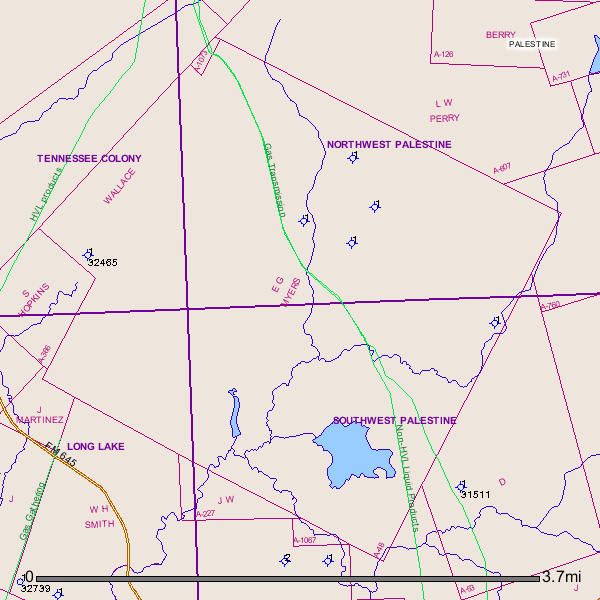
I have a large survey map of Anderson County and you will be interested to know that your Meyer Survey interest joins the Wm H Smith Survey on the SW where EOG just drilled their Autry vertical test. You may have some wiggle room to negotiate a little and I don’t think it would compromise your deal. Nothing like a little “Texas Greed” occasionally.
How would I find out about that well? If it produced.
Think you need to double check your location. If your place is off CR 2136 just north of Lakeview Lake it looks like that is at least 5 miles south of Meyers Survey A-48. Lakeview Lake is in R. Erwin A-262 and the other surveys around it are Dodd A-235 and Stibbins A-714.
If you know any of the landowners around your place I’d check with them to find out what they know about leasing. If the landman’s comment about 80% of the plot (block?) being put together means anything there should be folks around you who have already leased.
Only the vertical test was drilled on the Autry well which was just a month ago and if they like what they find from the core samples, then they will come back and drill the lateral bore. So it will be many months before we’ll know the results. You’ll need to learn how to navigate the Railroad Commission web to keep up with the progress of the well. It is easy and I’ll explain it later.
That’s the thing. We live up in Boyd, Texas. Some family left that mineral to my mom’s dad. And when he died we never knew anything about it. My mom’s dad owned property down there but it got sold. So as for this property my mom’s not sure where it’s at. On the map she showed me it’s kind of northwest of Lakeview. North of 2136 too. But that’s where she thinks it is. But the lease says Meyers A-48. Done in 1980.
Is there any way you would have those surveys on email where you could send it to me?
Randall
I noticed this EOG Autry Well #1/vertical/ API 001-32739 is not too far west of your A-48.
GIS Map of your A-48 in Southwest Anderson County
Randall,
After checking closer I find that your A-48 joins A-966 (W H Smith Survey) where the Autry #1 (API 110-32739) is being drilled by EOG.
Thanks for the info Clint.
My uncle and I have been approached by a company to buy, not lease, our interests. First there was an offer on one particular interest, then they wanted to buy all our interests even though they said they weren’t sure exactly what we had. I am awaiting a package of information from my uncle that will provide me with more info. He tells me we have about 20 interests. I am new to all of this so I’m hesitant to rush into anything. Is it unusual for a company to want to buy rather than lease?
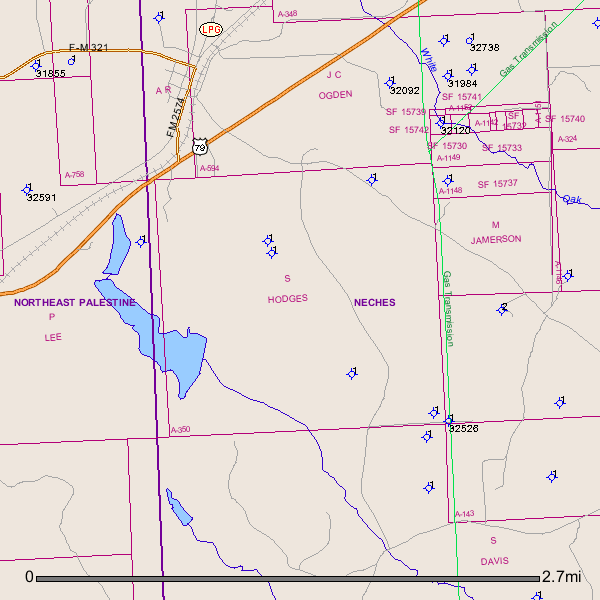
We have recent leases with Graem in surveys A350 and A430 and would be interested in any activities in these areas. As we only own inherited mineral rights, we don’t even know where the leases are located.
Bruce,
Your A-350 is just immediately south of the small town of Neches. Neches is located at the intersection of FM 321 and FM 2574. GIS Map of Anderson County A-350 and surrounding area:
Bruce,
I forgot to add, your minerals are located Northeast of the town of Palestine, Texas.
There is some clearing being done on Highway 155 about 8 miles north of Palestine on west side at Farm Road 4440. That road is about 300 feet north of FM 321. Anyone know anything about this?
Charles, wonder if you’ve seen or learned any more on that clearing you pointed out near Hwy 155? No new permits filed.
Has anyone been approached about leasing their property south of Palestine?
If you have, can you let me know what you were offered?
Good morning, So I just found out that after the passing of my father that myself and my 2 brothers receive his share of the mineral rights. My aunt leased her share for 1000.00. I’m aware that it’s a good idea to get a lawyer, but since my aunt leased her shares for that amount, does that mean I have to do the same? Thanks in advance any help I can get.
You are not obligated to lease your mineral interest even if your aunt or any other partial owner of the same minerals has done so.
But expect to be contacted by brokers trying to tie up your portion - just takes time for them to find the proper owners especially in cases of heirship.
Or you can contact the same people that leased your aunt.
But 100% agree it is best to get an O&G lawyer involved to work with you on any lease that you may consider. Tons of issues that need to be addressed to optimize your situation.
Sherry,
Welcome to Mineral Rights Forum and The Anderson County Group. Drilling activity is slowly showing up in Anderson County. What is the Abstract, Section and Block # of your minerals? I will pull it up on the GIS map and see if there is any activity in your area. Rockman is right, you don’t have to lease for the same amount or to the same operator/leasing agent.
Clint Liles