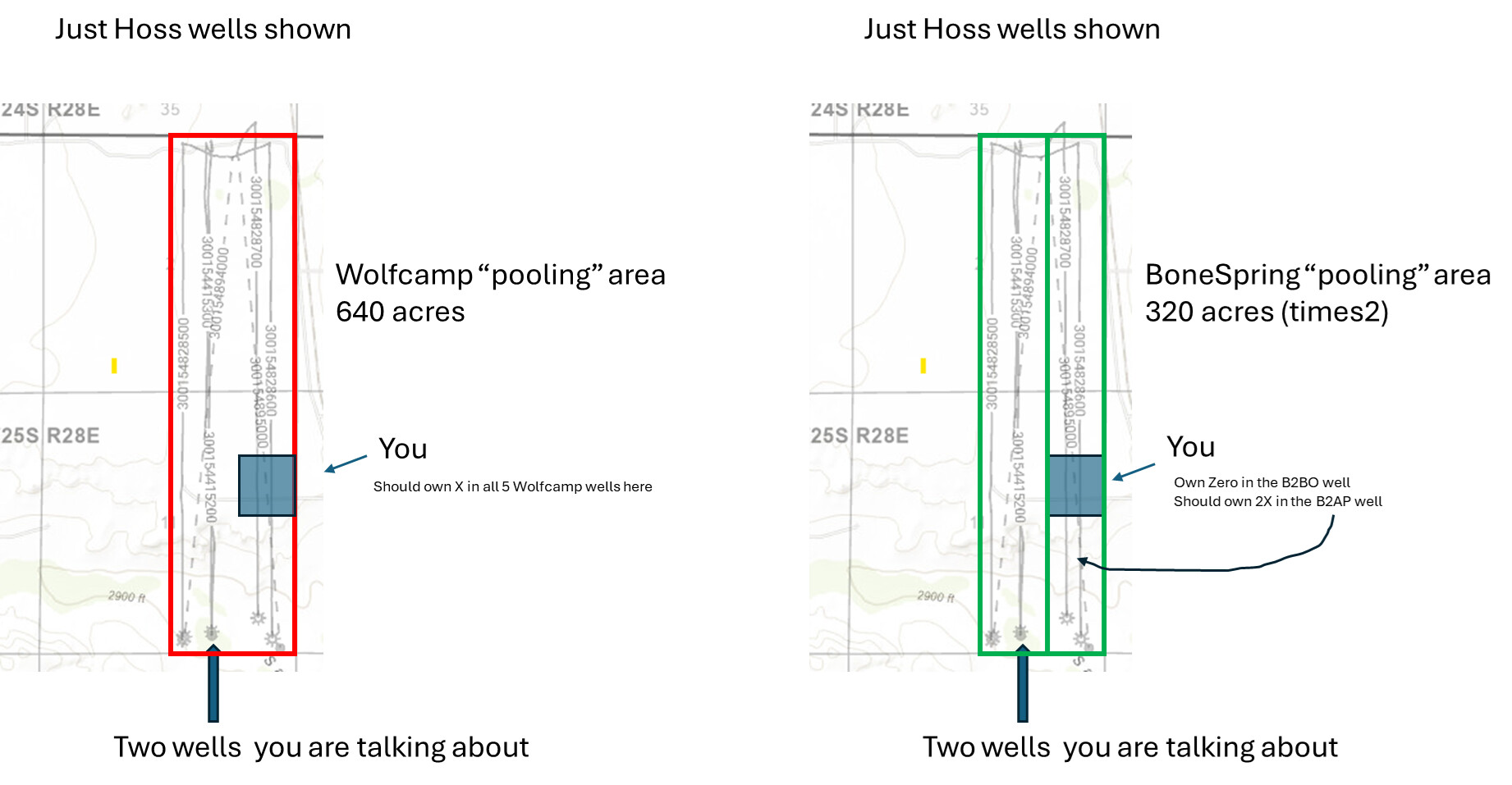
I own in the NE of the SE of 11 (so similar). The BoneSpring formation wells (B2B0) have a “pooled” area that is 1/4 mile wide, the Wolfcamp wells (W2BO) have a “pooled” area that is 1/2 mile wide.
This BSBO well is not in the 1/4 mile wide strip where your acreage is (same as me). The W2BO well is in the 1/2 mile wide strip where your acreage it. You end up at the same point if all of the wells are equal. Half the number of wells, twice the interest, or vice versa. Maybe the picture below helps.
I’m assuming you are getting paid on the other Hoss wells and it’s not just these 2?
What website do you use to find these “pooling” areas?
I am looking to find the pooling areas for the Baked Ziti wells in Section 29/Township 21S/Range 27E?
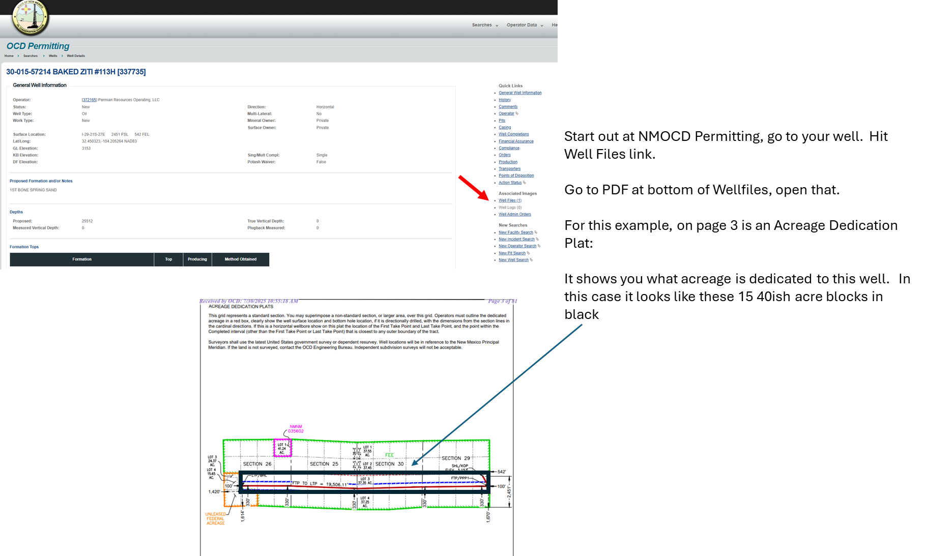
That’s API 3001556969. A different well than she referenced, but that IMO is the correct path. Go to the New Mexico Oil Conservation Division, look up your API number, look at the producing area. That’s how they will determine NRI in the well and how you see if your acreage is included.
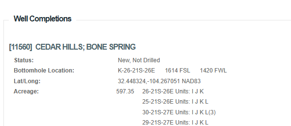
Kinda do what James was suggesting. Go to New Mexico Oil Conservation Division permitting, look up your well. You can then either go to the Wellfiles (PDF) and look for a picture of the participating/development area or you can just scroll down in the permitting part until you get to completions and that will have a description of the area. Something like this:
Red box vs blue box. On the one I saw the red box was the dedicated acres (the acres that get “pooled” to determine well NRI) and the smaller blue box was something like the well spacing (i.e., no other well in that zone can be drilled closer than 330’ from another well, so this well had a 660’ wide box running the length of the horizontal).
If you have any confusion about what acres are used to determine the well ownership, I would refer back to the legal description in the permit section of the NMOCD.
30-015-44153 HOSS 2 11 W2BO FEDERAL COM #001H is in the Wolfcamp. Wolfcamp top is at ~9585’
30-015-44152 HOSS 2 11 B2BO FEDERAL COM #002H is in the Bone Spring North. Bone Spring top is at ~6380’. Do you have a depth clause in your lease? They do have almost the same location on a plat, one just higher than the other. Ask them to clarify. Important as there are new permits by Mewbourne on that east side of 2/11
Clearly drawing pictures doesn’t help. One zone “pools” 320 acres, the other zone “pools” 640 acres. So she is in the Wolfcamp well that pools the E/2 of the Section and she is not in the BoneSpring well as her 40 acres is outside of the 320-acre pooling (the W2 of the E2). Nothing to do with depth ownership.
As per the other thread on this tract, the new permits have been drilled.
I appreciate all of the replies here…but I definitely didn’t post this a few days ago. I must have written this well over a year ago. I’m not sure why it suddenly posted now? Maybe it was pending posting? I don’t even remember why I asked this, but I will go over the info again and probably learn some new things. Thanks!