I am enjoying a little piece of the action in T25S R35E SEC 1 in Lea County. In looking at the well layout there appears to be (my guess) 8 or 10 wells sitting on top or at least very close to one another. There is production from all of the wells that I have received info on but why are they so close together? All of the wells include Federal in their names. But I would think the rate of extraction will not maximize the future production. Is this a “let’s party while we can” kind of a deal?
1 Like
They lay out the wells to allow for maximum drainage. What they look like on the surface is a projection of the subsurface. They may actually have a wine rack (or gun barrel) orientation at depth with some wells in a higher reservoir and some in a lower with the optimal spacing.
2 Likes
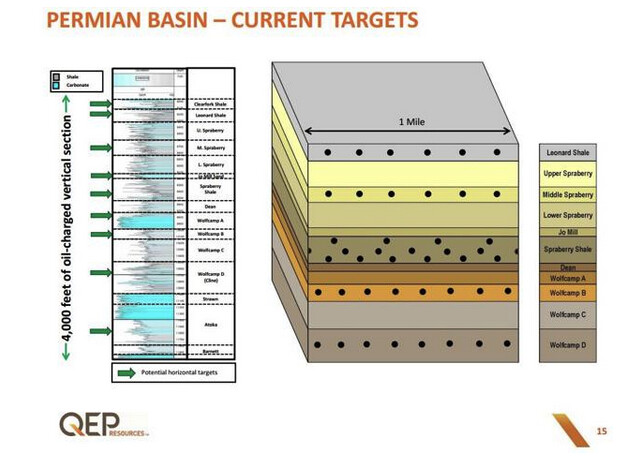
Subsurface picture above is for the Midland Basin, but Delaware Basin is the same general idea if slightly different formations. Leonard Shale = Avalon. Spraberry = Bone Spring. Wolfcamp = Wolfcamp. Yada yada yada.
First of all…if you are a royalty owner and not a working interest owner, you want the operator to strip mine the living hell out of your acreage. Cost and efficiency be darned. Drill a million wells and/or send down gnomes with buckets to get 100% of the oil to surface. Now that said, 10 wells spread out over a mile wide unit is not that many wells in Lea County. Yeah, on an infinite timeline a single well could drain a landing zone. But those 10 wells should all be pretty darn good wells. I would assume those are all in the upper Wolfcamp. It should say in the permit in the Wellfiles at the NMOCD what they were intending to target.
Either every operator in New Mexico has stopped sending directional surveys (the actual path of a drilled well) or else the NMOCD has stopped making them public, but pretty much all that is publicly available for a well is a straight line for anything post-2019. Assume all of those wells were drilled so that they are running North/South with roughly equal spacing and there are not the big gaps that the map below shows.
You’ll be fine. Your wells will decline very fast because that’s what happens with a giant hydraulic frac in nanodarcy rock.
2 Likes
Thanks to the responders – this is interesting prospective! In this case we will just enjoy our little ride!
This topic was automatically closed after 90 days. New replies are no longer allowed.