Does anyone know how royalties are divided under the Caribel unit API # 3510922497? I’m running into some confusion using different resources, some claim 640 acres, others claim it’s subject to spacing order 20212 which would spread it out over the entire WEHLU. Any help is appreciated.
Please add your section, township and range so the particular cases can be researched.
Section 29, Township 14N, Range 4W
It can depend upon the wording of the unitization agreement and whether a well is within the Hunton Lime or is in a different reservoir. The West Edmond Hunton Lime unit orders can be found at https://imaging.occ.ok.gov/imaging/OGUnitization.aspx. (Type in your section and you can pull up the three documents and save to your files.)
It also depends upon the timing of the well in question. You might have an old well that was pre-unit. It would have royalties based upon the original spacing orders from the time the well was drilled until the well joined the unit. Then the royalties would be calculated from the unit tract participation interest for the reservoirs outlined in the order.
Some sections are really complicated and have multiple unitzations at different reservoir levels, so the royalties are different by depth and by unit. All from a simple lease back in the 1920s.
All that being said for conventional vertical wells above.
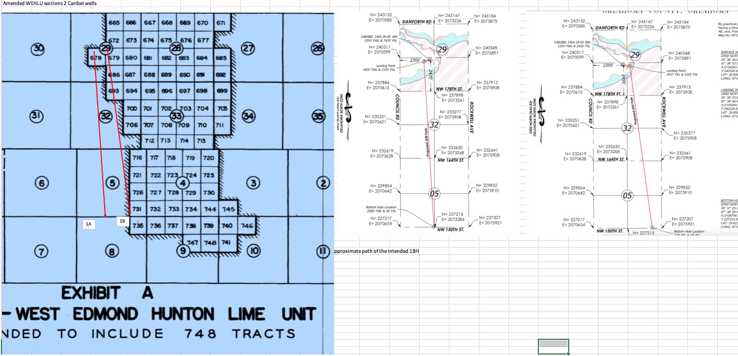
The Caribel 1404 29-05 1BH is a horizontal well. There is also a 2BH well. They are multiunit wells. They were spaced at 640 acres for each section-very common. However, since it is in the WEHLU and in the Hunton, it may end up with the same tract participation as the unit-or not… First sales were in April, so you will not see a Division Order for about five months after that. The splits between the sections and your portion will hopefully be spelled out on the order. You can contact the Division Order analyst at the operator to spell them out-but wait until the DO comes out and all the title work is done. You will get your portion of the wells according to what you own in Section 29, but not in section 32 or section 5. I looked up the well path and only a tiny portion of the well is in the WEHLU. So unless they amended the unit, most of the well is outside the unit. This could be a complicated one. I can see why there might be a question.
Maybe I’m looking at an old map but it appears that 29 and 32 of 14N-4W sit pretty much in the middle of the WEHLU…is there an updated map separate of spacing 20212?
I realize 20212 has been updated but I’ve only seen where it added tracts.
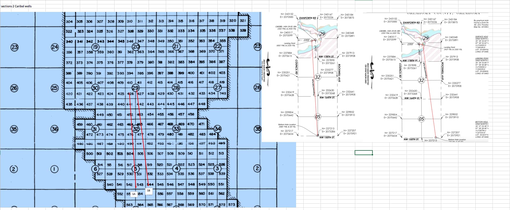
This is a quick screenshot of the amended WEHLU map that I found with the projected well paths drawn on top. 1A falls mostly outside the unit as seen here and 1B has a bit more in the unit. The decimals on each will be different.
That is huge!!! Where can I find that map?
Thanks so much!
https://imaging.occ.ok.gov/OG/Unitization/0058ECB7.pdf P. 32
The permit pictures are from the permits. Let me know if you need the link. They are sketches, so I took a picture and overlaid them on the unit map and drew an approximate line. The actual drill path can be found with the SURVEY on the well records site of the OCC.
Looking at the map closer it looks like the segment you’ve outlined is 5-12N-4W going in 29 & 32 of13N-4W. The Caribel goes from 5-13n-4w into 29 & 32 of 14N-4W.
Am I seeing that wrong?
You are right. I didn’t scroll up enough. Big field!
Here is the replacement. That would seem to indicate that the wells are entirely in the Hunton and entirely within the unit. Time will tell. Division orders should be out in a couple of months.
Yeah this is an odd one. I’ve contacted the CC and the TC and they are both stumped as well. I’ve placed a call in Revolution to try and get to the bottom of this.
Thanks so much for your help.
I have some sections where I have three-four different units at different horizon levels and it drives me nuts to calculate them. I have other units that have shallow production and then deeper horizontals that are completely independent and are easy to calculate and others that have unusual wording and I only get paid on the horizontals that actually cross my section, but at the Unit tract participation.
Are you referring to tracts in the WEHLU?
No, there will not be a DO in a few months. There is 1 deck for the entire unit, regardless of the Caribels. Have you been receiving revenue from the Unit?
Is OK county sec 28 14n 1w s2ne4 Included in this unit? (my optics can’t enlarge it enough to read. Thanks
No, a different area for me.
I suspect that you will get the same revenue decimal that you get now from WEHLU. Pull out your check statements and that is probably the decimal. You might not get a DO if the operator is calculating under the unit agreement. The wells will just show up on your statements. Keep an eye open for them. Some units have a Phase I payout for a certain number of years and then a Phase II payout. This field is so old, I would think it would be in Phase II by now.
I have not received anything.
New wells may not show up for about six months. You may get a big bump up that first month for them because they hold the royalties for the first few months, then will go back down to a monthly level again.
Ok, just wanted to be sure. I’m looking at this thing and any and everything I see filed and people I talk to are in agreement that this should be part of the WEHLU. The only thing I see debating that are newly filed tax commission status documentation.
Something has to give…
This topic was automatically closed after 90 days. New replies are no longer allowed.