Van Zandt County, Texas oil & gas discussion group. Share your experience regarding lease bonus, royalty rates, drilling activity, and oil & gas news.
Just received lease offer on 50 acres in Van Zandt County 20% $200/acre. Is that the going lease rate? Know anything about Riverwood Exploration? Property borders Henderson County.
Hey, Clint, or anyone, can you tell me where A-715 is in relation to A-885? TIA!
Ah, heck, I found the two places in relation to each other. Darn, my A-715 is between 15-20 miles ESE of A-885, with absolutely zero going on around it!
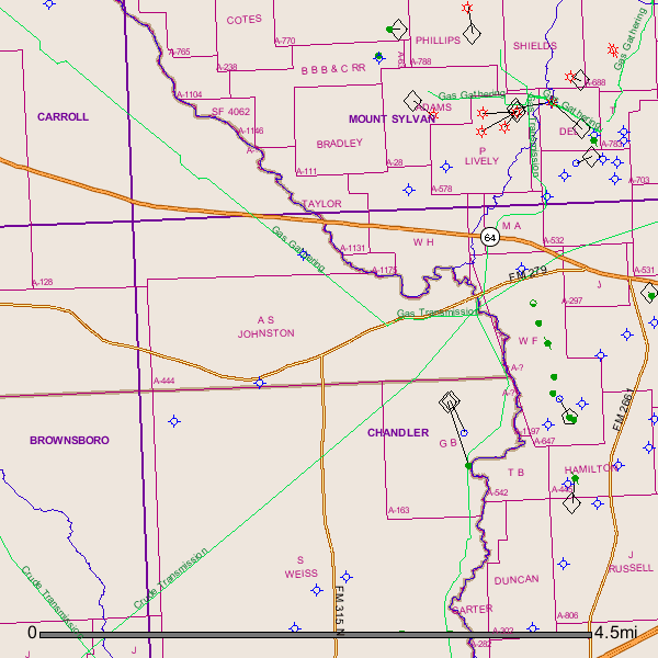
Clint, I am also looking for information on AS Johnston Survey, A-444 in Van Zandt County.
My grandfather owned minerals in Ben Wheeler. I would like to know if anyone knows of any drilling going on in this area. I have an old lease from a company dating back to 1991. Also anyone know what became of LP Browning Oil and Gas. He was my great uncle and would like to know if anyone knows any info.
Donna,
I just now saw your inquiry about A-444. Sorry about taking so long getting this info to you.
GIS Map of Van Zandt County A-444:
Clint Liles
Anyone,
There was a well drilled about 1 mile south of County Road 1507 between Grand Saline and Van, my family owns mineral rights on land that is 3 to 5 miles to the northwest off of County Road 1514. I was wondering how can I find out what the production rate is of the well that is already on production. Also is it common for a lease owner to not ask for lease payment and just for the royalties? One more thing, my dad had a landman come by his place a few years ago that was interested in the lease, said he was going to the courthouse and he would be back. The landman has never returned; what would be the reason for that?
I just checked - there have been no new permits to drill in this area between Van and Grand Saline over the past year. Just a “salt” well just outside of Grand Saline and a couple of wells NW of Van around Pruitt.
I cannot locate County Road 1514 - can you better pinpoint where this is?
Is this an older well? Or a new one?
As for your questions, it is rare in my experience for a person to lease for just a royalty payment and no bonus (“free lease”).
Several possible reasons the landman never returned - everything from he/his company changing mind on leasing to finding out via courthouse review that your family did not own the minerals that he originally believed that you did.
County Road 1514 dead ends into County Road 1507 which crosses Highway 110. South of that intersection, approximately 1 mile, there is a new well on the west side of Highway 110 that is in production. The well might be a little over a year old. I have the deeds to the mineral rights but I can’t get to them till next week because I am on a drilling location in West Texas. And thank you for your time in this.
Thanks for the detailed directions - put this just outside Van and south of the Pruitt Church at 1507 and 110.
The well you are referring to is the ETOCO LP #1 Brannon - right off the highway at CR 1506. IP of 179 BOPD. Latest report (May 2014) shows about 3600 BO for the month or 120 BOPD. Total production through May of 15660 BO with a pretty flat profile over first few months.
Should be able to find production on Tx RRC under ETOCO LP’s operator number. Looks like they are slow as to filing production reports.
I own mineral rights for 89.9 acres Abstract No. 502.
Does anyone know if any activity is happening on this land?
89.600 acres, Phillip Mason Survey, A-502 and described as being 89.6 acres of land, more or less, in Nacogdoches District, Van Zandt County, Texas known as part of Survey No. 222 on the waters of Dry Creek about 11 miles N 80 E from Canton, being a part of the land granted by the Government of Texas to Travis G. Brooks, assignee of Phillip Mason April 30, 1851 by letters Patent No. 597 Vol.8 by virtue of duplicate Certificate No. 593/692.
Abstract No. 502: Beginning at the stake for corner on the Cherokee Line as run by W. A. Ferris in 1841 at the South corner of Block No. 1 sold G. A. Clower from which a B.J. bears S 13 W 1.6 vrs and a B.J. bears S 78 W 4 vrs; Thence E at 1305 vrs. to J.P. Bradford’s NW corner a stake from which a B.J. bears N 21 W 3 vrs. and a P.O. bears W 21 vas; Thence South to Bradford’s West line at 415 vas. to his S.W. corner a P.O. bears S 55 W 5.6 vas, and a P.O. bears N 69 W 13.3 vas; Thence West 890 vrs. to the Cherokee line, corner, from which a P.O. bears S 14 E 16.2 vas. a P.O. bears N 37 1/2 E 4.4 vas; Thence North 45 W 587 1/2 vrs. to the place of beginning, containing 89.6 acres of land, more or less.
Hello Jan,
The last activity that I see that happened in A-502 was a dry hole drilled in 2006. I don’t see much anything happening in the surrounding area.
Link to drilling permit for well API 467-31087 drilled in 2006 (Dry Hole):
GIS Map of Van Zandt County A-502 and surrounding area:
Hi Clint,
Thank you for the information and the link to the permit. I was not contacted nor did I authorize the drilling of the dry hole. How was this permit issued without my knowledge?
The last drilling that I did authorize was in 1994 through Kenneth King. He contacted me directly and we went through the process together.
Jan,
If I was you I would contact the Texas Railroad Commission and find out who you need to contact about this violation.
This contact link is to the RR Commission:
drillingpermits-info@rrc.state.tx.us
Send them an email. They have always been very helpful and respond with my questions in a timely manner. Good luck.
Jan,
I notice the contact link won’t work for some reason. Try this one instead.
Help Desk Help.Desk@rrc.state.tx.us
Jan,
I noticed the contact link won’t work so try these contact links:
Clint, Clint, Clint, always taking care of all of us. Not sure what we’d do without you. Hope you are doing well.
As for the Matador dry hole, was it drilled on your 89 acre tract?
A-502 is a huge survey - as per DrillingInfo.com, Prestige (probable broker for Matador) took over 50 leases in this survey totaling over 7400 acres. There is one lease listed under your name (Jan Koehler).
It appears the well was drilled on the Rowan lease (over 1000 acres) - if this is the case, there would be no reason for operator to contact you as to their drilling plans.
Thank you Clint Liles and Rock Man for such good information. I am truly grateful.
However I did read in the permit section this clause:
“Notice Requirements. Per H.B 630, signed May 8, 2007, the operator is required to provide notice to the surface owner no later than the 15th business day after the Commission issues a permit to drill.”
Please refer to subchapter Q Sec. 91.751-91.755 of the Texas Natural Resources Code for applicability.
Since I am the “surface owner” and did not receive notice - per Clint’s advice, I sent an email to the Texas Railroad Commission. I will wait to see what happens.
Thank you again, Jan