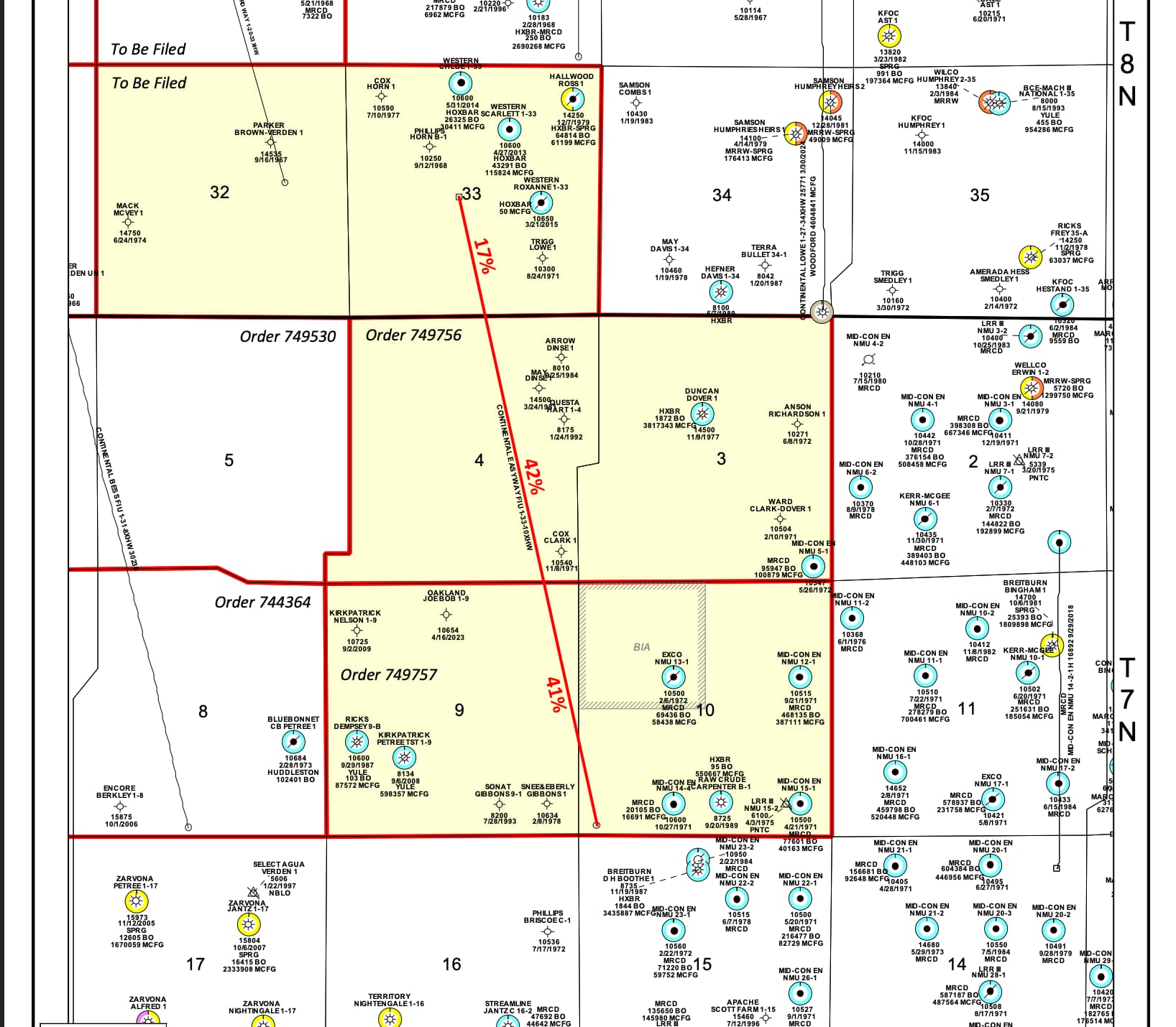
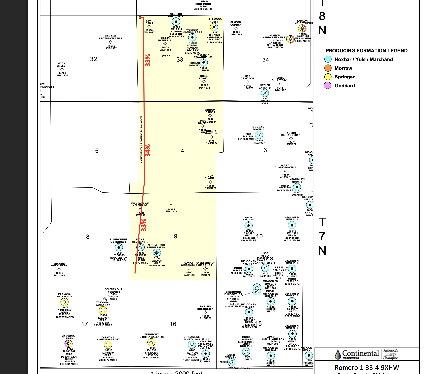
This is an unusual well, with 6 sections, offset, running NW to SE. Sections 32 and 33, Township 8 North, Range 8 West and Sections 3, 4, 9, 10, Township 7 North, Range 8 West. But it seems more unusual to me that all the usual corporation commission applications: spacing, increased density, Multiunit Horizontal Well application, and Pooling applications were all made on the same day (7-30-25). We received one letter from Continental in June with 3 offers, bonus money rising with percentage decreases. Like you would get with pooling order options. No contact from a landman. No real lease negotiations. Just an offer… take it or get pooled. Has anyone else seen this? Is this as unusual as it seems to me? Usually if we wait around a bit, then other landmen start bidding on the lease and we have more options, including using our own lease. It is looking like the oil company might be trying to make that process a bit more difficult or unlikely to happen. Any comments or advice?
How large is your interest relative to the spaced unit for that lateral?
It’s small. Sections 32 and 33 are only estimated to be 17% of the revenue and we have 20 acres in there.
Continental is planning on drilling multiple horizontal wells in this set of sections. They are angled NW-SE and N-S and crossing several larger spacings.
You should be getting the OCC mailings for the ones that you are involved with. Here is the map from the MU HZ case 2025-002520. There are at least four more.
Be mindful of the pooling order date. You only have 20 days in which to answer (by certified mail). Many of us would pick the highest royalty since these have a very good chance of being productive.
I own in Section 32 Township 8 North Range 8 West, and just signed a lease last month. My family has significant acres there too. What exactly do the filings mean?
“Just an offer… take it or get pooled” as you’ve surmised is the likely outcome. I enjoyed the times where we had open competitive lease plays in Oklahoma. Most of this proposed unit is obviously HBP so for Continental to negotiate your lease form, etc. would be a waste of time for them.
The filings are required to allow the drilling of a multi-section well. The various cases will determine the spacing of the intended reservoir (if it has not already been spaced), then the permission to drill a multi-section well- which sections and what percentage of the well in each section, the location exception from the middle of a section, then the permits can be filed. If your acreage is involved and your address and title information are correctly filed in the Grady county courhouse, then you will get the Oklahoma Corporation Commission filings for the wells that pertain to your acreage.
Based upon what CLR has already done nearby, I expect to see several wells lined up on in parallel across these sections.
We have been contacted by a Mr. Billy Reeves in Lawton about our Sections 9 & 10, Township 3N, Range 6W with some offers to lease for his “client” Lincoln Land (?) and he is not willing to disclose who the operator will be or the real end user. Are these the areas in the current discussion? Thank you.
Continental has already filed leases in 3-3N-6W. Operators in the area are Continental, Gulfport and Warwick-Jupiter.
Thank you Martha for the information ..
We have mineral rights/currently have Gulfport wells (Cheyenne) in Section 10, Township 3H. Does this multi-unit project land in this area? Just curious. Also, have mineral rights/Continental wells (Sinclair) in Section 15 - if there is any activity there too?
Thanks for any info!
Ryan
Please give your section, township and range when asking a question so that we don’t have to guess.
Apologies…
I believe we have mineral rights in Section 10, Township 4 North, Range 6 West (currently where Gulfport - Cheyenne Wells are, I believe). Also, Section 15, Township 4 North, Range 5 West (currently where Continental - Sinclair Wells are, I believe).
If your topic does not match the header on the current topic, it is better to start a new one. That is why the section township and range are so important. There are many wells called “Cheyenne” in OK and many, many wells called “Sinclair” Just helps keep the forum easier to use for everyone.
4N-6W is about 25 miles away from 8N-8W. 4N-5W is about 30 miles away. Here is a handy article to help you understand how the Section, Township and Ranges work in OK.
The header included Section 10. Hence my inquiry.
There is a section 10 in almost every township in OK, so you need to use the complete section, township and range to get the right one. Sort of like using the old Key Maps ….
This topic was automatically closed after 90 days. New replies are no longer allowed.