I am new to all of this and have a question. I hope someone can help…
I am confused about horizontal drilling. I am attaching 2 pictures: a diagram from an article that describes how through horizontal drilling, several shale layers can be drilled and oil/gas produced and a picture from the RRC website with sections that have multiple horizontal wells.
So, the article diagram suggests that several wells (total of 16 in a 640-acre section) can be placed on one section. Is that what I am seeing in the RRC picture snapshot I attached?
Has anyone ever heard of 16 horizontal wells on a section of land?
Yes, by drilling at different depths, you can put 16 wells in a section. Think of it as a wine rack type of configuration with staggered horizontal boreholes.
So how is that described or depicted on the RRC map? For example, would we see 16 green dots in a section on the RRC map?
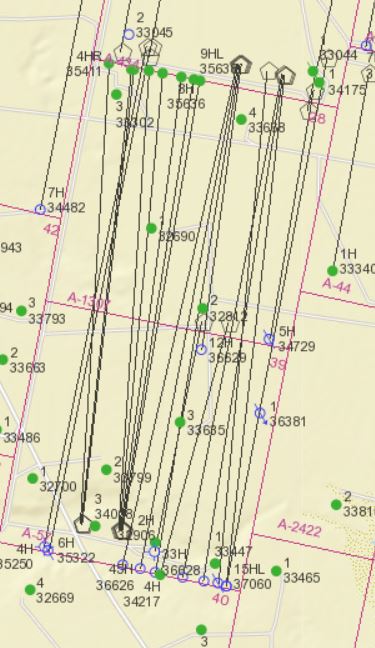
I find myself checking the RRC frequently to better understand what drilling companies are doing. Though the map is very helpful, it can be a little cryptic if you don’t know what you are looking at…
For an example, this is RRC’s map of Reeves County, Block 5, Section 28 & 39 H&GNRR Survey that shows at least 16 horizontal wells in each of those sections.
It’s common these days for horizontal wells to extend across two sections. Most of the wells on this map were drilled by Rosetta Resources, which is now Nobles. The ones with green dots at the end of the horizontal legs are currently producing, but others with open circles are permitted locations that may have been drilled but haven’t started reporting production yet. The map also shows a couple of wells that were dry holes.
The permits show these horizontal wells were completed in either the Wolfcamp or the Wolfbone formation, but Eagle Oil also drilled some vertical wells there in the Bone Springs formation (the green dots with no horizontal leg).
On RRC’s map, the horizontal legs of wells drilled from the same pad appear to extend from the drill site like the spokes of a wheel but actually they are drilled with a turn that allows the laterals to parallel each other. Here’s a plat showing the actual path of the horizontal legs for some of those same wells.
You probably noticed, but RRC’s mapping doesn’t show when horizontal wells are drilled to different depths. Everything appears as if it’s on the same level.
From the map, the only way I know to determine the depth of a lateral is to click “Identify,” select “wells,” click on the well you want to know about, then open its permit application to see the approved depth or field that was designated.