Thank you so much Don. I was coming up there from Texas but we are getting some freezing weather. I was afraid it would be gone by the time I get up there.
Great photos Don, Thank you! And also good info from Martha and Lee.
Any photos on new wells in Section 12, Township 5N, Range 5W, Grady County? Thank you very much!
There are infill wells in 5N-5W drilling in sections 10/3 Black Mesa and 9/4 Great Plains.
I see some leases filed at 22% and 25% in section 11 mostly in October of 2023.
Section 12-5N-5W is held by the England 1-12H well in the Woodford. 640 ac spacing Bogey 1-12X 1H in 1/12 Woodford 640 ac spacing
Sharon Rose 1-12 Simpson 80 ac stand up in the W2 NW4.
Did you pool before on 12? If you had an old lease, it may be held unless you have depth clauses.
Thank you, Martha. Checking on the old lease and the pooling. Appreciate your assistance!
Suzanne1663
Bogey 1-12X 1H and Bogey 2-12X 1H
Suzanne1663
England 1-12H
graceful99
Cactus rigs drilling the Black Mesa wells.. looking West
2 Likes
Great pictures, Don! Thank you so much for taking and posting them!
The last thing I got from Corporation Commission was a notice filed by Camino, Cause CD 2023-002089, (Order 739409) an order dismissing this cause. Relief sought was Multiunit Horizontal Well.
Not sure what this means. How many wells are being drilled? Thanks.
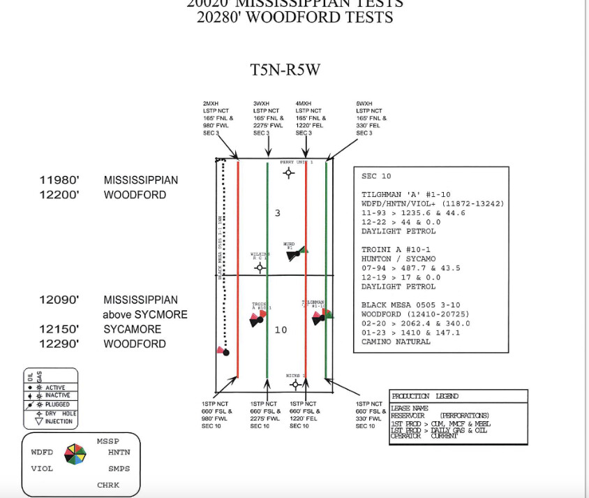
If the case is dismissed, then they are not going to drill the well related to that case. Looks like it was pertaining to the one 1220 From the East Line (FEL) the right hand red one. 4MXH
I looked this up before and the cases pertaining to the wells being drilled are to be heard in February sometime. Martha is correct that those cases dismissed are for well locations they don’t intend to use.
Thank you, Martha and Todd. The relief sought for Multiunit Horizontal Well Cause CD 2023-001737 and (001740, 001743, and 001745) have a notice of continuance on February 6, 2024.
It looks like they have the same number of wells but they have different Cause Numbers now? Does that sound right?
Yes. Different well bore path, but same sections.
If you read each case, you will find the distance measurements for each well from the east line or west line and match against the map above. Some operators put the name of the intended well in the measurements sentence which is handy. Some operators are not that helpful andjust make you read the map and try to figure it out.
The Corporation Commission recently approved Cause CD No. 2004-000212 from Camino. Looks like they were drilling a couple of Woodford wells and strayed into the Sycamore. As a result of this happening, Camino has received an OK for 2 new Sycamore wells.
Will there actually be additional Sycamore drilling or does this filing cover the few hundred feet of prior intrusion into the Sycamore?
(Patience has never been one of my strong suits!)
1 Like
Case 2024-000212 is an increased density case for the Sycamore zone which is above the Woodford. The deeper Woodford wells have to go through the Sycamore to get to the deeper zone. The Sycamore is a reservoir in its own right. Camino already knew the Sycamore was there from older vertical wells. (Hubbard, Wilkins A & B, Gordon). It is sometimes hard to keep a horizontal within the planned zone, so looks like the 2WXH well designed for the Woodford, strayed upward for a while and further confirmed the pay in the Sycamore. The two new wells are planned for the shallower depth.
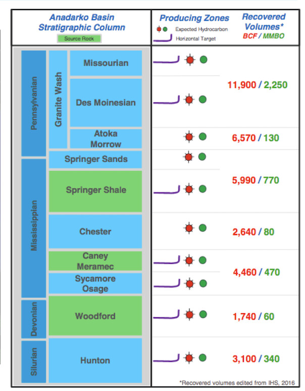
This stratigraphic column from IHS shows the relationship.
Sec 6.3 from the case requests two more increased density wells for the Sycamore. Sec 7.2 explains that the Great Plains 0505 4-9 1MH well has already been completed in the Sycamore (The M stands for Mississippian-Sycamore is in the Lower Mississippian). Sec 7.3 explains about the other wells in the Sycamore.
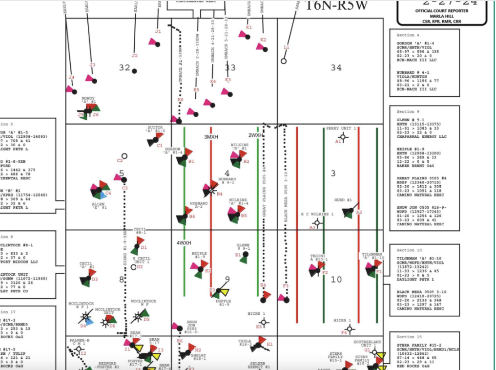
The map from the Exhibits shows the two new wells.
Congratulations on additional wells.
1 Like
Am I correct that the drilling debris from the Sycamore contained enough recoverable hydrocarbons that there may be 2 additional wells drilled in addition to 2WXH and 4WXH?
Thank you, Mr. Baker and Mr. Bray for your time and consideration guiding me through this experience. I could return the favor showing you the way to some manatees and red fish down here.
2 Likes
When wells are drilled, cuttings come up the borehole and into the mud pits. Mudloggers and/or geologists monitor the cuttings for hydrocarbons using various testing methods. The well was probably also electrically monitored using various borehole methods which also look for hydrocarbons. Not sure which method or both that they used in this case.
2WXH and 4WHX are Woodford wells-note the W in the name. 4WXH spud 12/15/23. 2WXH spud 12/17/23.
Great Plains 0505 4-9 1MH has already been drilled in the Sycamore-note the M in the name for Mississippian. There is already a permit for 3MXH-see the red well in the display above. It was spud 12/16/23.
If you go back through the Increased Density orders, you will find Case 2023-001982 which gave permission for one extra Sycamore well-probably 3MXH. I think this new case is just asking for the another additional Sycamore well. My guess is that it might be named 5MXH, but we will see.
2 Likes
I have spent decades working with very fine rig guys! You know your stuff and had the dangerous part of the job. I respect what you do.
2 Likes
Mewbourne Oil Co rather.
1 Like