I have 96 acres in Midland County, Texas (I don’t own the minerals). Both Endeavor and Momentum have wells and pipelines and whatever operations going on the land. I have two issues. My insurance agent suggests that we get a copy of each company’s certificate of insurance, and that we are added as additional insured if at all possible. I’d also like to get the surface agreements that were signed by a previous owner, I believe in 2006.
I’ve contacted both companies by email and they acknowledged my email a few days after I sent it, which was 3 or 4 weeks ago. I’ve sent some reminder emails, but haven’t heard back.
My initial impression was that they were going to be helpful, but now they seem to be ignoring me. Are there any ways to get some action out of them on these topics? Are these unreasonable requests?
If you think surface agreements were signed by a previous landowner, and they were recorded, you should be able to find and copy them from the Midland County deed records on sites like www.TexasFile.com or www.CourtHouseDirect.com. If you don’t know the names of the previous landowners you may first have to research the deed records for those.
Do you know if your acreage is part of a producing unit? If Endeavor, or an earlier operator Endeavor took over from, had a lease on that mineral interest when the facilities were built they may not have signed any agreements with prior surface owners.
The things you’ve request may not be unreasonable from a surface owners viewpoint, but as long as that mineral interest is under lease/HBP there probably isn’t anything that would require the operator to provide the surface owner documents or information. If your acreage wasn’t part of a unit or the unit is no longer producing, and there are no recorded easements or surface agreements you may have a stronger argument.
Thanks for the suggestion of looking at the recorded documents. I found one with Fasken that now belongs to Momentum. I wasn’t able to find anything with Endeavor, but I may not have looked in the right place, yet.
The pump jacks are running so, I guess that means it is a producing unit.
If you want to post the legal description for your 96 acres, like Block and Section or Abstract number, somebody should be able to pin down the unit you are in.
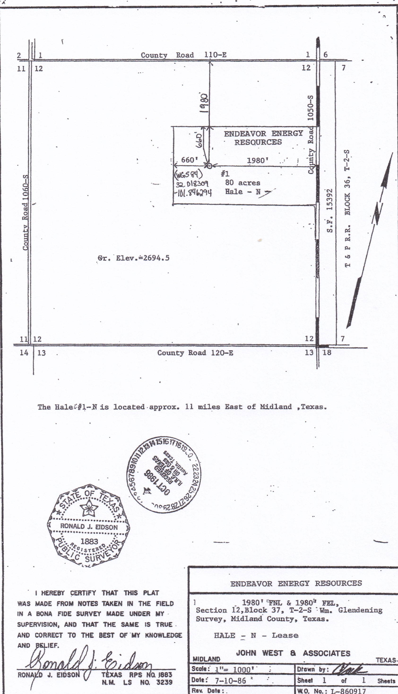
The north 1/2 of the property is the F.E. Glendening Survey, A-1308. North 1/2 of Section 12, Block 37, T-2-S
The other portion is the WM. Glendening Survey, A-1032, South 1/2 of Section 12, Block 37, T-2-S.
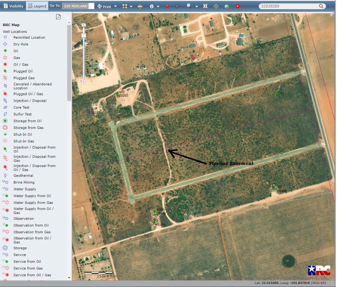
Looking at the RRC GIS site I think, but it’s a little hard to tell for sure, that the well near the northwestern property corner is API number 32901486. The other well near the southwest property corner is API 32901491. Not sure if that info helps or not.
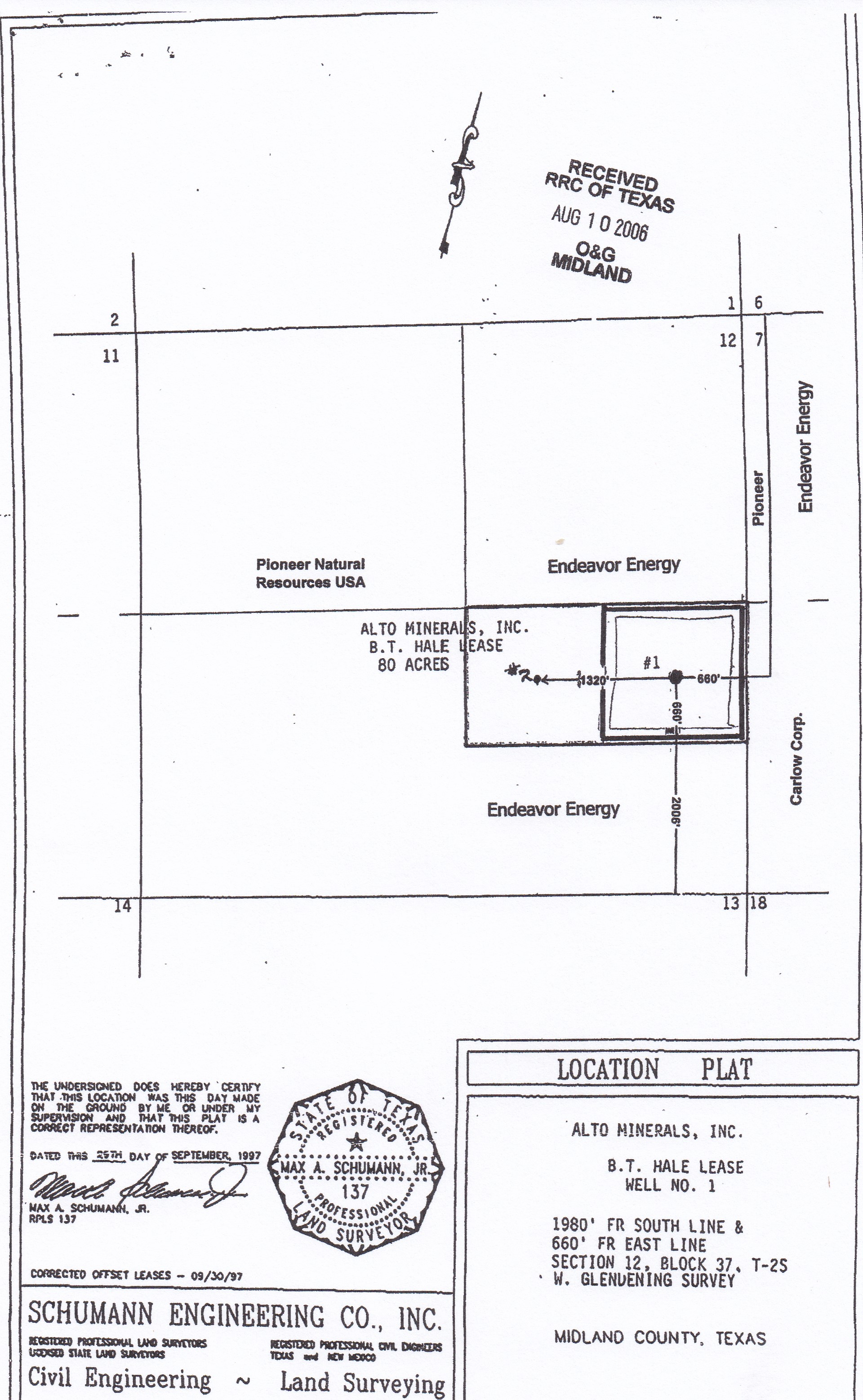
Attaching a couple of unit plats that appear to cover the area you are talking about.
It looks like the well you mentioned with API # ending in 1486 is what is shown as the #2 well on the plat for the B.T. Hale Lease. Momentum is shown as the current operator but they haven’t reported any production from that well since April, 2020.
The other well with the API ending in 1491 is operated by Endeavor and appears to still be producing but it looks like it may be in a separate unit that is south of the area you described.
Check your legal description. If the two pieces that make up your 96 acres are adjoining looks like it might be the North 1/2 of A-1302 and South 1/2 of 1308 since 1308 is north of 1302. There are several other active wells in those two leases but some may have been converted to injection wells.
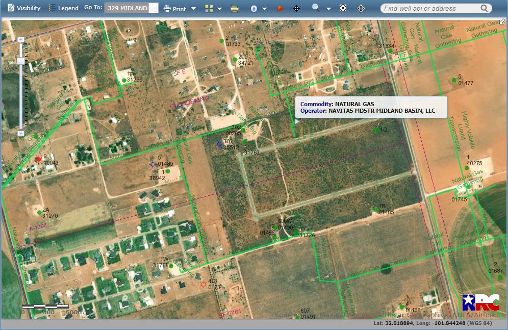
I appreciate all your help. It looks like the legal descriptions I had were correct, but not the API numbers I gave. I figure out how to turn on the satellite imagery on the GIS and figure out the right API numbers.
32935512 Momentum SWD
32931763 Endeavor Oil Well
32901490 Momentum Oil Well
32901486 Endeavor Oil Well
32901485 Endeavor Oil Well
Momentum responded today saying they don’t have any surface agreements in their records. They also won’t do anything on the insurance.
On that RRC aerial if you’ll go to Visibility at the left side of the page and click pipelines you can overlay the lines that cross you. Then use the pull down menu under the “i” in the circle in the top tool bar and click to see the names of pipelines or wells and access details on them.
They came from RRC’s online records. If you want to find them, on RRC’s map click one of the wells in that section and on page of well information that pops up go to the bottom and click “Oil & Gas Image Records”. On the page that opens, at the left side click “Actions” and then select “View Documents”.