Hello, Z. Mann here, way down in Nashville, TN. I believe my Continental lease expires around the first of the year - (Stephens County Section 7, 1N, 6W) - and I am wondering if anyone knows anything about interest from anyone leasing in the area?
I meant Jo Ann wells numbers 2 and 3.
John, horizontal wells usually include all royalty owners in the section, some are even multi-section wells. If a well is limited to certain royalty owners in a smaller drilling unit it is most likely a vertical well. Picture a vertical well producing from an underground lake and a horizontal well from a river.
Those metaphors present a vivid understanding - Michael. Thanks.
However, something must have changed since 1981-85. Because I have minerals in two sections in Grady County and minerals in one Stephens County.
Eva Graham S20-3N-7W (Grady); and, S13-2N-7W Stephens;
The Anadarko Basin has historically been referenced as depth hole country - meaning below 15,000 ft.
And when a hole was drilled at or beyond that depth, it was one per 640 acres and all mineral owners were participating and stood to gain from a single hole.
As in the case of Eva Graham.
When the Rush Springs well came in at 10,000,000+ cubic feet of gas a day they had to throttle it down production wise.
That’s when I leased S21-3N-8W: $2500.00 an acre and 1/5 royalty.
Expecting a deep hole to be drilled but nothing happened.
And there’s the Woolover Trust in Stephens, a deep hole well which came up dry.
Yet in other quarters of Section 13 oil has been found.
Eva Graham was looking pretty good at 1,000,000 cubic feet a day still yet it was declared a dry hole.
Your metaphor analogy is easy to understand. But my thinking was operating under a different understanding.
So what has changed?
Thanks John
Went back down to where the Jo Ann numbers 1 and 2 were Spud but nothing else has been done yet. Guess they could possibly be waiting for a rig to get loose???
John are you trying to say all the oil in Anadarko Basin is below 15,000 ft? That is far from being correct.
Regardless, the well payments are distributed to those in the spacing unit. The spacing unit is determined by the OCC based on testimony of the geological make of the formation being harvested.
The first link below describes it. The next two have additional info. Additionally, just because something is spaced at 640 acres, does not mean it covers the entire section. I recently had a well that the 640 acre spacing covered the East 1/2 of one section and the West 1/2 of the adjacent section. So a portion of our property was force pooled on the well, and the remainder is not covered by the production of the well.
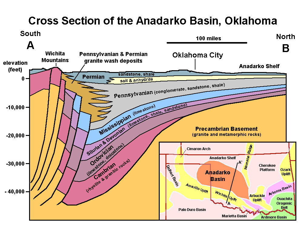
At the bottom is a cross section of the Anadarko Basin. There are many formations in each one of those systems. Any one of those could hold hydrocarbons.
http://www.occ.state.ok.us/ap/spacing.html
No Rick I was not trying to say that.
My thinking heretofore had based on what I had been told and I had no way of knowing anything else.
Therefore I reasonably thought what I thought based on what I knew. And I began to reason something must be wrong. I was confounded.
One hold Below 15000 ft for GAS
and everyone was paid.
Yet other drilling was taking place.
And Section 21 had been leased at a high price.
Now I see from differently but before I was able to based on what I had been told and my consequent understanding.
Michael had mentioned Vertical and Horizontal drilling. I thought Horizontal drilling was relatively A NEW IDEA.
I have a New Pic and understanding now. And do not feel about it like I used to. Tks John
In the day and practice of Drilling One (1) Deep Hole Well below 15,000 ft within a 640 acres, same section, every Mineral Owner in that Section stood to benefit if the well became A Producing Well.
I am confused because now they drill in Particular Quarters of A Section and there are Limited Mineral Owners.
The Deep Hole Well below 15000 ft goes down past the shallower wells deep.
How can a deep hole well miss what shallow wells find?
Tks John
Horizontal drilling is 30+ years old and started showing up in a decent quantity around here about 25 years ago. Chevron and Chesapeake drilled several in Stephens County in the mid 90s. I think we have a small interest in about 5 horizontal wells that were drilled in 95-97 in Stephens.
Everything is relative, so I guess it depends on your definition of relatively new idea. Even though commercial drilling is 120+ years old in Oklahoma, 25+ years is a pretty long time.
Geologist here:
The spacing for vertical wells is usually based upon the depth of the horizon and product to be produced with oil having smaller spacings and gas having larger. In general, they would space oil at 40-80 acres and gas at 160 for shallow horizons (perhaps~6000’) and larger spacing at deeper horizons with the max being 640 for gas. Oil has a larger molecule and gas has smaller molecules so can travel through smaller porosity and permeability. All dependent upon pressure. Traditional reservoirs of sands would have geologic shapes based upon their depositional system. Quite often in the shape of rivers, sand bars, delta fans, etc. Limestones are quite different in shape due to their depositional environment-round atolls to long reefs, etc. The spacing unit is designed for one well to effectively drain those acres. That effectiveness is based upon pressure, molecule size, porosity, permeability, etc. As time goes on, they may discover that they need more than one well, so down-spacing and increased density can be approved.
Horizontal wells have more recently been drilled in the shale units which are the original source rocks and can cover counties to states in size. Think lakes or seas (sorry Mike, have to switch your comment from before to the other way around). These have been traditionally spaced at 640 acres which is typically a section, but like Rick, I have seen some split 320/320 across a section boundary. The Shale Act covers these. Some are now being spaced at 1280 for a unit. Just last year, the legislature passed a law for conventional reservoirs to allow multiunit wells. The shapes for those could get interesting due to the depositional patterns of sands and limestones. That remains to be seen. This is one reason I leave my Pugh clause in my lease to be 80 acres for oil and 160 for gas unless changed by the OCC. We could see some really odd shapes coming.
You will often see different spacings at different depths for different reservoirs within the same section. Happens all the time. Another good reason to have a depth clause in your lease.
Jen, Merry Christmas to you as well. Looks like the Grinches at CR are in the spirit too, just got my direct deposit email.
That’s ok Martha. I was just trying to give an illustration of how you might picture horizontal vs vertical drilling.
When we quit business in 1991 of Lindsey Well Service, Inc. after 35 years my hubby said some were just beginning to do some horizontal drilling around this area. Even though we had drilling and work over rigs at the time he said he didn’t get much experience with the horizontal stuff. I believe he said they had it in some other parts of the country before that.
HOPE EVERYONE HAD A WONDERFUL CHRISTMAS!
j temm… this is just a stab in the dark because I don’t know anything really about it but if some fracking is going on around your wells they might either have shut them in while they fracked because sometimes it can kill the current well around where the fracking is being done… or… maybe they didn’t shut them in when fracking was done and it did kill some of the production. You should be able to look at your stubs in the past and the ones now to see if production is down (actually I can hardly read them but those in the know can tell all about the production from the stubs). Our Newfield checks in Section 16 are up this month and the Continental check in Section 29 (both in 2N 4W) was down but the Continental well is mainly a gas well and the Newfield wells are mainly condensate which pays the same as oil. I have seen where oil prices have been rising and the gas prices going down some since they reached $3.00 a few months ago. So it might make a difference what your wells are producing. Hope this rambling hasn’t confused you more. Best Wishes!
Our production checks from Continental have dropped significantly the past 3 months. We are in Sections 5, 6, 7, and 8 in 2N Township and 4W Range. The folks at Continental were no help when I called. Is there a reason production has dropped over 60% in a few months? What can I check? Thanks, Joe
Looking to sell 20 NMA in Stephens, any buyers around?
Section, Township and Range please.
Got a lease expiring in 23-2N-6W in March.
Any ideas on bonus and terms being offered in this area?
Tim Step, please give me the Section, Township and Range of the parcel you are looking to sell.
Anyone aware of any leasing activity in section 2 1N-7W? If so, amount received per NMA? Thanks.