Stephens County mineral owners- Let’s use this “topic” as a substitute for the old format we relied on. We can post general comments here. If this site survives, perhaps management will listen to the users instead of the programmer and restore the old format we could understand.
1 Like
Any lease or buy activity near 23-1N-8W?
Sorry, no activity. Last permits in the area were for section 9 in June 2018.
1 Like
This isn’t actually a reply; it’s just easier to reply than to rummage around looking for the Post prompt. I was looking for info on a new well in Sections 23 & 14, Township 1 North Range 5 West, which supposedly was drilled several months ago, put in “imaging.occeweb.com/ogwellreccords.aspx” but got a message “site not found” or some such. I got it from a post by someone on the forum fairly recently, but deleted it. Can you please let me know what I should be using? I’d like to know if the well actually was drilled and if so, how it turned out. Thanks.
Renea No. 1-23-14XH Well; TD 22,788’; Gas; Woodford; 1216 MCFPD, 80 BOPD
Does this help? Drilled by Continental. You should be receiving revenue from this if you have minerals in either Section 14 or 23.
Todd, the Renea came in in 2017, & I have been getting paid for what I have in Section 23. Then this past August I got a letter from Pepper firm saying “Applicant has drilled a multiunit horizontal well in the Shale Reservoir.”… etc. This one also Continental, on Sections 23 and 14, Township 2 North Range 5 West. So that’s the one I’m interested in, in case you see anything about it. Thanks. Kathy McCaughna
Test. You need the http:// in the front of it.
You were close. Look up all the wells for 23-1N-5W in Sec 26. They have their surface locations there. Use 2601N05W I the legal location box.
Defeated again. When I put in http://imaging etc etc I get a message saying “server error in ‘/’ application.” So I finally gave up and just entered http://imaging.occeweb.com and got that site. But the only thing on the form I know to put in is the legal location you gave me. I looked up the date on the Pepper letter and it’s Aug. 7, so assuming they had drilled then, the end of January would be six months. So I’ll just wait and see if a new well shows up next month.
What document are you referring to as the Pepper letter? There are only two wells in section 23-1N-5W. Love 26-23 drilled in 2014 and Renea 1-23-14XH drilled in 2017. Both have a surface location in 26. There was a new permit to recomplete the Renea in September of 2018, but not for a new well. There is no further information if they actually did recomplete. I do not see any bumps in production, but the last date I see is September 2018.
Martha, thanks for the translation. Over the years I’ve come to think of letters from David Pepper of Hartzog Conger Cason & Neville as “Pepper Letters,” which although mostly incomprehensible, to me at least, usually bring news of some new well. The letter of Aug. 18 stated Relief Sought: Multiunit horizontal well in 23 & 24, 1N 5W. It concludes with request relief granted. So apparently somewhere in the body of the letter is something in legalese about “recompleting” the existing Reana. Well, I’m disappointed there isn’t going to be a third well there, but at least now I know that “well approved” doesn’t always mean a new one.
What was the case number at the top of that letter? I can read it and see what it said. From what I found last night, there wasn’t a new well yet, but that case docket may be enlightening.
Below Cause CD No. is 201604643. Under Order No. is 680915.
Ah, that is what I thought. This was the almost final order for the Renea well. There is actually one from September after that with some corrections. They had an emergency order, then an interim order, then a final order and then a correction to the final order with the splits for the perforation percents so the Division Orders can go out.
http://imaging.occeweb.com/imaging/OAP.aspx
If you go to the OCC OAP site and look up Cause 201604643, you will see about 20 lines of information on the order. Put them in date order and you can follow everything that happens on the case.
You solved the mystery, Martha. Congrats!
Mr. Baker, I have mineral interest in 23-1N-8W. Do you know if wells (vertical or horizontal) are located on this property? Thank you so much. Just inherited and trying to figure out if any current activity.
You can look up any wells on the OCC well records site. Use 2301N08W in the legal location box.
http://imaging.occeweb.com/imaging/OGWellRecords.aspx
Production can be found on the OK Tax site. Again, use leading zero where needed. Appears that the Cash #1 and the Hallett Unit wells in the SW4 are still active. If your acreage is in their spacing unit, then you may have royalties. If not, then none.
https://otcportal.tax.ok.gov/gpx/gp_displayPublicPUNListSearchDownload.php
Thanks, M_barnes, for your contributions to this forum. I sell surface land in Prescott, Arizona, but I grew up in Duncan and my great-grandfather Frensley got around 1,000 acres of land in Section 24 and 25, Township 1 South, Range 5 West, just west of Velma. He got the land because he owned a general store in Velma and had given the cotton farmers credit.
When the Dust Bowl happened, he got a lot of land by forgiving the debts when the farmers left for California.
Some of the leases were originally with Skelly Oil Company beginning in the 1940s. These were taken over by Texaco, which then merged with Chevron. Our royalty checks came from Texaco or Chevron for nearly 20 years. Stephens and Johnson now operates the wells and pays royalties to our family. As far as I know, the entire area was leased at 1/8 royalty. I don’t think I have ever seen any of the old leases. I doubt there are depth clauses on any of them.
Going to Stephens County to do research is not something I can do easily. Is there someone there who would be available to do some research? I have probate records for most of the properties, but there are a few that I get offers to buy or lease that I do not have history on.
I own a subscription to Mapright.com and can make really great maps from it. It can track the surface owners but not the mineral rights owners. Here is an example.
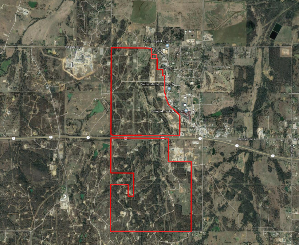
I can draw on the maps in this application and I have thought about drawing some of the horizontal wells.
2 Likes
Mr. Mosier,
I am not a Landman by trade but do know how to do the research on Mineral owners. A very kind Landman taught me what to look for and where to look for it while doing research for my family. His kindness has helped me learn so very much I would like to “pay it forward” if I am able. If you would like to message me I will come back to this thread and check every few days. If not for Martha Barnes being so free with her knowledge I would never even have known to even go to a County Courthouse and lost all those valuable acres of Minerals. This site is the best resource for beginners to learn.
2 Likes
If you have omitted properties from the Oklahoma probate, you may be able to re-open the cases to add these properties. If the probate was done elsewhere, you may need an ancillary or summary probate to clear up the title.
Casillas Petroleum Drilling letter is out for Section 9-Township 1 South-Range 4 West. $3,500 1/8th; $2,500 3/16ths; $500 1/4th;