Continental Resources
Helen 4-5H, NW NW 17-154N-96W
Williams County, North Dakota
Lot 3, 05-154-96W, API 33-105-06337
Spacing Unit: Sections 5, 8, 17 and 20
These four sections are all stacked vehicle. Does that mean the well will be drilled for about 4 miles through these 4 sections?
Thanks for any information.
That’s a good question, and would make some sense as a way to do things. But… I doubt it. I’d guess the Helens are just going to be 5 and 8 like the parent well. They also permitted wells in Section 17 (i.e., in the middle of the 4 sections) which are probably 2-mile wells.
Why do it this way? I don’t know for sure, but a lot of times it’s just so you can get away with pad locations that would otherwise be off the unit (i.e., this way you can drill 5/8 from a pad in 17, for example, without getting held hostage by surface owner as it is now “on unit”).
As far as I can tell, there is only one four-mile well in North Dakota, by Hess. And even that I’m not really sure of. Around the lake seems like a good place for it though.
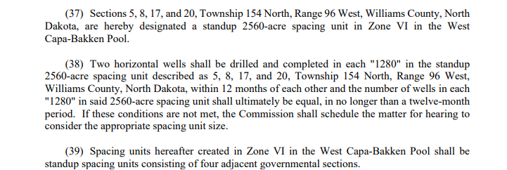
I could be wrong. Here was the West Capa order which implies it’s really two 1280s.