Looking at the Wilson 0817 in 8-8N-4W they have 640 acre spacing with 50% in Section 8 and 50% in Section 17. Does that mean you get paid regardless of where you own in either section (albeit at a diluted percentage)? Or is there a specific delineation in the spacing ruling where only people who own in the western half of either section get royalties?
"Where: within the same section will not matter. The 50%-50% split between the two sections is “proposed” and there will be a final number established once the survey of the wellbore is complete. It will be based on the perforated lengths of the laterals in each section. But each owner will get the same amount per net mineral acre factored with their royalty interest in their lease as the others in that same section.
In severe cases with a problem with the well bore you might see Section 8 having 4000’ of lateral and Section 17 having 1000’ resulting in an 80%-20% split. So from east to west for a full mile and owners on the far south end of Section 8 will not see a difference, but cross the line into Section 17 to the south would make a big difference compared to their northern neighbors.
2 Likes
Thanks for that information. In their 3Q 2017 report, EOG noted that wells in this area should produce 800,000 BOE net of royalty. If the average royalty was 3/16, that would be a 984,000 gross BOE well.
Average will likely be closer to 22-25% once you tack on the numbers.
Also be careful about using BOE numbers. If it is 100% gas well, a BOE is worth about $17 if natural gas is selling for $3 vs $70ish for a BOE of 100% crude. As a mineral owner, I care more about the dollars the well produces than the amount of energy.
1 Like
@Rick_Howell is speaking some gospel with this…
1 Like
Excellent point on BOE. EOG is seeing 70% oil in the Woodford wells. I was just excited to see a total production estimate because my decline curve analysis is a little rusty.
As far as multi-unit drilling programs go, have you seen any that go multiple directions like north and south when several wells are involved? I’m looking at the “Candi 231411 1H” in McClain 23 8N 4W. They seem to be running only one direction from the pad with other parallel, closely spaced horizontals that have the 1H, 2H, etc. labels.
I have but it is not that common. From what I understand, they prefer for the heel (the start of the lateral near the vertical bore) of the well’s lateral to be slightly lower than the toe (far end). There are some methods to overcome not being able to do this. I’ve also seen a few articles discussing a rise and fall along the lateral looking similar to a slight roller coaster as another method to increase recovery.
The wells are going north and south instead of east and west because of the formation grain structure. Think about trying to break a board with a grain vs against the grain. The bore direction makes a difference in how it responds to fracturing.
Here is one I’m aware of in Hughes County where there is a pad with laterals going both directions. I’ve seen a few others but have been following these so it was easy to find.
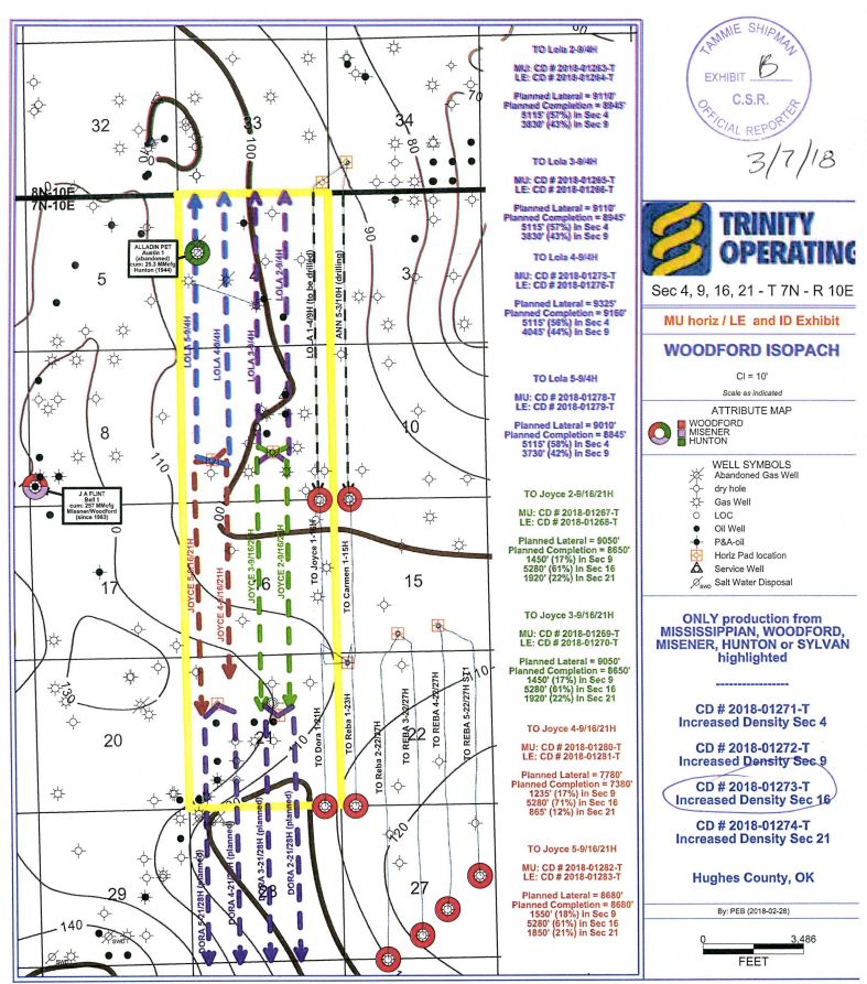
This link may work better http://imaging.occeweb.com/AP/CaseFiles/occ30076215.pdf
Notice the existing Lola 1 with a surface location of 34 yet the lateral is going to 4 and 9. It is common to see it set up like the ANN 5 with a surface location of 34 with the lateral going to 3 and 10. But the Lola 1 has a surface offset and is going from 34 into 33 before arriving in 4 and 9.
1 Like
Rick, Thank you for the best post I’ve ever seen on this forum. Just located the “Sturgell 0805 and Sturgell 1720” in McClain 17-7N-4W which runs 4 south and 1 north (for now) from a common pad. This is good news for my friends in Section 5. Thanks again.
1 Like
Hello Nigel, Have you heard anything as to the production volume of the Sturgell 1720? Inquiring minds? Thanks, Joe
Joe, I don’t see where they have issued a Production Unit Number on that well yet. They would need a PUN to sell oil.