Reeves County – There are 2 similar lease names State CVX 22 and the State CVX Unit A1922 that have the same API#, same well number, same operator – are these one and the same well? Also there is State CVX 22 that I can see 2 different API #’s and 2 different well numbers and lease #’s – are these one and the same well? I appreciate anyone’s help.
Not sure where or why you are seeing duplicates. RRC well bore query shows only one location, one API and one lease for each.
State CVX22 API 42-389-35111, RRC Lease 48031, Dist 08
State CVX Unit A1922 API 42-389-35359, RRC Lease 48118, Dist 08
History of Unit A1922 is more complicated as it was recompleted as a salt water disposal well.
Link for wellbore query: http://webapps2.rrc.state.tx.us/EWA/wellboreQueryAction.do
Screenshot of RRC map locations:
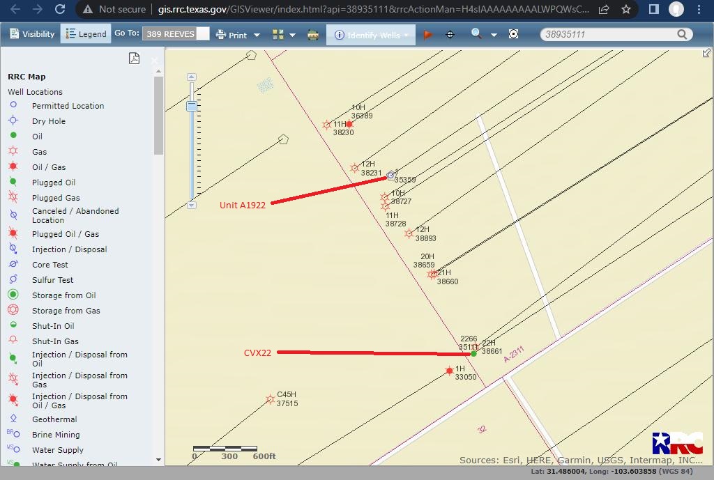
Hope this helps clarify things.
It is helpful if you include the API # for the wells. An API number is unique to a single wellbore - the well name, RRC Lease # and producing zone can change, but the API number remains constant. There is a wealth of information on the RRC website - online queries which should be checked for updates and changes. If you open the RRC permit queries and enter 38935359 in API # at top right, four permits will appear. This is because of the original permit being amended several times. The well was first named State CVX 22 in filing Aug 16, 2016. First amended permit filed on Sept 14, 2016, under Remarks near bottom of page includes note that the well name was being changed to State CPV A1922 Unit # 2224. Second amendment notes that EXL had obtained 100% leases. Third amendment by Carrizo is for permit to convert to SWD well. State CVX 22 #2276 (389-35111) and State CVX 22 #2224 (389-35359) are two different wells. If you open the permit plats, you will see the different horizontal wellbore locations for each of these wells in Section 22. Completion reports will have plats of “as drilled” horizontal wellbores.
2 Likes
Thank you for your explanation. I’m still a little confused on these 2 wells State CVX 22 #2276 (389-35111) and State CVX 22 #2224 (389-35359). Is the State CVX 22 #2224 (389-35359) the one that was later named State CVX Unit A1922? Was the State CVX Unit A1922 just a dud well and why it was converted to a SWD well? I only see production of 4 months starting 11/2016. State CVX 22 #2276 (389-35111) had consistent production for about 5-1/2 years. The reason I’m trying to differentiate between the two is to see if I should have been paid revenue on either one of them. I’m a royalty owner in Section 19 and am getting paid on all the other Griffin State and Bush State wells. Another question: do royalty owners get paid on SWD wells?
Thank you for your explanation and the map.
As you noted, the original Unit A1922 was a dud well… one of the RRC stored documents reports that it produced mostly water. The CVX 22 #2276 is producing, but it does not go into Section 19, and is all inside Section 22 as shown on the map and on the plat drawing. My understanding is that owning the minerals usually doesn’t include royalties from SWD wells, as this may be more a part of surface ownership.
This topic was automatically closed after 90 days. New replies are no longer allowed.