I recently quite by accident discovered that myself and 2 siblings via my grandmother had several acres in Howard County. She had two boys, one is my deceased uncle who had 4 children (3 of which are deceased) leaving my one cousin the sole heir of non-participating royalty interest owner. There was a large producing well in the Cline Shale formation dated back to December 1, 2015. They received a substantial back pay check and are now receiving money from 2 wells. My understanding is they plan to drill a total of 4 wells.
My cousin’s wife unknowingly mentioned that info to me assuming I was aware. I have been in touch with Oxy, Inc. since October 2017.
We signed the ratification papers immediately, returned them to Oxy and then never have any communication from then at all. After several calls to Oxy, their rep finally admitted that (the landman assumed that my cousin was the sole heir. Not so, my grandmother had 2 sons, the other happened to be my deceased father who has 3 living children. I don’t believe my cousin was at fault in any way. So I’ve been told that I would receive royalty payments back to day 1, plus continuing payments in about 4 months.
My question is has anyone else known of a situation of a production company not researched a full line of heirs for payment. Had I not accidentally found out, I’m certain I never would have known.
I also feel terrible that my cousin was receiving all of four shared interests for at least a couple of years, all along only entitled to 1/4 of the payments. As of this day I still have no knowledge of any details about these wells, how much they’re producing, at what depth and whether or not other wells are currently drilled. I’m totally ignorant to how to find out details.
I’m sorry for the depth of my discussion, but I am in the dark and feel so vulnerable. Could anyone help me with any info on my position?
I’m thrilled to have been accepted into this group, and I hope I don’t ask ignorant questions, or say anything not allowed to, I beg for guidance.
Thanks for your prompt reply to my inquiry. I’m curious after looking at the map you provided a link to; I see I-20 is the only familiar point of location that I recognize. Could you tell me the geographical marker off of that area of I-20 might be (i.e. Around Big Springs, Colorado City, Roscoe, etc)? Also the horizontal wells, are they slant wells drilled into 1 large well and if so, would I have interests from the 1st well? I also can’t determine the depth of these 2 wells? I’m sure it’s of no import, but I have read they are located in the Cline Shale formation. Is there any indication that these wells should produce substantial earnings? I feel like Ellie May Clampett in any conversation regarding my interest, even though my father retired from Gulf with 40 years in.
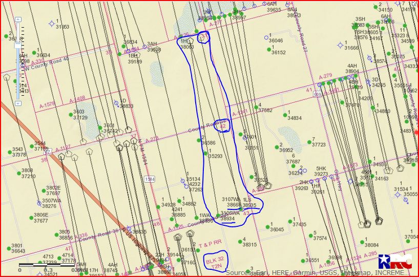
Diane, these 2 horizontal wells are not slant hole wells. They are located just to the north of Big Springs and into the northern city limits of Big Springs. They are drilled and producing from the Spraberry (trend area) formation. Well 227-38845 2AH is very similar to 1AH.
This link is to the approved drilling permit for well 227-38840 1AH:
Link to Completion Report on well 227-38840: 1,361 barrel oil per day/656,000 cubic feet gas per day
Clint, this month I received my 3rd check. Last month we received almost $5,000 and this month our check was just above $500. The production report included with our check showed only 2 days of production. Can you explain what would cause this change?
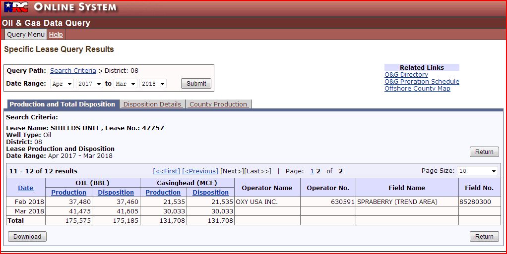
Hello Diane, I checked further and found the complete description of your minerals. Howard County Section 31 and Section 42 /Block 32 T2N (always include the T2N) (Township 2 North). Two of the permitted wells are producing (38668 & 38934). Both of these wells are commingled into Lease # 47757. As far as I can tell well 38935 was never drilled as I see no spud notification on the approved permit even though the permit was approved Dec. 2016.
My opinion is that some nearby well(s) are being fracked and your wells have been shut-in. That’s a good thing because sometimes if a well is producing and fracking is going on nearby it could possibly ruin or drastically cut back on production on your wells. Wait a couple of months and I figure normal production will resume and your checks will return to normal.
On Tuesday, June 5, 2018, 11:04 PM, Clint Liles <admin@http://www.mineralrightsforum.com> so much for the information. Is there a chance that our wells have been shut down? Only 2 days of production scares me. I can’t unlock the lingo on the production report.