I have seen the discussions about undivided interest in mineral right and have some questions.
My parents deeded me mineral rights in Grady County Oklahoma. The deed states “all our undivided” interest in Section 10, 5N 5W, etc… I have 10-1/2 acres. The deed also states, “containing 140 acres, more or less”. The spacing is now 160 acres. The lease, which I signed in 1991, has no reference to “undivided interest”. Two wells have been drilled in 10 5N 5W, mine has my last name, and is still producing as is the other well.
Does the 160 acre spacing do away with the undivided interest? Or should I be getting some payment for part of the other well that was drilled? When I get payment from Sheridan the detailed statement only shows my well. It shows the gas on one column and the oil in another.
There are so many things to consider that things keep coming up that I don’t understand.
Gracie, the 140 acres more or less is the gross acres that your 10-1/2 acres are diluted into. Like a cup of coffee with creamer, your acres are the creamer and someone else owns the coffee, the other 129-1/2 acres. It’s possible that you have acres that are not in the well spacing depending on how things are situated, the actual shape of the 140 acres that your minerals were under may not have been a square and the well spacing may not overlap the 140 gross acres perfectly. I hope this explanation is adequate and didn’t confuse you more.
My wife and I have an oil & gas lease in Payne County, Oklahoma. For 16 undivided acres of 160 acres more or less for
Section 18, Township 20 North, Range 04 East. I can find Township 20 North & Range 4 East but I have no information on Section 18 on the maps I have as to size and location on any Payne County in my files. Can anyone set me straight?
Thanks much for your info on our lease. Today I dug into our files and found a copy of the Deed for the property mineral lease. The deed reads "North East Quarter (NE/4) of Section 18, Township 20N, Range 4, East of the I. M.
containing 160.0000 acres more or less.
Is the highlighted area you sent the whole section?
Yes. That is Section 18, 640 acres. Your lease covers the NE 1/4 of the section. Although the lease says 160 acres, in most instances you have an undivided portion of the rights. Like that in 10-5N-5W at the first post on the page.
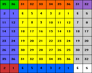
Here is a section map showing the way they are numbered. If you look at the map in the previous post you will see the number 6 two sections above and 31 three sections below. This map should help make a bit of sense of the numbering.
The Corporation Commission only shows 1 well on your lands being the Troini A located in the SE/4 NW/4. If the spacing is 160 acres and you own 10.5 acres then your net acres in the well is .065625. Multiply that times the decimal amount of the royalty (i.e. .125 or .1875) to get the amount of interest you will be paid. Hope this helps.
Has anyone else had trouble trying to type or edit from their phone on this site? The cursor seems to go wherever it wants and not where you try to place it. Very difficult to use on phone.