Camino Natural Resources obtained permits to drill 2 horizontal wells in Section 4. As I understand the documentation, one well, Black Mesa - API 051 24655, will draw from Sections 3 and 10. The other well, Great Plains - API 051 24709, will draw from Sections 4 and 9. Additionally, the well locations are identical. Forms 1001A’s - NOTIFICATION OF WELL SPUD were filed for both wells on September 5th and 9th.
I own mineral rights in Section 4, live out of state, and am amazed by the technology involved in horizontal drilling. Which leads me to a couple of questions which I’m sure y’all can help me with.
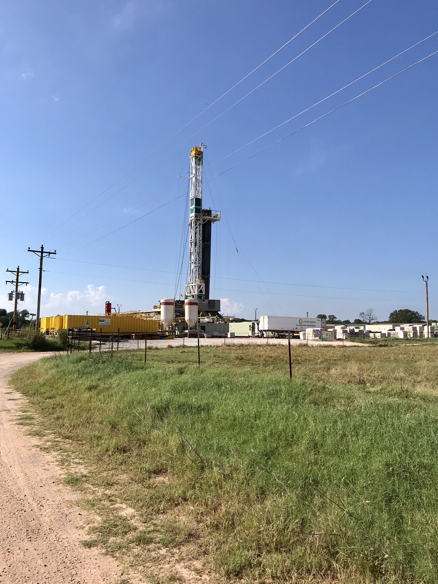
First, are there one or two holes in the surface?
Second, since the wells have been spudded is/was there an oil drilling rig on site?
Third, due to the proximity of the wells, will they likely draw from the same area and perhaps be zipper fracked?
Fourth, if there is in fact a single hole in the surface, how in the heck will they sort out proceeds to the owners? (Linear measure per section?)
There probably will be two different holes at the surface, just a few feet apart. The technology exists to do a single hole, but it is not used very often. The rig can skid over.
Yes, there was a drilling rig on site. They may have used a spudder rig or they may have used a big rig. Didn’t research that far.
Black Mesa is a planned Woodford reservoir well. It is in the name 1WH (also listed in the permit)
Great Plains is a planned Mississippi well. It is also in the name -1MH. The Miss reservoir is shallower than the Woodford which is Devonian in age.
When the wells are finished, they will run a borehole survey which will determine exactly where the boreholes went in x,y,z space. They will also spot the top of the perforations and the bottom of perforations in each borehole.
The royalties are calculated on the following formula:
net acres/spacing acres (actual) x royalty x % perforations in your section. (the spacing is 640, but sections on the northern tier of a township are not always an exact 640 acres.)
Ms. Barnes, this neophyte appreciates your replies.
Thank you.
Martha, do you know if the rig on 4-5 North-5 West is gone? I saw the date the well was spud on OCC. Is there other info I can find on OCC about the well at this time?
Thanks.
I am wondering why Camino did not add Sections 4 and 9 to Sections 3 and 10? Doesn’t Continental drill horizontals that can combine half a dozen sections? And especially since the well locations are being drilled on Section 4 and are right next to each other. Why drill on Section 4 and go across to 3 and down to 10?
Given that the Great Plains 0505 4-9 was spud on September 9 and Black Mesa 0505 3-10 was Spud on Aug 5, the rig that is capable of drilling to the complete TD on both wells is probably still there as they have months left to go. Maybe someone on the forum lives nearby and can see. Nothing will be posted on the OCC until the survey and completion reports which will be months from now.
It typically takes about four-five months to drill and complete a two section well. Times are getting shorter, but that is a ballpark. Two wells are being drilled here. One into 4& 9 and one into 3 & 10.
It is cheaper to have one drill site than to have two. They choose a nice flat spot. If you look on the OCC wellrecords website, you can see the paths of the wells.
Mineral owners are glad they did not have more than two sections at this point for each set of wells. I would rather have them prove up each 1280 than hold my acreage by four sections or more and diminish my decimal interest. Possible to hold my acreage without ever drilling it. They can unitize after they have proved both areas up and then infill drill. I can explain further if necessary.
A spudder rig was more than likely used to spud the wells. The big rig moved in on September 16th (Monday)… (Per the landowners where the SHL for the wells will be via the guy who trims our horses’ feet  )
)
Thank you very much Mr. Bray.
Thanks for that information Don!
Again, thank you Mr. Bray. That’s a pretty picture for a rookie to see!
Looks good! Thanks so much Don.
I own 25 NMA in Section 4, Township 5, Range 5. Camino has purchased a lease on the property from Sheridan. I receive small royalties, 3/16, on two vertical wells in the Section. Camino is currently drilling the Great Plains horizontal through the Section.
My question: What will be my individual involvement in any pooling?
Lee, your interest is more than likely HBP unless you have specific clauses in your lease. Your interest will probably not be pooled.
Mr. Baker - I’m new to this. Thank you for taking the time to confirm what I had expected would be the situation. However, there’s no way I’m not thankful with what’s happening with the drilling!
Go back to your original lease or pooling. If your lease had a depth clause (not very common until recently) then you have to read those terms and see if you are open to lease or pooling at the new depth. If no depth clause, then you are probably held by production (HBP). If you were force pooled for the shallow zone, then you may be open at deeper zones. It depends upon the wording of the original pooling. You are most likely held by the terms of the original lease. If you are open, you will get a notice of the pooling from the OCC.
M_Barnes,
Can you clarify what you mean when you say “you may be open at deeper zones”? That seems to suggest that you also “may not” be open. HBP is a confusing term for me as it seems to imply that if our minerals in a given area are indefinitely held by virtue of an existing lease with a well producing from a particular zone, that another operator can come along and drill to an entirely different zone of which we own minerals in and we wouldn’t get benefit from that production, which is of course theft. I’m fairly certain that’s not what HBP actually means, but can you see how it seems confusing for us mere mortals?
Thanks as always.
This is a bit off topic, but I’m reminded again of the many posts from Ms. Barnes cautioning to have all the right/protective provisions in a lease. A little while back I posted a question asking if there was a lease template or example available which included all the best provisions for a lessor. If there was a response, I did not see it. Maybe I didn’t know where to look for a response. Anyway, I hope to see one. Maybe others would too.
Ms. Barnes, the original lease was signed with Anadarko in 1994. Very short and not too sweet!
An old gross lease at 1/8th can sometimes be better than a new onerous net lease at 3/16ths. If you don’t have a depth clause, then you will just sit back and see what happens with the new deeper drilling.
Richard, may of us that have our own custom leases are a bit hesitant to share as we do not want to be construed as giving legal advice when not authorized to do so. There is really no “one size fits all” lease. Each one has to address the issues at hand. Some companies won’t deal at all, some are adaptable to certain terms, but not others.
In my opinion, the “NO POST PRODUCTION DEDUCTIONS” is the most important clause of the newer leases. They must be worded exactly right (and it is a slippery world out there that keeps changing. Many of the operating companies are trying to put post production charges in their leases when Oklahoma is an “implied covenant to market state.”
Some of the clauses that I care about are the depth clause, the time limits and wording on the shut in clause, a commencement of drilling clause, no warranty clause, no using oil, gas and water without getting paid, etc.