Both of my parents passed away last year and I need help sorting everything out. Chevron was paying on several royalties and then stopped paying everything and said that one was a mistake. Now EQT has taken over and I’m getting a different story from them. I don’t know who or what to believe and I am needing someone to look through maps and tell me what is and isn’t ours. - Thank you Amy Hill
Amy sorry for your loss and welcome to the forum. Your best bet would be using an attorney in the area to clear this up. That said if you want to share your land parcel numbers I would be happy to look them up and see if we can determine any existing wells and if they are pooled which would show the acreage in the unit. That would give you better information to deal with EQT who has probably acquired the original Chevron lease holdings. My wife and I hold producing mineral leases in Marshall Co and have learned quite a bit through the process. You should certainly contact EQT owner relations and see what they say and what they need to get you established as the owner. They will need an affidavit of heirship and probably death certificates at a minimum. A mineral rights attorney can really assist here. Good luck. Here to help in a confusing business.
I can look more, but this is the information I’m seeing on some of the paperwork. 55.83 acres tax parcel 15-0016-0007-0000-0000. Aaron & Jana Parry. Would you be able to see anything with this information?
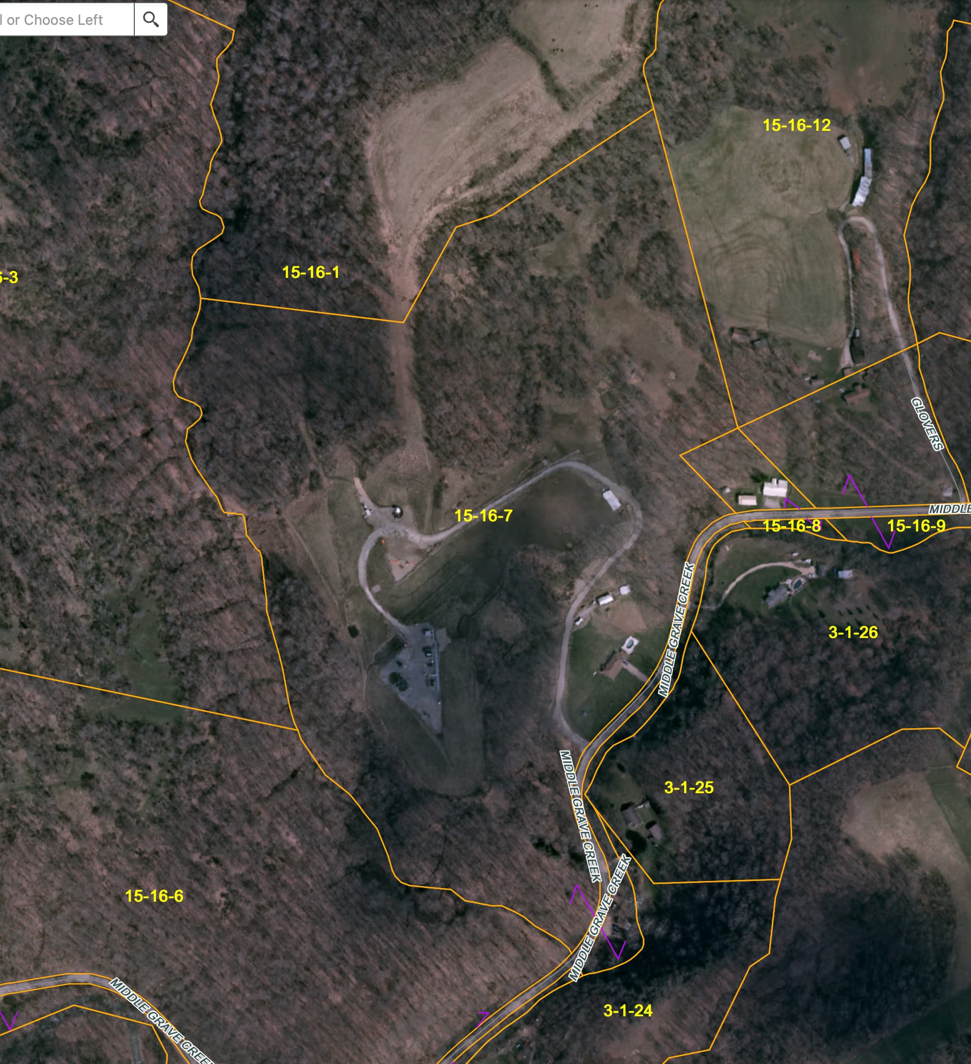
Amy, I believe I found your parcel 15-16-07 SE of Moundsville and I will try to send a screen shot of the GIS map in the morning. There appears to be a producing gas pad right in the middle of your acreage. Let me do some more research and I will get back as soon as I have more. Definitely something operating there.
Thank you so much for checking on this for me. I can’t tell you how much it’s appreciated.
Amy, Initial research on the 15-16-07 tax parcel shows it located in the Webster District of Marshall Co.There is a well named Crow 1 with an API # of 4705101395 on the property. I checked the production numbers for last year 2020 and it does not show any production. I believe it was permitted back in 2013-14 timeframe with Chevron. I attached a screen shot of the tax parcel and you can see a well pad on site. Not sure what the status currently is. Will continue to search and if I find more regarding this parcel I will forward. I suggest you go to this address Marshallcountywv.org and select County Clerk and then click on the Click Here button on the right which will bring up a page where you can enter your father’s name. There are numerous entries regarding various leases etc. See if that helps clear anything up.
Thank you so much. The Crow matches up to what I am seeing in the paperwork that I found, and It also makes mention in a separate division order that 13.48 acres is on a Curry West pad? But, it is showing Curry West, Curry 8H and Curry 9H. How can you tell these things apart from others, and would I find it on the website that you suggested above?
Amy, I found the Curry West pad in parcel 14-10-15 in the Washington District. Your father’s relationship with that is thru the Curry West Unit (pooled) which is located in Book 1052, Page 290 on the Marshallcountywv.org website. Take a look there. He had 13.41 acres in the unit from his 15-16-7 parcel in Webster District. Some of the wells in that unit are producing with EQT. It appears that the 1781 & 1790 wells you asked about are capped currently and not producing. I found a letter from WVDEP that stated that EQT has until the end of 2022 to put them into production or there will be enforcement action. Best contact EQT Owner Relations and see if they can sort this out. Will pass along anything else that pops up.
Also regarding the Curry West Unit the well API 47051017790000 definitely crosses the 15-16-7 parcel and your father was listed in the permit as both a surface and royalty member. There should be royalties from that producing well to request from EQT.
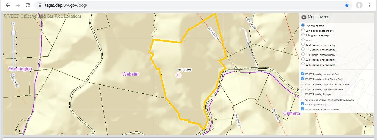
Here is the screen shot from the WV oil & gas map.
The parcel outline is shown with the Crow Well( API 47-051-01395)
and the lateral for the Curry 2H (API 47-051-01779) shown on
the parcel.
Thank you so much for giving me some understanding to all of this. Your help was greatly appreciated!
This topic was automatically closed after 90 days. New replies are no longer allowed.