I’m trying to figure out the RRC GIS. For example - in Reeves County, Texas, Block 56, Section 36, Township 3 there are 14 horizontal well symbols with a line that leads to a blue circle. I assume these are permits? Also, there are 2 blue circles with no lines and no horizontal drilling symbols. What’s the difference? I am being told that there are also producing wells in this section, but I don’t see any producing well symbols. How often does RRC update this page?
The map legend is on the left. Permits are in fact the blue circles. The ones without lines are vertical well permits, the ones with lines are horizontal well permits.

I’m pretty sure the RRC is about as up to date as the data that comes in. However, production data can lag up to 3 months.
The blue circles with lines indicate horizontal wells… the blue circles indicate vertical wells.
http://wwwgisp.rrc.texas.gov/GISViewer2/GISViewer/docs/Public_GIS_Viewer_Legend.pdf
On the legend it says the blue circles are permitted wells. Does this mean that they have not been drilled yet and are only permitted? It is my understanding that there are producing wells in that section. If that’s the case wouldn’t there be a solid green “oil” circle on the producing wells? In other words is the blue circle a permit to drill or is it a drilled producing well, or could it be either/or? Sorry to be so ignorant. ![]()
This thread has been moved to the Reeves County, TX area as it will be more helpful there.
These are approved locations with approved permits. Drilling could be beginning or proceeding in these areas but it will not show up as a spudded (begin drilling) well for a while. I find no production or producing wells in this Section 36.
After checking further on these wells I find that Apache shows that well 389-35991 was spud (begin drilling) on June 19, 2017:
CLICK ON DOCUMENT TO ENLARGE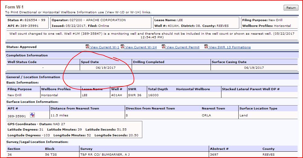
BEGIN DRILLING Apache has also spud wells 35992 on June 22, 2017; spud well 36656 on March 4, 2018; spud well 36657 on February 3, 2018; spud well 36658 on January 7, 2018; spud well 36659 on January 9, 2018; spud well 36994 on July 1, 2018; spud well 36995 on July 6, 2018; spud well 36996 on June 20, 2018; spud well 36997 on June 26, 2018.
As far as I can tell wells 37380, 37381, 37455, and 37456 drilling has not begun per the Railroad Commission website.
1 Like
Do you have holdings in this Block 56, Section 36, Township 3? I do too but have had little information from Apache since late last year. We have had inquiries from pipeline and electric. Royalties are coming monthly, but I really don’t have a clue.
Yes, I have interest in 30, 32, 36, 38. There is a title issue for about 100 people in these areas, and Carrizo says it could be months if not years before the title issues are settled. Contact Kent Gowen at Carrizo if you feel like you may be affected. kent.gowen@carrizo.com.
I have had no inquiries from pipeline or electric.