Have interest in 102 acres in S/2 Section 64 Block 1, HT&B RR Survey. Is there any drilling activity in this area? Who is leasing in this area?
Welcome to the Forum. Attached is what the Railroad Commission map currently shows happening in the area you asked about. The south half of Block 1, Section 64 is outlined in red.
If you haven’t heard about it, Peregrine Petroleum Partners, Ltd. got a permit approved last April for the horizontal well that’s shown extending across the east side of Section 64 from a drill site further south in Section 56. The drilling unit Peregrine formed for what they called the Bright Unit includes 543 acres out of Section 64 and the section joining it on the south but it looks like only the easternmost 69 acres in the south half of Section 64 is in the unit. The permit doesn’t show if the Bright well has been spudded.
A couple of sections further south Peregrine has several other wells recently completed or at the permit stage.
Thanks Dusty, your response is greatly appreciated.
Are the green dots a gas well’s bottom hole?
If it has a diagonal line through it, does that mean it’s a dry hole or a plugged gas well?
Dusty how did you highlight that half section in red? Thanks
I did a snip of that part of RRC’s map and opened it in Paint to outline the area Ouengr was asking about. May be simpler ways but that works.
Ouengr
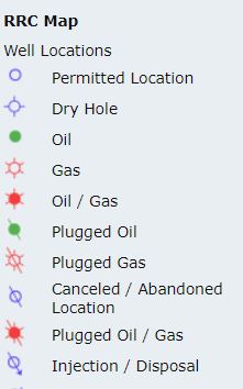
Below is the part of the legend for RRC’s interactive map identifying the most commonly shown symbols. The green dots should be the location of vertical oil wells that are still producing, or at least that haven’t yet been reported to RRC as plugged. Green dots with a slash are plugged oil wells.
A clear circle outlined in blue is a permitted location that hasn’t been drilled (or at least not reported to RRC). A permit expires if drilling hasn’t started within two years of the date RRC approved it. The clear blue circle with a slash is supposed to identify permits that were abandoned and not drilled, but in lots of instances the original permit symbol never gets changed. You need to check the date on a permit to know if it is still active.
If you are interested here is the link to RRC’s GIS map section. That page also includes videos on how to use it.
https://www.rrc.texas.gov/resource-center/research/gis-viewer/
This topic was automatically closed after 90 days. New replies are no longer allowed.