What is the current drilling environment in Nacogdoches County, specifically the JA Chireno Survey area? I received a substantial offer to purchase my mineral rights. My dad has leased these twice for 5-year terms each time and no wells were ever drilled. Wondering if it would be better to take the purchase offer instead of waiting another 5-10 years for someone to actually drill. Thoughts?
JA Chireno is a huge survey. Can you describe where in the survey your minerals are located? Aethon is doing lots of drilling in the area. Who was your lease with?
It just says Jose Antonio Chirino A-17. I don’t remember the full name but it was Petroleum something. From what I can find, it doesn’t look like they ever drilled anywhere over there.
Think that survey is spelled Chirino. Abstract 17 is very big and without knowing which part you’re in it’s hard to say. But it looks like four wells Aethon recently completed on the north side of that survey, and four more 9000’, stacked lateral permits they got approved in that same area last month, could be generating interest.
Before getting serious about selling I’d try to learn more about what’s happening in your specific part of the survey.
If you consider selling you might also keep in mind the possibility of hedging by only selling part rather than the full interest.
1 Like
How do I determine which part of the survey the mineral rights are in? I have located the deed but the description of where the land is hard to determine.
Those horizontal wells to the northeast of your property are configured that way because there is a fault at the southern end of them.
Same as the wells to the south of you. They stop there because of the same fault that runs through there.
Your property either in that fault or very close to it. If someone is willing to make a strong offer there I would consider it closely.
Wouldn’t the company that wants to buy them know about the fault? If so, why would they still be offering so much. Also, he informed me I only own the rights to 25 of the 51 acres.
No. Most mineral buyers don’t have access to geology, but some of the more sophisticated groups do. People unknowingly buy faulted minerals all of time. In fact, there’s been a couple of trades in this same fault near your property. I’ve evaluated deals in this same area that’s why I have some intel.
I’m not advising you either way. If the deal makes sense for you, I think you should consider it. That’s all I’m saying. The potential fault is just another piece to consider in your decision making process. As someone posted earlier, selling a smaller portion to hedge your bets is a popular option in this scenario.
I don’t know exactly how to respond to “offering so much” without knowing what the offer is. Maybe they are factoring in the risk with the offer. Want to share ballpark offer amount? I can add some thoughts if I know what the offer is.
That’s not a great offer for 50% mineral rights in 51 acres.
If they aren’t discounting for geologic risk, that is a pretty lowball offer. Mineral rights in that area are pretty valuable. If you decide to sell, I would ask them for $225K.
I already asked him to come up and he said he couldn’t. So maybe I will just sit on them and see what happens. Thanks for all your help!
The faults don’t go to the center of the Earth! So faults don’t always make a good or bad difference. These mineral rights are very valuable. Wells are going to be drilled in the area some more in the future.
Operators aren’t drilling to the center of the earth in this area as far as I know. The Haynesville is faulted here and it makes a “bad difference.”
1 Like
jlynn
Typically a mineral sale deed will say the grantor conveys the full interest they own, so if you think your mineral interest may be 51 acres but the offer is only based on it only being 25 that ought to be pinned down before making a decision on selling.
That could take some digging in the County deed records looking for prior mineral reservations. You could start by seeing if the group making the purchase offer will share the title information they have that determined the size of your interest.
You mentioned your father previously leasing that interest. Do you know what ownership interest those leases were based on?
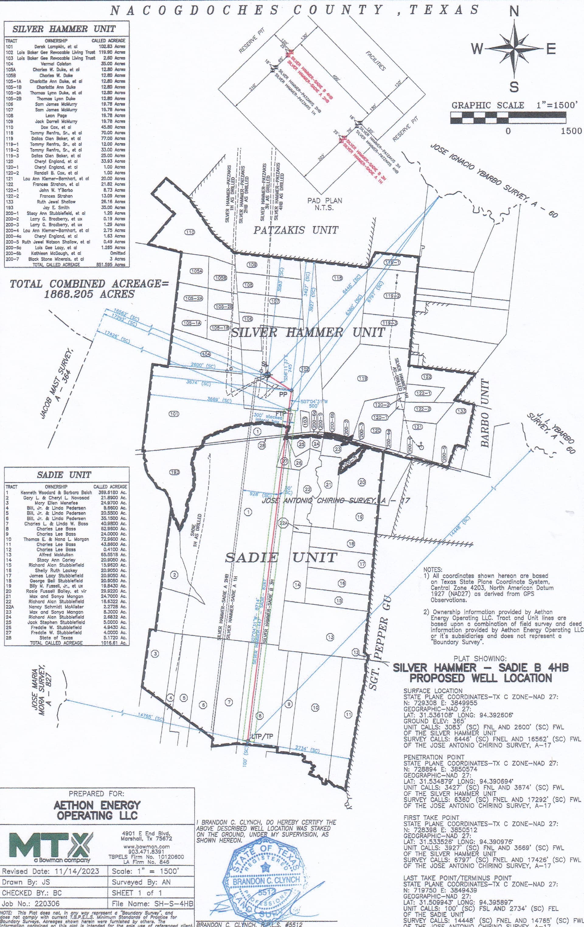
Based on the area you circled on RRC’s map it looks like you may be less than a mile from the 4 wells Aethon permitted last month. Below is the plat Aethon filed with the permit for the 4th well, called the Silver Hammer-Sadie B 4HB, which also shows the proposed horizontal legs of the other three wells (two sets of stacked laterals) and the ownership makeup of the units. You might try contacting some of the landowners that are between you and those wells to see if they are willing to share information about their lease status and whether they’ve also been contacted about selling. For the ownership of tracts outside the proposed units the Nacogdoches County Appraisal District’s website has a GIS map that will show at least the surface ownership in that area east of you.
2 Likes
Is there info in the plat that I can use to tell if my mineral rights are in this area?
From what I can tell, my mineral rights should be the next piece of property that connects to #3 plot of land on the west side. Is the red line where they are drilling?
So the owners listed on the plat may or may not have been contacted yet about leasing their mineral rights?
The four permits Aethon got approved last month were for allocation wells they plan to drill in a new unit they formed by combining existing units called the Sadie and the Silver Hammer. The dark lines on the plat I attached earlier represent the boundaries of those two units they put together to form a new, nearly 1,900-acre, allocation unit. If you aren’t familiar with allocation wells use the Looking Glass feature at the top right side of this page, putting in a key word like ‘allocation well’ to read previous posts discussing them. You’ll find lots.
With the possible exception of a few small out pieces, Aethon probably has leases on all of the mineral interests within the boundaries of those two existing units. If your property isn’t within those unit boundaries then you won’t be part of those new allocation wells. Like I mentioned earlier, if you are interested in trying to learn the status of other tracts around you, you could use the map on the appraisal district’s website to find who owns pieces in your area that appear to be outside those unit boundaries, and try contacting some of those folks to see if they are under lease or have gotten purchase offers like you did.
The red line you asked about on the plat is the route proposed for the horizontal leg of the well Aethon is calling the Silver Hammer - Sadie B 4 HB. At the right side of that red line is another line representing the proposed path of the well they designated as the B 3H. The permit says the 3H and 4 HB are stacked lateral, meaning instead of being drilled next to each other like shown on that plat, the drilling of each one will follow same general route but at different depths in the formation.
Further left (or west) on that plat are two lines representing the proposed horizontal legs of the stacked laterals Aethon called the Silver Hammer - Sadie A 1H and B 2HB.
If you aren’t familiar with allocation wells use the Looking Glass feature at the top right side of this page, putting in a key word like ‘allocation well’, to read previous posts discussing them. You’ll find a bunch.
Anyone have any thoughts about US Mineral Exchange or Texas Royalty Brokers? I have spoken to both in the last two days just to get an idea of the process and what they may think they are worth (with full understanding that they are trying to make a commission). Both have said the mineral rights are worth more than the offer I received. Just trying to weigh my options, no decisions have been made yet other than turning down the offer I had received. Y’all have been really helpful and I really do appreciate it! Thank you!
Does the fault extend to the northern end of the Moss Creek unit? It has underperformed.