Hi, I have a lease expiring 12/17/2022 and the lessee is attempting to spud prior to this date. Does anyone have real-time rig monitoring? Thanks!
Sounds like you need eyes on the ground, but it could depend on the specific wording in your lease.
Is it really spud date, potentially meaning “rig in place capable of drilling to permitted depth, with bit on the ground turning to the right,” or just say “start of operations” (that arguably might mean just starting dirt work on the pad, drilling a water well, or moving in a spudder rig)?
1 Like
Here’s the language: If oil or gas is not being produced in paying quantities from the Lands on or before the Expiration Date, but Lessee is then conducting Operations on the Lands, this Lease shall remain in force and effect as to the Lands so long, and only so long, as Lessee shall conduct Continuous Drilling Operations on the Lands. For the purposes of this Lease the term “Operations” shall mean operations for and any of the following: actual drilling, testing, completing, reworking, recompleting, deepening, plugging back or repairing of a well in search for or in an endeavor to obtain production of oil or gas, or actual production of oil or gas. For the purposes of this Lease, the term “Continuous Drilling Operations” shall mean that not more than 180 days shall expire between the date of completion of a well or the abandonment as a dry hole of a well (such date to be deemed the filing of a Well Completion Report with any agency having jurisdiction in the premises (the “Agency”) and the commencement of Actual Drilling Operations for the drilling of the next succeeding well to the development of the Lands to the density of maximum allowable production. For the purposes of this lease, the commencement of “Actual Drilling Operation” shall mean that the first operation conducted after the conductor casing has been driven, spudding operations have been completed and the kelly has been raised and the first joint of drill pipe has been secured on the drill stem. If Lessee commences Actual Drilling Operations on a well within 180 days after the date of completion or abandonment of the previous well, the difference shall NOT be credited towards the next period of time for the commencement of the next well nor carried forward or cumulated in any manner.
If Lessee fails to conduct Continuous
fwiw, Enverus has rig locations from GPS data which is, in theory, real-time. Reeves rigs according to them.
Sounds like they just need to have done something prior to 12/17. Then the Continuous Ops clause kicks in. But I hate reading lease language so shrug.
1 Like
Not an attorney but that looks like a solid clause. But that doesn’t mean it wouldn’t take a lawsuit to enforce it.
From your original post I’m assuming you’ve confirmed your lessee has a permit approved and has included your acreage in the drilling unit they platted, otherwise there wouldn’t be a question if the lease was terminating at the end of the primary term.
If they have a pad built and your objective is to document there is no rig working there on 12/17, why don’t you try posting the location and see if someone local who is on the forum would drive by and take a picture for you? If that doesn’t work, and you think it’s worth the cost, I expect there is near-real time aerial photograph you could get focused on that area.
3 Likes
Excellent response. Today is the day for expiration at midnight… and have requested the drill rig reports, which have been granted, but I have not received anything.
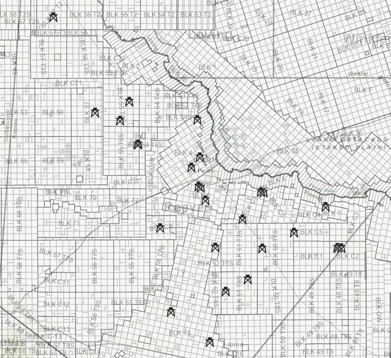
Four wells have been permitted in Section 11, Block C4, Reeves County, Texas. The first well slated to spud is the State Gypsy 16-4 A 1WA.
Is anyone local to check on this location today? The location is adjacent to the highway, so it should be an easy access. I know it’s a crazy ask.
Thank you!
1 Like
If someone on the ground in Reeves County is game to do a drive-by for you I expect they’ll need a more specific location on that drill site. It appears to be in an isolated spot a mile north of FM 1450 about 17 miles east of Pecos.
The unit plat below shows the termination point of the horizontal leg is in PSL Block C4 but the drill site is up in Section 16, Block 7 of the H&GN RR Survey (per 16-4 designation in the well name).
The blue dot on the RRC map below is the drill site. A rig might show from FM 1450 but to document that a rig wasn’t working would require driving to the pad which may not be possible. It looks like you would have to turn north off 1450 on County Road 104 and go 3+ miles to where an oil field road turns back south, then another 1/2 mile or more to the site. If someone is willing to try but can’t get by there for a few days it would still help pin down what’s been happening.
The tax records show Desert Partners in Midland owns part of the surface in Abstract 4354 where that well site is located. They might be able to tell you if it has spudded. From the name State Gypsy the State probably owns a lot of the mineral interest in that unit.
1 Like
I’d be glad they are drilling your minerals and accept that you are in partnership with them. If it’s not an egregious breach of the lease terms, I’d just be chill about it, but that’s just me.
Current rig GPS coords show no rig at the State Gypsy pad, fwiw. Not necessarily gospel…
1 Like
Absolutely, it is a partnership and we always want win-win. Thanks for your research! You are so helpful.
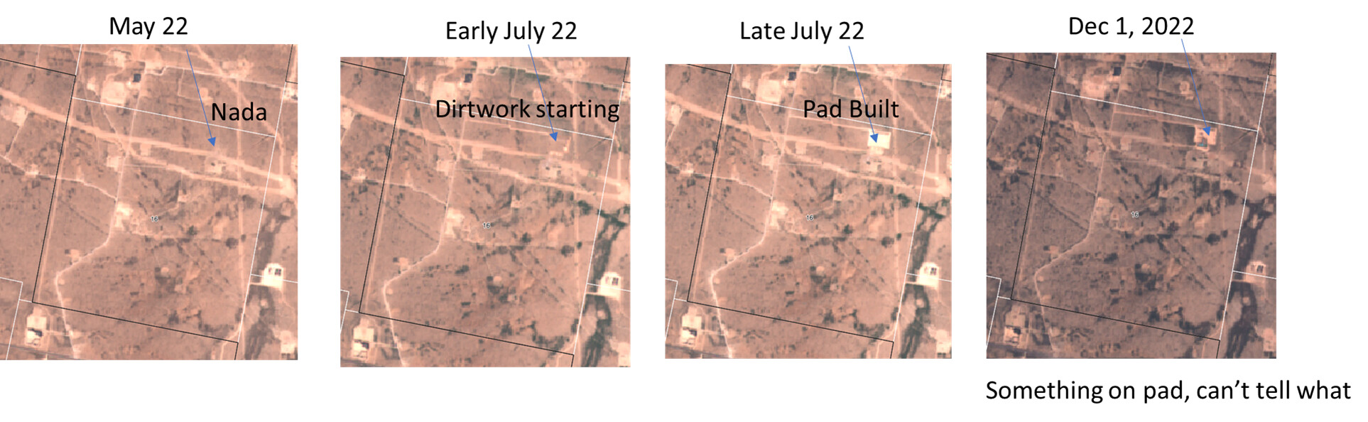
FWIW, low-res satellite time info. They built a pad mid-year. Looks like there is some equipment on the pad early December. I don’t think it’s a drilling rig, but again, low-res pics. Diamondback has two Akita rigs nearby but drilling on other units according to (not always correct) GPS.
2 Likes
Thank you. Do you have any images for 12/17/22? This is really amazing.
Curious where you found satellite imaging. I want to check on drilling on Block 50, Township 7, Section 47, 48, 38, 37 and 35, 36. About 16 miles south of Pecos on 285.
2 Likes
Have nothing for 12/17/22. I had a login for somebody’s paid satellite imaging earlier this week ![]()
I don’t see any rigs or wells spud (last 2 months) in public data for Township 50, Range 7, those sections.
Thank you for looking. Do you happen to know the company that you can buy satellite imaging from? Happy Holidays!
1 Like
NMOilBoys satellite images are probably from Enverus, but you can also get satellite from independent imaging like SentinelHub.
1 Like
This topic was automatically closed after 90 days. New replies are no longer allowed.