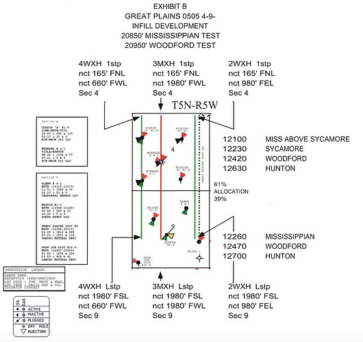
I find it helpful to put the cases in numerical order and then by date with the newest on the top.
There are quite a few cases for that section. They have a case for each required step before they can drill-Increased density, permission to drill, location of the well and allocation of the well.
2023-001982 Increased Density-sec 4-Woodford-no current Woodford well. Requests two new wells-see green wells on the map below
2023-001983 Increased Density-sec 4-Mississippian. Great Plains 0505 4-9-1MH was completed in the Miss & Sycamore, one more well requested in the Sycamore. See red well on the map below
2023-001993 Increased Density-sec 9-Woodford-no current Woodford well. Requests two new wells (other half of the same two wells in 4 from 1982-will be multi unit wells) See the map below
2023-001996 Increased Density-sec 9-Mississippian. Great Plains 0505 4-9-1MH was completed in the Miss & Sycamore, one more well requested in the Sycamore (other half of the same one well in 4 from 1983-will be multi unit well)
2023-001997-Multi-unit test Woodford-sec 4 & 9-they always mention the zones immediately above which in this case are the Sycamore and the Mississippian. Sometimes, they mention the zone below which in this case is the Hunton. The well bore will go through the Sycamore and the Miss before reaching the Woodford. May accidentally go into the Hunton. 980’ from the east line, so well 2WXH on the map. (W means Woodford)
2023-001998-Location Exception for the well above. Moves it to the east side of the section from the originally mandated middle of the section.
2023-001999-Allowables and exceptions for drilling close to other wells. for 2WXH
2023-002000-Multi-unit test of Miss & Sycamore, may accidentally go into the Woodford. This is well 3MXH 1980’ from the west line.
2023-002002-Location Exception for the well 3MXH above. Moves it to 1980’ from the west side of the section from the originally mandated middle of the section.
2023-002005-Location Exception for the well 4WXH. Moves it to 660’ from the west side of the section from the originally mandated middle of the section.
2023-002006-Multi-unit test Woodford-sec 4 & 9-they always mention the zones immediately above which in this case are the Sycamore and the Mississippian. Sometimes, they mention the zone below which in this case is the Hunton. The well bore will go through the Sycamore and the Miss before reaching the Woodford. May accidentally go into the Hunton. 660’ from the west line, so well 4WXH on the map.
2023-002007-Exceptions for drilling close to other wells for 4WXH
2023-002008-Allowables and exceptions for drilling close to other wells for 4WXH
I may have missed the allowables case for 3MXH
Long winded answer, but you have two wells testing the Woodford and one well testing the Mississippian and Sycamore which are above the Woodford. You already have one Miss well in the original Great Plains 1MXH well. Think of the two sections as a two layer cake with four bendy straws going into it-two into each layer. They will use the same surface pad in 4 even though the map makes it look like different locations. The will each drill down and then splay out into their assigned path. They will probably drill all three first and then frac them later. Don’t expect revenues for about a year. Four-five months to drill/complete and then about five months to get the Division Orders out.
