Hello to All! I am a new land owner for Block 45, Section 37, Lot 24. I am new to the forum for Reeves County and would like to know if anyone has heard anything of potential activity in or around my area?
Keith, I see where Carrizo (Permian) LLC has some very good gas wells (with condensate) in this area of Reeves County.
GIS Map of Reeves County Section 37/Block 45/A-3498

DOUBLE LEFT CLICK ON MAP TO ENLARGE
1 Like
Thanks Clint! I am a surface owner of 5 acres. I see now that there are definitely advantages to being that if in the right areas.
Hi I haven’t checked in to the site for a while. Clint, you post such great maps, I was wondering if you could tell if anything, that is oil production related, is happening on my little corner of Reeves County. That is Block 13, Section 39. State 10 and Business 10 area. Thanks for any help!
Hello Melissa.. Your acreage is in the area of the Alpine High that Apache Corp. is developing…some good gas wells in this area with condensate. Apache is still developing this area as I see a permit here approved in September and drilling has begun for a well about 2 miles to the North of your acreage.
GIS Map of Reeves County Section 39/Block 13/A-464
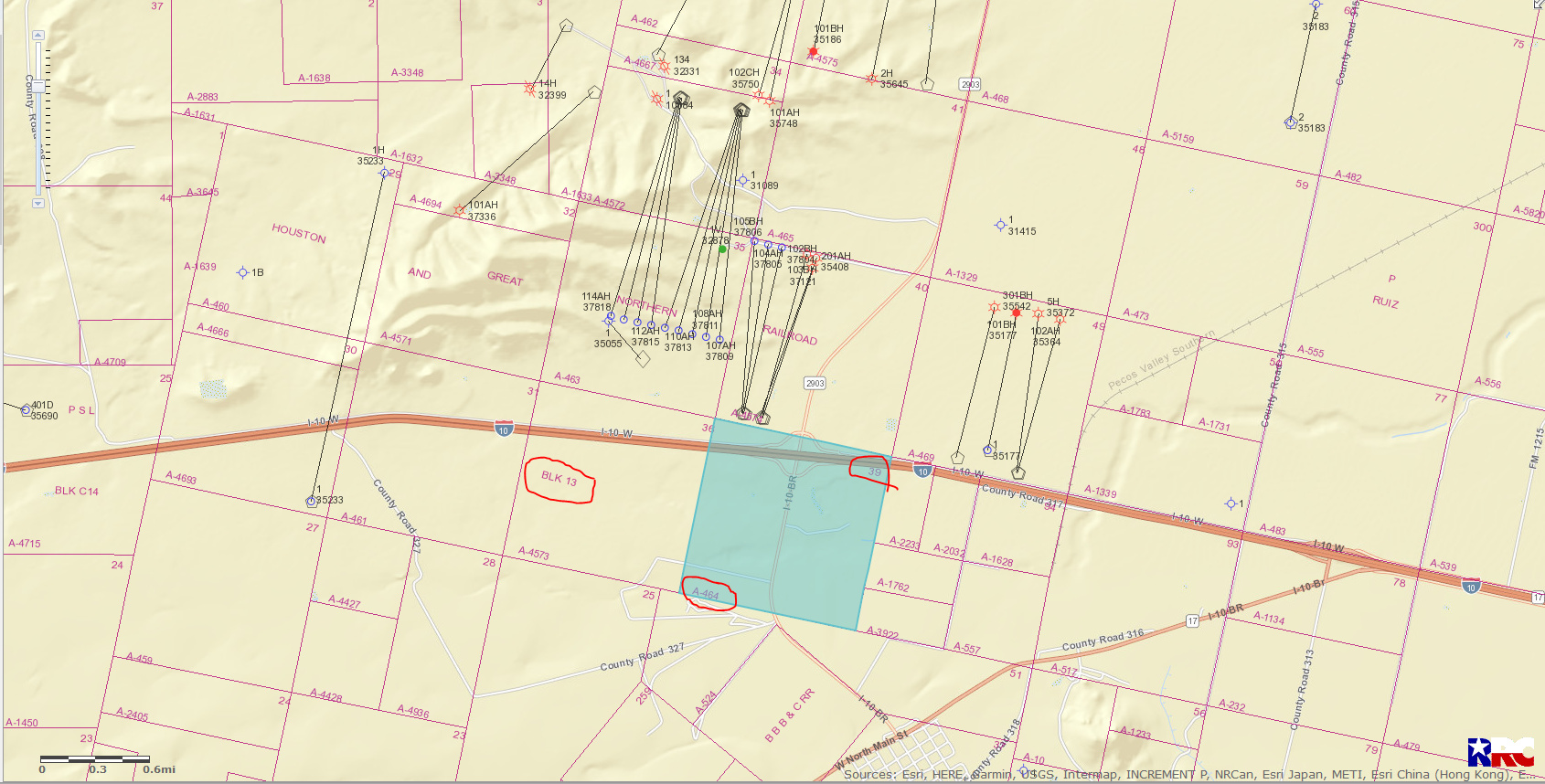
DOUBLE LEFT CLICK ON MAP TO ENLARGE
1 Like
Thanks for the map. Does it look like Apache will resume with new drilling sites in the spring?
I would assume that their drilling program will resume after the new year.
Good luck with your acreage…and glad to see you back on the Forum.
Thanks Clint. Excited to be back!
Hi Clint! I am new to this forum. I own rights in the following:
BLK 57T1, Tract 41 and Tract 32
I am new to all of this and just now beginning my research. Would you mind sending me a map of that area like the ones above with any details you can provide? I know nothing about any of this and would appreciate any info you can give.
I appreciate your time.
Hello Valarie, sorry I’m so late getting back to you but I’m out of town and just noticed your request. After checking your area (I am assuming you meant Block 57, Township 1, Section 32 and Section 41), I find 2 operators doing most of the drilling in this area: Anadarko E & P (Exploration and Production) and BPX Operating Co. There are numerous vertical wells in this area and some horizontal wells. Some of these wells produce oil/gas and others produce gas with condensate. There are some very good wells in this area.
GIS map of Reeves County, Section 32 and Section 41, Block 57, Township 1
DOUBLE LEFT CLICK ON MAP TO ENLARGE
Happy New Year
1 Like
Thank you so much. Is there a way to private message you? If not, no worries. I am entertaining the idea of selling them because the production has declined over the year however I don’t want to regret it later on. Is there a legend I could look at so I can better understand how to read the map? I assume the green dots are producing wells?
Valarie, this is the link to the legend you were speaking of.
https://gis.rrc.texas.gov/GISViewer/GISViewer/docs/Public_GIS_Viewer_Legend.pdf
Just wanting to let you know that there is the possibility one day that some of the other productive formations in this area other than the one that is now producing could be drilled into like the Bell Canyon, Cherry Canyon, Brushy Canyon, Bone Springs, Upper Wolfcamp and the Delaware.
1 Like
This topic was automatically closed after 60 days. New replies are no longer allowed.