We have a small interest in Section 17-10N-9W, Caddo County. We received a notice that Thunderbird has petitioned the court to combine two 640-acre units to form one 1280-acre unit for the purpose of drilling a horizontal well.
It would seem that this would effectively cut returns in half if a well did go into production. But then, I am totally a newbie!
What is the end result of this and does the court usually grant this kind of request?
Hi Susan: Here is my take on this, but others will be more expert. First, Thunderbird is a front for the actual production company. To answer your question, drillers in the past ten years are doing amazing things unheard of just years ago. They drill down (vertical) two (2) miles, turn the corner and can then drill several miles across several sections (or on one of our wells, almost three miles horizontal).
So, the petition states that drillers will now cross two miles (2) sections to double the gas collected. Double the gas, divided by double the owners (of the mineral acres) so (in effect) you will be paid for the gas that comes out of “your” section. Thunderbird will have to file a map that shows the length of the laterals in each section, as well laterals don’t cover exactly the border to border of each section. Actually, the perforations (holes) blasted in the horizontal casing are counted, and the gas is paid by the amount of perforations (holes) in each section, not by length.
As a northern person I have been doing this for 40 years, and still learn every day. My suggestion to you is to spend some quality time on the Oklahoma Corporation Commission (OCC) website and learn as much as you can about your mineral holdings, the wells in the area (some may be old vertical wells). The OCC has a “Mineral Owners Vocabulary” sheet that I use with my cousins that are trying to learn. If there is an older vertical well on that section (Thunderbird would have to lease you mineral acres if there was not an old well holding a lease), look up that well, see the production, and see if you or your relatives are being paid. You can learn, it takes hours to do so, but the rewards of understanding this ownership is considerable. It can take up to a year for payment to start on some of these horizontal wells, but the checks can be considerable, depending on how many mineral acres you own. Welcome to the club of mineral owners.
The two-three section drilling units are quite common in Caddo. The OCC frequently grants this type of spacing.
Since the well that will be drilled will be a two section horizontal well, you will have the same royalties as if you had a one section 640 acre well or one half of a longer two section well. It is cheaper for the operator to drill one longer multisection well than to drill multiple single section wells. Plus they can get more perforations out of the multisection well.
The equation for your royalties in OK is: net mineral acres/actual spacing acres x royalty x percentage of perforations in your section.
An example would be:
10 net mineral acres at 1/5th royalty and a two section well at 640 acre spacing so 50% perforations. 10/640 x .20 x .50=0.0015625 Division Order decimal.
In this case, the spacing unit will be 1280, but you will have 100% of the perforations in the spacing unit. 10/1280 x .20 x 1.0=0.0015625 Division Order decimal. Exactly the same.
Thunderbird has filed for several OCC cases in that township. The other usual operators are Duncan and BCE-MACH, so remains to be seen if Thunderbird will actually drill or cut a deal with another operator.
The pending well is in sections 17/20. The location exception case is 2026-000128. They are lining the well up 660’ from the west line, so are leaving room for additional horizontal wells in the future.
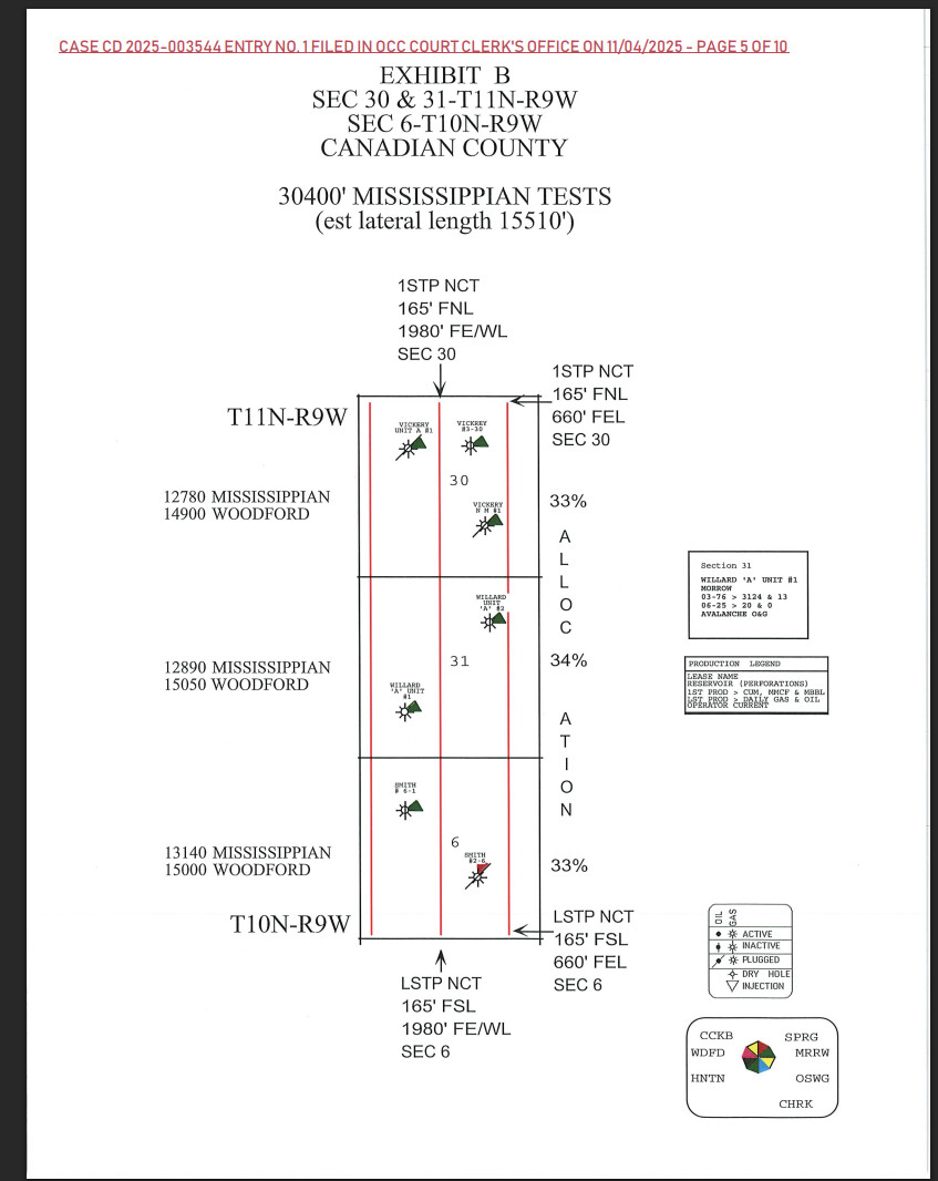
When the Multiunit Horizontal case is filed, there will be a similar map to the following exhibit. This is case 2025-003544 which is by BCE-MACH to the north for a three section well, but part of a three well program.